California hiking trails - Green Valley Trail, Northern Sierra Nevada, Placer County

   
  There are so many delightful hiking trails for trekking in California, and one of these is Green Valley Trail in Placer County. Backcountry hiking here in California is so much fun. A visit to California is not complete without some backpacking. This area does get very dry sometimes, so don’t forget to check for any current fire restrictions before you go. The lovely backpacking and hiking trails of the Northern Sierra Nevada are a very splendid way to see these mountains. Green Valley Trail is a normal length backpacking and hiking trail with very little uphill
    walking involved a perfect backcountry hiking trail for an easy stroll for the whole family. Being 5.6 miles long it's an average length backpacking trail. Even though this is not a very long wilderness trail you should still bring some emergency supplies just in case something
happens. Hitting the great outdoors trails is always an exciting thing to do, and Green Valley Trail in Placer County, California is just what you need. There are two trailheads to chose from, one in each end, so if you can get a ride from someone, you can walk it just one way. Don’t forget to check for any current restrictions or closures before you go. Every California hiking trail is worth trekking. You'll have got to go far from Truckee-Grass Valley to get to Green Valley Trail, but when you spend some time trekking here you will feel like a whole  
new person. The time needed for this backcountry trek is roughly 4.5 hours, but you never know stuff could go wrong and you could get stuck so be prepared for that. There are so many backcountry hiking trails in this neighborhood. This wilderness trail has a total elevation difference of 2,371 feet which is about average. High temperatures at Green Valley Trail during the summer months are in the 90's. Summer overnight lows fall down to the 60's. The cold days of the wintertime come with highs in the 50's while Green Valley Trail overnight low temperatures throughout the wintertime are in the 30's. This backpacking trail goes through some very different elevations which of course means you need to be prepared for different conditions on different parts of the backpacking trail. Green Valley Trail sees pretty high levels of precipitation; most of the rain falls during January, and July is the month with the least moisture.

Briefly about the general area:
Not sufficient hours in a day to enjoy this site. A good location for whitewater paddling right next door to Green Valley Trail is American River - North Fork, and needless to say Forbes Creek is a wonderful stream that is worth taking a look at. A visit to Iron Point close to Green Valley Trail is always a fine idea; Green Valley Trail is a wonderful site to visit for more than one day, Monzarita Day Use Campground is a wonderful site to camp nearby.
If you want a pleasant time in the great outdoors just come on up to the Northern Sierra Nevada. In the event that you don't mind getting dripping wet, you can always go whitewater paddling on American River - Middle Fork, and don't forget to take a great little journey to Pagge Creek. Yep, outdoors cool stuff truly is plentiful here in the Northern Sierra Nevada. You'll need more than a day to explore everything Green Valley Trail has to offer, you can camp at Forbes Campground; if you desire a little side tour, try McIntyre Gulch.
You must certainly dedicate some time to Succor Flat while you're here at Green Valley Trail; you're sure to encounter some fine folks from Truckee-Grass Valley here.

Location of Trailhead 1: Latitude 39.1548, Longitude -120.7856
- - Directions and Road Map

Location of Trailhead 2: Latitude 39.1813, Longitude -120.7786
- - Directions and Road Map


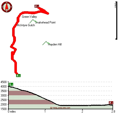
Trailhead 1 to Trailhead 2:
Total hiking length = 2.8 miles
Total climbing distance = .2 miles
Difficulty : Easy
Casual Hiking Pace: 2 hours
Fast Hiking Pace: 1 hours

Trailhead 2 to Trailhead 1:
Total hiking length = 2.8 miles
Total climbing distance = 1.5 miles
Difficulty : Medium
Casual Hiking Pace: 2.5 hours
Fast Hiking Pace: 1.5 hours
    Trailhead 1 back to Trailhead 1:
Total hiking length = 5.6 miles
Total climbing distance = 1.7 miles
Difficulty : Easy
Casual Hiking Pace: 4.5 hours
Fast Hiking Pace: 3 hours

Trailhead 2 back to Trailhead 2:
Total hiking length = 5.6 miles
Total climbing distance = 1.7 miles
Difficulty : Easy
Casual Hiking Pace: 4.5 hours
Fast Hiking Pace: 3 hours

Total elevation difference: 2371 feet


Deer Creek Inn, Nevada City
11 miles away
Deer Creek Inn is a 150 year old restored Queen Anne Victorian located in the historic Gold Rush town of Nevada City, California. The historic shopping and dining district on Broad Street is only foot...
  
Nevada City Inn, Nevada City
17 miles away
A home away from home! Comfortable, park-like setting, 2/3 of a mile to downtown Nevada City, 27 guest rooms inluding 7 cottages. We are now an all non smoking room hotel. We are a pet friendly hotel...
User input for Green Valley Trail, Northern Sierra Nevada, Placer County, California:

Submit Input:
Your Name:
Write or Paste Input here:

Upload picture:      Review Guidelines


Outdoors Recreation Near Truckee-Grass Valley, California
Very comprehensive list of a variety of outdoors recreation in the vicinity of Truckee-Grass Valley, California, the metro area neareast to Green Valley Trail. Find info on campgrounds, hiking trails, ski resorts, lakes, beaches, parks, whitewater and more.

Current weather conditions at Green Valley Trail, Northern Sierra Nevada, Placer County, California
WXPort

Local climate location: COLFAX 15 miles away

Piety Hill Cottages, Nevada City
17 miles away
9 Tastefully appointed BnB cottages in this parklike setting 1 acre with tree-shaded grassy courtyard...

Best Western Gold Country Inn, Grass Valley
18 miles away
**Hot tub closed until further notice.** Discover this pet friendly Grass Valley, California hotel offering convenient access to Empire Mine State Park, Historic Nevada City and the Tahoe National Fo...

More Hotels and Campgrounds Near Green Valley Trail, Northern Sierra Nevada, Placer County, California

OTHER_INFO
  Northern Sierra Nevada Campgrounds
Complete list of all the campgrounds in the Northern Sierra Nevada.

Northern Sierra Nevada Outdoors Info
Complete outdoors info for the Northern Sierra Nevada.

California Hiking Trails
Complete list of all hiking trails in California

Books about hiking trails in California
List of books available on Amazon.com about hiking trails in California.

California Outdoors Index
This is a very comprehensive index of outdoors activities in the great state of California.


TOPO
High quality water resistant topo map of Green Valley Trail, Northern Sierra Nevada, Placer County, California.

OUTDOORS_GUIDE
These outdoors activities are available near Green Valley Trail.
 Trails Near Green Valley Trail:
Euchre Bar Trail, Placer County , 3 miles away, 3.3 hiking miles, 1947 feet elevation difference
American Eagle Trail, Placer County , 5 miles away,  1.8 hiking miles, 190 feet elevation difference
Italian Bar Trail, Placer County , 8 miles away,  4 hiking miles, 2437 feet elevation difference
Bake Oven Trail, Placer County , 9 miles away,  9 hiking miles, 2032 feet elevation difference
Burnett Canyon Trail, Placer County , 10 miles away, 1.1 hiking miles, 753 feet elevation difference
Mumford Bar Trail, Placer County , 11 miles away, 5.1 hiking miles, 3289 feet elevation difference
Eagle Bird Trail, Nevada County , 12 miles away, 1.6 hiking miles, 1371 feet elevation difference
 Camp Grounds Near Green Valley Trail:
Monzarita Day Use Campground, Placer County, 1 miles away
Forbes Campground, Placer County, 2 miles away
Baxter RV Campground, Alta, 3 miles away
Dutch Flat RV Resort, Gold Run, 4 miles away
Chicken Hawk Campground, Placer County, 5 miles away
 Whitewater Near Green Valley Trail:
American River - North Fork, Placer County County , 4 miles away, Class IV-V - 14.5 miles long (Euchre Bar to Colfax-Iowa Hill Road)
American River - Middle Fork, Placer County County , 9 miles away, Class IV-V - 2.1 miles long (Mosquito Ridge Road to confluence with Middle Fork)
American River - North Fork, Placer County County , 9 miles away, Class IV-V - 12.3 miles long (Tadpole Creek to Euchre Bar)
American River - North Fork, Placer County County , 10 miles away, Class IV-V - 4.8 miles long (Colfax-Iowa Hill Road to Colfax-Foresthill Road Bridge)
American River - North Fork, Placer County County , 12 miles away, Class II-III - 5 miles long (Colfax-Foresthill Road Bridge to Ponderosa Way Bridge)
 Hotels Near Green Valley Trail:
Deer Creek Inn, Nevada City , 11 miles away
Nevada City Inn, Nevada City , 17 miles away
Piety Hill Cottages, Nevada City , 17 miles away
Best Western Gold Country Inn, Grass Valley , 18 miles away
Holiday Lodge Grass Valley, Grass Valley , 18 miles away
 Lakes Near Green Valley Trail
Sugar Pine Reservoir, Placer County , 2 miles away
Liberty Hill Reservoir, Nevada County , 5 miles away

Outdoors related information copyright © Stratus-Pikpuk, Inc. - Detailed hotel information copyright © Interactive Hotel Solutions