California hiking trails - Grapevine Trail, Sierra Madre, Santa Barbara County

   
  Backcountry hiking in California is such a perfect thing to do. Each one of the many hiking trails of California has something unique to offer. Grapevine Trail is a long tour away from Santa Barbara-Santa Maria-Goleta, but when you spend some time hiking here you will feel like a whole new person. Please follow all local rules about fires and camping. Grapevine Trail has only one trailhead, so in and out is the way to trek it normally. The total elevation difference for Grapevine Trail is 1,501 feet which is about average. This is one of many backcountry
    hiking trails in the surrounding vicinity. For the duration of the warm months, highs frequently are in the 90's at Grapevine Trail. Once the sun is down it sinks down to the 50's. The cold days of the wintertime come with highs in the 60's, and night lows during the wintertime
for Grapevine Trail tend to be in the 30's. Of course, this is an overnight backcountry hike, 1.5 days normally, so make sure you've got all your overnight gear packed. The length of this wilderness hiking trail is on the longer side having an average number of uphill miles which makes this backcountry hiking trail great for hard core backpackers looking for adventure. This is a long wilderness trail, so do pack enough food to last the whole trip. Some parts of Grapevine Trail are much higher up than other parts of the great outdoors hiking trail, and that  
means that some parts of the great outdoors hiking trail could be very different from other parts of it. Being 10.4 miles long; it's considered a longer walk. Grapevine Trail is pretty dried up generally; of all the months in a year February is the one with the most rain, and the driest month of the year is July. Ok, you've been cooped up too long, time to get out in nature a bit, and if you happen to be in Santa Barbara County of California, Grapevine Trail is a tremendous local backcountry hiking trail for doing a bit of leg stretching. There are so many brilliant hiking trails for backcountry hiking in California; one of them being Grapevine Trail in Santa Barbara County. At parts of the year this area sees very little rain, so make sure you check current conditions and fire restrictions with local forest authorities before you head out. Backpacking in California is something that is always fun to do. Wilderness hiking trails like this one here in the Sierra Madre are the best way to enjoy these peaks.

Briefly about the general area:
Sisquoc Falls is an inspiring site to stop at while you're here; Big Pine Canyon is also a great location to look at. Jackrabbit Flat is a great place to check out, and hey, Grapevine Creek is a glorious local stream.
The surroundings of this river have so much to offer. Mission Pine Basin is a good place; Grapevine Trail is a great place to camp, Upper Grapevine Campground is a great place. This location, the Sierra Madre, has so much outdoors exciting things. Not far from Grapevine Trail you can enjoy the trees of Los Padres National Forest, and swing by East Fork Santa Cruz Creek it's a nice location to visit. Don't try to stop me, cause I'm havin' a glorious time here at Grapevine Trail. Don't leave Grapevine Trail without first paying a visit to Chokecherry Spring, and camping at Grapevine Trail is perfect fun, Bluff Campground is a perfect local campground.
So many fun things to do in the Sierra Madre, not enough time. At Grapevine Trail you always meet someone from Santa Barbara-Santa Maria-Goleta.

Location of Trailhead: Latitude 34.6745, Longitude -119.668
- - Directions and Road Map

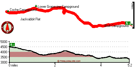
Total in and out hiking length = 10.4 miles

Total climbing distance = 4.6 miles

Difficulty : Difficult

Casual Hiking Pace: 1.5 days

Fast Hiking Pace: 6 hours

Total elevation difference: 1501 feet


El Encanto Hotel & Villas, Santa Barbara
13 miles away
  
Lemon Tree Inn, Santa Barbara
14 miles away
This full service Santa Barbara hotel features 96 modern guest suites most facing a one acre tropical courtyard with oversized heated swimming pool,sundeck and hydrospa. The Lemon Tree Inn has The Cro...
User input for Grapevine Trail, Sierra Madre, Santa Barbara County, California:

Submit Input:
Your Name:
Write or Paste Input here:

Upload picture:      Review Guidelines


Outdoors Recreation Near Santa Barbara-Santa Maria-Goleta, California
Very comprehensive list of a variety of outdoors recreation in the vicinity of Santa Barbara-Santa Maria-Goleta, California, the metro area neareast to Grapevine Trail. Find info on campgrounds, hiking trails, ski resorts, lakes, beaches, parks, whitewater and more.

Current weather conditions at Grapevine Trail, Sierra Madre, Santa Barbara County, California
WXPort

Local climate location: CACHUMA LAKE 19 miles away

Quality Inn Santa Barbara, Santa Barbara
14 miles away
Beautiful cozy rooms just two miles off historic downtown State Street. Close to Mission Santa Barbara. Walking distance to parks, shops and restaurants. Some rooms have a mountain view....

Guesthouse Inn and Suites, Santa Barbara
14 miles away
For August 1-3, 2008 and June 13-15, 2008 there will be a 30 day cancellation policy and credit card will be charged 30 days prior to arrival and is nonrefundable. GuestHouse Inn and Suites offers nic...

More Hotels and Campgrounds Near Grapevine Trail, Sierra Madre, Santa Barbara County, California

OTHER_INFO
  Sierra Madre Campgrounds
Complete list of all the campgrounds in the Sierra Madre.

Sierra Madre Outdoors Info
Complete outdoors info for the Sierra Madre.

California Hiking Trails
Complete list of all hiking trails in California

Books about hiking trails in California
List of books available on Amazon.com about hiking trails in California.

California Outdoors Index
This is a very comprehensive index of outdoors activities in the great state of California.


TOPO
High quality water resistant topo map of Grapevine Trail, Sierra Madre, Santa Barbara County, California.

OUTDOORS_GUIDE
These outdoors activities are available near Grapevine Trail.
 Trails Near Grapevine Trail:
Mission Pine Trail, Santa Barbara County , 2 miles away, 11.5 hiking miles, 1328 feet elevation difference
Buckhorn Trail, Santa Barbara County , 5 miles away,  7 hiking miles, 1939 feet elevation difference
Alamar Trail, Santa Barbara County , 5 miles away, 5.7 hiking miles, 3099 feet elevation difference
Alamar Hill Trail, Santa Barbara County , 6 miles away,  12.8 hiking miles, 1805 feet elevation difference
Santa Cruz Trail, Santa Barbara County , 6 miles away, 9.9 hiking miles, 2660 feet elevation difference
Pie Canyon Trail, Santa Barbara County , 7 miles away, 3.6 hiking miles, 1780 feet elevation difference
Mono Alamar Trail, Santa Barbara County , 7 miles away,  9.4 hiking miles, 1332 feet elevation difference
 Camp Grounds Near Grapevine Trail:
Bluff Campground, Santa Barbara County, 2 miles away
Upper Grapevine Campground, Santa Barbara County, 2 miles away
Lower Grapevine Campground, Santa Barbara County, 2 miles away
The Pines Campground, Santa Barbara County, 2 miles away
Coche Campground, Santa Barbara County, 3 miles away
 National Parks Near Grapevine Trail:
Channel Islands National Park, Ventura - CA , 35 miles away
Santa Monica Mountains National Recreation Area, Thousand Oaks - CA , 62 miles away
 Hotels Near Grapevine Trail:
El Encanto Hotel & Villas, Santa Barbara , 13 miles away
Lemon Tree Inn, Santa Barbara , 14 miles away
Quality Inn Santa Barbara, Santa Barbara , 14 miles away
Guesthouse Inn and Suites, Santa Barbara , 14 miles away
Hacienda Motel, Santa Barbara , 14 miles away

Outdoors related information copyright © Stratus-Pikpuk, Inc. - Detailed hotel information copyright © Interactive Hotel Solutions