California hiking trails - Girard Trail, Santa Lucia Range, Monterey County

   
  There are wilderness hiking trails all over California; among these are Girard Trail in Monterey County. California is a wonderful outdoors state. There are plenty of wilderness hiking trails in California; each one of them has its own unique loveliness. This wilderness trail has two trailheads, so hiking it one way is an option if you can arrange for a ride back. Backcountry trekking here in California never gets boring. The yearly rain here at Girard Trail is about average; the wettest month of the year is frequently January, that's the one that rains
    the most; July meanwhile is the driest month. Girard Trail is a very long backcountry hiking trail having an average number of uphill miles which makes this trail tremendous for hard core backpackers looking for adventure. You should count on this backcountry hike taking about
9 hours, but you never know stuff could go wrong and you could get stuck so be prepared for that. Some parts of Girard Trail are much higher up than other parts of the hiking trail, and that means that some parts of the hiking trail could be very different from other parts of it. This is a long hiking and backpacking trail, so make sure you bring plenty of supplies. This wilderness trail has a total elevation difference of 3,407 feet which is higher than average. Girard Trail is 10.2 miles long; it's considered a longer backcountry trek. This is one of  
many trails in the surrounding vicinity. Don’t forget to check for any current restrictions or closures before you go. Alright, enough of spending all this time inside a building, time to get out, and Girard Trail in Monterey County, California is a fine location to go. Girard Trail is located a pretty long tour from Salinas, but what a fine location for backcountry backpacking it is. The backcountry hiking trails of the Santa Lucia Range are a really great way to spend quality time in the fresh air. Through the warmest time of the year at Girard Trail temperatures are typically in the 70's. When the night sets in temperatures plunge down into the 50's. Daytime highs through the wintertime are in the 50's; night lows in the 40's for Girard Trail. This hiking and backpacking trail sometimes gets very dry, so make sure you check current conditions and fire restrictions with local forest authorities before you head out.

Briefly about the general area:
A good place to camp here at Girard Trail is Fresno Campground; hey, Kirk Creek is a glorious local stream. So many amusing things to do at Girard Trail, so little time. Looking for some flowing water? Try West Fork Limekiln Creek, and you can always enjoy a lazy day on the beach at Sand Dollar Beach.
Whohoo, so many entertaining things in one place! The Santa Lucia Range rules! Paddling on Arroyo Seco River is so much fun. A short spree to Redwood Spring is always worthwhile, and Lopez Point is not far at all. Now, you may assume that's loads but there's even more amusing things to do here in the Santa Lucia Range. A trip to Girard Trail wouldn't be complete without taking a look at Carrals Spring, and drift down the rapids of San Antonio in a kayak.
Near Girard Trail you find perfect places like Hare Canyon, and camping is available at Kirk Creek Campground.

Location of Trailhead 1: Latitude 36.0088, Longitude -121.5177
- - Directions and Road Map

Location of Trailhead 2: Latitude 36.0319, Longitude -121.4698
- - Directions and Road Map


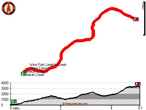
Trailhead 1 to Trailhead 2:
Total hiking length = 5.1 miles
Total climbing distance = 3.5 miles
Difficulty : Difficult
Casual Hiking Pace: 5.5 hours
Fast Hiking Pace: 3 hours

Trailhead 2 to Trailhead 1:
Total hiking length = 5.1 miles
Total climbing distance = 1.1 miles
Difficulty : Easy
Casual Hiking Pace: 4 hours
Fast Hiking Pace: 2 hours
    Trailhead 1 back to Trailhead 1:
Total hiking length = 10.2 miles
Total climbing distance = 4.6 miles
Difficulty : Difficult
Casual Hiking Pace: 9 hours
Fast Hiking Pace: 6 hours

Trailhead 2 back to Trailhead 2:
Total hiking length = 10.2 miles
Total climbing distance = 4.6 miles
Difficulty : Difficult
Casual Hiking Pace: 9 hours
Fast Hiking Pace: 6 hours

Total elevation difference: 3407 feet


Ventana Inn Big Sur, Big Sur
10 miles away
Situated on 243 acres, 1,200 feet above the Pacific Ocean. The property is known for its serene setting, rustic yet luxurious sophistication and romantic allure. Features include 26 newly remodeled su...
  
Valley Harvest Inn, Soledad
25 miles away
Welcome to the Valley Harvest Inn, located in Soledad, CA, the heart of the Salinas Valley and Monterey County wine country. Close to Pinnacles National Monument, Mission Soledad, and Monterey Bay, th...
User input for Girard Trail, Santa Lucia Range, Monterey County, California:

Submit Input:
Your Name:
Write or Paste Input here:

Upload picture:      Review Guidelines


Outdoors Recreation Near Salinas, California
Very comprehensive list of a variety of outdoors recreation in the vicinity of Salinas, California, the metro area neareast to Girard Trail. Find info on campgrounds, hiking trails, ski resorts, lakes, beaches, parks, whitewater and more.

Current weather conditions at Girard Trail, Santa Lucia Range, Monterey County, California
WXPort

Local climate location: MONTEREY 19 miles away

Quality Inn King City, King City
26 miles away
The Quality Inn features free continental breakfast, free high-speed Internet and an outdoor pool. The rooms have hair dryers, coffee makers, irons and boards and all rooms feature microwaves and refr...

King City Days Inn, King City
26 miles away
Welcome to Days Inn King City where we have 46 beautiful rooms for your convenience. We are conveniently located off Hwy 101 halfway between Los Angeles and San Francisco in the middle of wine country...

More Hotels and Campgrounds Near Girard Trail, Santa Lucia Range, Monterey County, California

OTHER_INFO
  Santa Lucia Range Campgrounds
Complete list of all the campgrounds in the Santa Lucia Range.

Santa Lucia Range Outdoors Info
Complete outdoors info for the Santa Lucia Range.

California Hiking Trails
Complete list of all hiking trails in California

Books about hiking trails in California
List of books available on Amazon.com about hiking trails in California.

California Outdoors Index
This is a very comprehensive index of outdoors activities in the great state of California.


TOPO
High quality water resistant topo map of Girard Trail, Santa Lucia Range, Monterey County, California.

OUTDOORS_GUIDE
These outdoors activities are available near Girard Trail.
 Trails Near Girard Trail:
Gamboa Trail, Monterey County , 3 miles away,  6.6 hiking miles, 1759 feet elevation difference
Arroyo Seco Trail, Monterey County , 4 miles away,  7.6 hiking miles, 2631 feet elevation difference
North Coast Ridge Trail, Monterey County , 5 miles away, 9 hiking miles, 1385 feet elevation difference
Summit Trail, Monterey County , 8 miles away, 1.8 hiking miles, 1522 feet elevation difference
Marble Peak Trail, Monterey County , 11 miles away, 1.6 hiking miles, 1188 feet elevation difference
Hot Springs Trail, Monterey County , 12 miles away,  4.4 hiking miles, 1545 feet elevation difference
South Fork Trail, Monterey County , 13 miles away,  7.8 hiking miles, 1563 feet elevation difference
 Camp Grounds Near Girard Trail:
Fresno Campground, Monterey County, 2 miles away
Kirk Creek Campground, Monterey County, 2 miles away
Goat Campground, Monterey County, 2 miles away
Alms Campground, Monterey County, 3 miles away
Gamboa Campground, Monterey County, 3 miles away
 Beaches Near Girard Trail:
Sand Dollar Beach, Monterey County , 6 miles away
 Whitewater Near Girard Trail:
Arroyo Seco River, Monterey County County , 11 miles away, Class IV(V) - 3 miles long (Willowcreek Bridge to Arroyo Seco Picnic Area)
San Antonio, Monterey County County , 12 miles away, Class II - 10.7 miles long (Above and down to Mission San Antonio de Padua)
Arroyo Seco River, Monterey County County , 15 miles away, Class III - 14.5 miles long (Arroyo Seco Picnic Area to Route G16 bridge)
 National Parks Near Girard Trail:
Pinnacles National Monument, Paicines - CA , 44 miles away
 Hotels Near Girard Trail:
Ventana Inn Big Sur, Big Sur , 10 miles away
Valley Harvest Inn, Soledad , 25 miles away
Quality Inn King City, King City , 26 miles away
King City Days Inn, King City , 26 miles away
Country Garden Inns, Carmel Valley , 31 miles away

Outdoors related information copyright © Stratus-Pikpuk, Inc. - Detailed hotel information copyright © Interactive Hotel Solutions