| |
This backcountry trail has a total elevation difference of 2,480 feet, and that is about average. This backcountry trail has two trailheads, so if you can get a ride from someone, you can trek it just one way. Of course, this is an overnight hike, 2 days normally, so make sure you've got all your overnight gear packed. This region does get very dry sometimes, so do check for current fire restrictions before you go if you plan to bring a stove or make a camp fire. With its 13.4 miles of walking distance; it's a long hiking trail. Gillette Mine Trail is quite long, so make sure you bring plenty of supplies. Some parts of this hiking trail are much higher up than other parts of the hiking trail, and that means that some parts of the hiking trail could be very different from other parts of it.
|
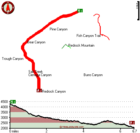
Trailhead 1 to Trailhead 2:
Total hiking length = 6.7 miles
Total climbing distance = 1.6 miles
Difficulty : Difficult
Casual Hiking Pace:
5 hours
Fast Hiking Pace:
3 hours
Trailhead 2 to Trailhead 1:
Total hiking length = 6.7 miles
Total climbing distance = 4.4 miles
Difficulty : Difficult
Casual Hiking Pace:
7 hours
Fast Hiking Pace:
4 hours
| | Trailhead 1 back to Trailhead 1:
Total hiking length = 13.4 miles
Total climbing distance = 6 miles
Difficulty : Difficult
Casual Hiking Pace:
2 days
Fast Hiking Pace:
8 hours
Trailhead 2 back to Trailhead 2:
Total hiking length = 13.4 miles
Total climbing distance = 6 miles
Difficulty : Difficult
Casual Hiking Pace:
2 days
Fast Hiking Pace:
8 hours
|
Total elevation difference: 2480 feet
|


