California hiking trails - Gamboa Trail, Santa Lucia Range, Monterey County

   
  Here in California trekking is always a cool thing to do. Each backpacking and hiking trail in California has its own unique attractiveness. Gamboa Trail is not very close to Salinas at all, but it is an enjoyable place to trek. Hey, time for a trek don’t you think? Gamboa Trail in Monterey County, California is a wonderful pick. There are so many tremendous backpacking and hiking trails for trekking in California, and Gamboa Trail in Monterey County is one of them. Throughout the warmest time of the year highs here at Gamboa Trail get into the 70's while
    nighttime lows are frequently in the 50's. During the wintertime highs are frequently in the 50's while the cold winter nights at Gamboa Trail are in the 40's. Keep in mind that this is a long backcountry hiking trail, so don't forget to pack enough supplies. Please follow all
local rules about fires and camping. This backcountry trek shouldn't take more than 6 hours, but of course some folks walk a bit slower and some a bit faster. This hiking trail goes through some very different elevations, so keep in mind that you may need to dress differently at different elevations. Backcountry trekking here in the Santa Lucia Range is a good way to explore these highlands. Gamboa Trail is 6.6 miles long it's an average length hiking trail. Backcountry trekking here in California is a must. This backpacking and hiking trail has a total  
elevation difference of 1,759 feet which is about average. The amount of rainfall that falls at Gamboa Trail is near the national average; of all the months in a year January is the one with the most rain while July is ordinarily the driest month. Gamboa Trail is a mid-length wilderness trail with an average amount of climbing distance which makes it a glorious hiking trail for experienced walkers in great shape. Gamboa Trail has only one trailhead, so you'll be backcountry hiking it in and back out. This is just one of a large number of hiking trails in this area. This neighborhood does get very dry sometimes, so make sure you check current conditions and fire restrictions with local forest authorities before you head out.

Briefly about the general area:
While you're here at Gamboa Trail you will meet lots of people from nearby Salinas, and drift down the rapids of Arroyo Seco River in a kayak. So much exciting stuff to do here at Gamboa Trail, too great to be true. A trip to nearby Lopez Point is very relaxing.
There's so much to do here at Gamboa Trail that you need to camp here for a while, Goat Campground is a glorious place for that, and if you want a little side spree, try South Fork Devils Canyon. You just ought to go for the Santa Lucia Range. Take a side spree to Limekiln Creek, and get covered with water paddling on Arroyo Seco River. Stay the night at Gamboa Campground, and swing by West Fork Limekiln Creek it's a great spot to stop by.

Location of Trailhead: Latitude 36.0486, Longitude -121.5347
- - Directions and Road Map

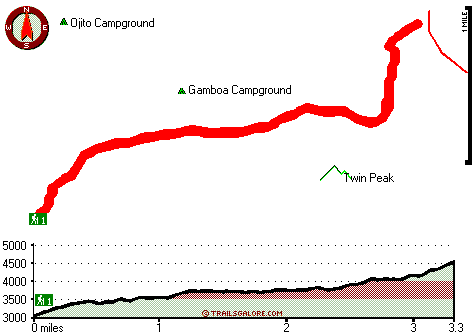
Total in and out hiking length = 6.6 miles

Total climbing distance = 2.7 miles

Difficulty : Difficult

Casual Hiking Pace: 6 hours

Fast Hiking Pace: 3.5 hours

Total elevation difference: 1759 feet


Ventana Inn Big Sur, Big Sur
7 miles away
Situated on 243 acres, 1,200 feet above the Pacific Ocean. The property is known for its serene setting, rustic yet luxurious sophistication and romantic allure. Features include 26 newly remodeled su...
  
Valley Harvest Inn, Soledad
24 miles away
Welcome to the Valley Harvest Inn, located in Soledad, CA, the heart of the Salinas Valley and Monterey County wine country. Close to Pinnacles National Monument, Mission Soledad, and Monterey Bay, th...
User input for Gamboa Trail, Santa Lucia Range, Monterey County, California:

Submit Input:
Your Name:
Write or Paste Input here:

Upload picture:      Review Guidelines


Outdoors Recreation Near Salinas, California
Very comprehensive list of a variety of outdoors recreation in the vicinity of Salinas, California, the metro area neareast to Gamboa Trail. Find info on campgrounds, hiking trails, ski resorts, lakes, beaches, parks, whitewater and more.

Current weather conditions at Gamboa Trail, Santa Lucia Range, Monterey County, California
WXPort

Local climate location: MONTEREY 16 miles away

Quality Inn King City, King City
28 miles away
The Quality Inn features free continental breakfast, free high-speed Internet and an outdoor pool. The rooms have hair dryers, coffee makers, irons and boards and all rooms feature microwaves and refr...

King City Days Inn, King City
28 miles away
Welcome to Days Inn King City where we have 46 beautiful rooms for your convenience. We are conveniently located off Hwy 101 halfway between Los Angeles and San Francisco in the middle of wine country...

More Hotels and Campgrounds Near Gamboa Trail, Santa Lucia Range, Monterey County, California

OTHER_INFO
  Santa Lucia Range Campgrounds
Complete list of all the campgrounds in the Santa Lucia Range.

Santa Lucia Range Outdoors Info
Complete outdoors info for the Santa Lucia Range.

California Hiking Trails
Complete list of all hiking trails in California

Books about hiking trails in California
List of books available on Amazon.com about hiking trails in California.

California Outdoors Index
This is a very comprehensive index of outdoors activities in the great state of California.


TOPO
High quality water resistant topo map of Gamboa Trail, Santa Lucia Range, Monterey County, California.

OUTDOORS_GUIDE
These outdoors activities are available near Gamboa Trail.
 Trails Near Gamboa Trail:
North Coast Ridge Trail, Monterey County , 3 miles away, 9 hiking miles, 1385 feet elevation difference
Girard Trail, Monterey County , 3 miles away, 5.1 hiking miles, 3407 feet elevation difference
Arroyo Seco Trail, Monterey County , 3 miles away,  7.6 hiking miles, 2631 feet elevation difference
Summit Trail, Monterey County , 5 miles away, 1.8 hiking miles, 1522 feet elevation difference
Marble Peak Trail, Monterey County , 9 miles away, 1.6 hiking miles, 1188 feet elevation difference
Hot Springs Trail, Monterey County , 9 miles away,  4.4 hiking miles, 1545 feet elevation difference
Horse Pasture Trail, Monterey County , 10 miles away, 5.3 hiking miles, 1737 feet elevation difference
 Camp Grounds Near Gamboa Trail:
Gamboa Campground, Monterey County, 0 miles away
Goat Campground, Monterey County, 1 miles away
Ojito Campground, Monterey County, 1 miles away
Limekiln State Park, Monterey, 2 miles away
Fresno Campground, Monterey County, 4 miles away
 Whitewater Near Gamboa Trail:
Arroyo Seco River, Monterey County County , 10 miles away, Class IV(V) - 3 miles long (Willowcreek Bridge to Arroyo Seco Picnic Area)
Arroyo Seco River, Monterey County County , 14 miles away, Class III - 14.5 miles long (Arroyo Seco Picnic Area to Route G16 bridge)
San Antonio, Monterey County County , 14 miles away, Class II - 10.7 miles long (Above and down to Mission San Antonio de Padua)
 National Parks Near Gamboa Trail:
Pinnacles National Monument, Paicines - CA , 44 miles away
 Hotels Near Gamboa Trail:
Ventana Inn Big Sur, Big Sur , 7 miles away
Valley Harvest Inn, Soledad , 24 miles away
Quality Inn King City, King City , 28 miles away
King City Days Inn, King City , 28 miles away
Country Garden Inns, Carmel Valley , 28 miles away

Outdoors related information copyright © Stratus-Pikpuk, Inc. - Detailed hotel information copyright © Interactive Hotel Solutions