California hiking trails - Gabrielino National Scenic Trail, San Gabriel Mountains, Los Angeles County

   
  There are so many splendid hiking and backpacking trails for hiking in California, and Gabrielino National Scenic Trail in Los Angeles County is one of them. Finally, hiking time is here again, and Gabrielino National Scenic Trail in Los Angeles County, California is a brilliant site to go. Going for a backcountry trek here in California is so much fun. Of course, this is an overnight hike, 6 days normally, so better have big backpack to fit all the stuff you need. This backpacking and hiking trail is a backpacking and hiking trail of glorious length with
    an average amount of climbing distance which makes this a very tough great outdoors hiking trail for advanced hikers looking for a splendid challenge. Gabrielino National Scenic Trail is quite long, so do pack enough food to last the whole trip. At Gabrielino National Scenic Trail
you don’t see much rain; most of the rain falls during March, and the driest month is July. Every hiking and backpacking trail in California is well worth a backcountry trek. The total elevation difference for Gabrielino National Scenic Trail is 3,843 feet which is higher than average. High temperatures at Gabrielino National Scenic Trail during the summertime months are in the 90's. When the night sets in temperatures descend down into the 60's. Throughout the wintertime highs are generally in the 50's, and overnight lows at Gabrielino National Scenic  
Trail through the wintertime generally descend into the 30's. Please follow all local rules about fires and camping. There are so many great outdoors hiking trails in this neighborhood. While visiting this region in California it's a nice idea to go backcountry backpacking too. This is a two-ended backcountry hiking trail with two trailheads which means you have the option of trekking it one way if you have someone to pick you up at the other end. Gabrielino National Scenic Trail is situated a pretty lengthy journey from Los Angeles-Long Beach-Santa Ana, but many people like to trek here to be near the fresh air. Gabrielino National Scenic Trail is 39.8 miles long; it's considered a longer hike. Backpacking here in the San Gabriel Mountains is the best way to enjoy these summits. This neighborhood does get very dry sometimes, so make sure you check current conditions and fire restrictions with local forest authorities before you head out. Different parts of this great outdoors trail are at very different elevations which of course means you need to be prepared for different conditions on different parts of the great outdoors trail.

Briefly about the general area:
Spruce Grove Campground is a splendid local campground; a short tour to Sturtevant Falls is always worthwhile. So much fun stuff to do here at Gabrielino National Scenic Trail, too great to be true. Some of the water nearby flows, like Trail Fork; if you came for an overnight stay Devore Campground is a delightful spot to camp.
These mountains rock, just check out all the exciting stuff to do in the San Gabriel Mountains. If you desire a little side trip, try Falls Canyon, and Charlton Flat is a perfect place. You just ought to like the San Gabriel Mountains. Rush Creek is a good site to pop by; you'll most likely meet some folks from Los Angeles-Long Beach-Santa Ana here. Doe Spring is an inspiring spot to explore while here; Barley Flats is a good location to check out.
Some magnificent nature is available in Little Gleason Forestry Plantation; you should stop by Twomile Point when you're here.

Location of Trailhead 1: Latitude 34.2211, Longitude -118.178
- - Directions and Road Map

Location of Trailhead 2: Latitude 34.1833, Longitude -118.0189
- - Directions and Road Map


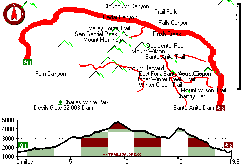
Trailhead 1 to Trailhead 2:
Total hiking length = 19.9 miles
Total climbing distance = 9.1 miles
Difficulty : Difficult
Casual Hiking Pace: 3 days
Fast Hiking Pace: 1.5 days

Trailhead 2 to Trailhead 1:
Total hiking length = 19.9 miles
Total climbing distance = 8.9 miles
Difficulty : Difficult
Casual Hiking Pace: 3 days
Fast Hiking Pace: 1.5 days
    Trailhead 1 back to Trailhead 1:
Total hiking length = 39.8 miles
Total climbing distance = 18 miles
Difficulty : Difficult
Casual Hiking Pace: 6 days
Fast Hiking Pace: 4 days

Trailhead 2 back to Trailhead 2:
Total hiking length = 39.8 miles
Total climbing distance = 18 miles
Difficulty : Difficult
Casual Hiking Pace: 6 days
Fast Hiking Pace: 4 days

Total elevation difference: 3843 feet


Days Inn Pasadena, Pasadena
7 miles away
Value, comfort and convenience have made the Days Inn Pasadena a popular choice for all travelers alike. Located on Colorado Blvd home of the Rose Parade and only minutes away from downtown Pasadena. ...
  
Santa Anita Inn, Arcadia
7 miles away
The Santa Anita Inn has been totally restored to the finest hotel in the San Gabriel Valley. We offer you a resort-like atmosphere (5 1/2 acres of landscaping) in the midst of the city. Our grounds ma...
User input for Gabrielino National Scenic Trail, San Gabriel Mountains, Los Angeles County, California:

Submit Input:
Your Name:
Write or Paste Input here:

Upload picture:      Review Guidelines


Outdoors Recreation Near Los Angeles-Long Beach-Santa Ana, California
Very comprehensive list of a variety of outdoors recreation in the vicinity of Los Angeles-Long Beach-Santa Ana, California, the metro area neareast to Gabrielino National Scenic Trail. Find info on campgrounds, hiking trails, ski resorts, lakes, beaches, parks, whitewater and more.

Current weather conditions at Gabrielino National Scenic Trail, San Gabriel Mountains, Los Angeles County, California
WXPort

Local climate location: PALMDALE 5 miles away

Hilton Garden Inn Arcadia/Pasadena Area, Arcadia
7 miles away
The Hilton Garden Inn Arcadia/Pasadena hotel is conveniently located in the Pasadena area near the Rose Bowl and Santa Anita Race Track. At the Hilton Garden Inn Arcadia/Pasadena hotel in Arcadia Cali...

SpringHill Suites Pasadena Arcadia, Arcadia
7 miles away
Get FREE high-speed Internet access at this SpringHill Suites

Fresh and stylish, the SpringHill Suites by Marriott Arcadia/Pasadena hotel reflects a bright new side of travel. You'll discov...


More Hotels and Campgrounds Near Gabrielino National Scenic Trail, San Gabriel Mountains, Los Angeles County, California

OTHER_INFO
  San Gabriel Mountains Campgrounds
Complete list of all the campgrounds in the San Gabriel Mountains.

San Gabriel Mountains Outdoors Info
Complete outdoors info for the San Gabriel Mountains.

California Hiking Trails
Complete list of all hiking trails in California

Books about hiking trails in California
List of books available on Amazon.com about hiking trails in California.

California Outdoors Index
This is a very comprehensive index of outdoors activities in the great state of California.


TOPO
High quality water resistant topo map of Gabrielino National Scenic Trail, San Gabriel Mountains, Los Angeles County, California.

OUTDOORS_GUIDE
These outdoors activities are available near Gabrielino National Scenic Trail.
 Trails Near Gabrielino National Scenic Trail:
Santa Anita Trail, Los Angeles County , 2 miles away,  4.2 hiking miles, 2891 feet elevation difference
Valley Forge Trail, Los Angeles County , 3 miles away,  3.2 hiking miles, 1606 feet elevation difference
Winter Creek Trail, Los Angeles County , 3 miles away, 3.2 hiking miles, 2924 feet elevation difference
Upper Winter Creek Trail, Los Angeles County , 4 miles away, 4.8 hiking miles, 3976 feet elevation difference
Mount Wilson Trail, Los Angeles County , 4 miles away, 5.6 hiking miles, 4576 feet elevation difference
Idlehour Trail, Los Angeles County , 4 miles away, 6.2 hiking miles, 2028 feet elevation difference
Condor Peak Riding and hiking Trail, Los Angeles County , 11 miles away,  8.6 hiking miles, 3552 feet elevation difference
 Camp Grounds Near Gabrielino National Scenic Trail:
Devore Campground, Los Angeles County, 1 miles away
Spruce Grove Campground, Los Angeles County, 3 miles away
Hoegee Campground, Los Angeles County, 3 miles away
Chilao Campground, Los Angeles County, 4 miles away
Idlehour Campground, Los Angeles County, 4 miles away
 Whitewater Near Gabrielino National Scenic Trail:
Piru Creek, Ventura County County , 51 miles away, Class II - 4 miles long (Lake Piru to Santa Clara River)
Piru Creek, Los Angeles / Ventura County County , 53 miles away, Class IV - 15 miles long (Pyramid Lake to Lake Piru)
Sespe Creek, Ventura County County , 71 miles away, Class IV-V - 31.5 miles long (Lion Campground to Highway 126 bridge)
Santa Margarita River, San Diego County County , 75 miles away, Class IV(V) - 9 miles long (Murrieta Creek to Sandia Creek Road)
 National Parks Near Gabrielino National Scenic Trail:
Santa Monica Mountains National Recreation Area, Thousand Oaks - CA , 57 miles away
 Hotels Near Gabrielino National Scenic Trail:
Days Inn Pasadena, Pasadena , 7 miles away
Santa Anita Inn, Arcadia , 7 miles away
Hilton Garden Inn Arcadia/Pasadena Area, Arcadia , 7 miles away
SpringHill Suites Pasadena Arcadia, Arcadia , 7 miles away
Best Western Pasadena Royale, Pasadena , 7 miles away

Outdoors related information copyright © Stratus-Pikpuk, Inc. - Detailed hotel information copyright © Interactive Hotel Solutions