California hiking trails - Forsee Creek Trail, San Bernardino Mountains, San Bernardino County

   
  Forsee Creek Trail is a long drive away from Riverside-San Bernardino-Ontario, but it is a brilliant backcountry trail. Each wilderness hiking trail in California has its own character. Here in California backcountry hiking is always a cool thing to do. Forsee Creek Trail has only one trailhead, so you're looking at an in and out backcountry walk. Backpacking here in the San Bernardino Mountains is a splendid way to explore these summits. A normal amount of rain falls here at Forsee Creek Trail; through January this vicinity sees the most rain, and
    the driest month of the year is June. This hiking and backpacking trail sometimes gets very dry, so don’t forget to check for any current fire restrictions before you go. There are many good wilderness hiking trails in California; Forsee Creek Trail is one of them, and it's in
San Bernardino County. Don’t forget to check for any current restrictions or closures before you go. This backpacking and hiking trail has a total elevation difference of 3,896 feet which is higher than average. Forsee Creek Trail is quite long, so do pack enough food to last the whole trip. For the period of the summertime, highs generally are in the 80's at Forsee Creek Trail, and during the night it cools down to the 50's. All through the winter highs are usually in the 40's with temperatures at Forsee Creek Trail dipping down into the 20's during winter  
nights. Now, this is roughly a 1.5-day trek, so it's a brilliant thing if your backpack is big enough to do the job. This hiking trail goes through some very different elevations, so keep in mind that you may need to dress differently at different elevations. No chance of getting bored in California if you like the fresh air. The length of Forsee Creek Trail is on the longer side having an average number of uphill miles which makes this a very tough wilderness trail for advanced walkers looking for a tremendous challenge. This is an area covered with lots of wilderness trails. With its 11.8 miles of walking distance; it's considered a longer backcountry trek. Put on your backcountry hiking shoes, and hit the backcountry trail, Forsee Creek Trail in San Bernardino County, California is just the place.

Briefly about the general area:
Yeah, come up here to the San Bernardino Mountains for a brilliant time. This is a popular location for people from Riverside-San Bernardino-Ontario, and a spree to Forsee Creek Trail wouldn't be complete without taking a look at San Y Ca Spring. Forsee Creek Trail is good enough to spend more than a day at, Council Campground is a good local campground, and do explore East Fork Barton Creek if you're here at Forsee Creek Trail.
Be careful coming to the San Bernardino Mountains, you might not ever want to go back home again. San Bernardino National Forest is a glorious local forest. A brilliant place to camp here at Forsee Creek Trail is Camp Mile High Pines, and do set aside some time for Johns Meadow while you're here at Forsee Creek Trail. Frog Creek is a fine spot to have a look at, and don’t forget to go to Anderson Flat if you're here at Forsee Creek Trail.
Forsee Creek Trail truly is in the middle of a pretty outdoors paradise. Staircase Canyon is near Forsee Creek Trail and is a nice site, and a short visit to Trail Fork Springs is always worthwhile.

Location of Trailhead: Latitude 34.1583, Longitude -116.897
- - Directions and Road Map

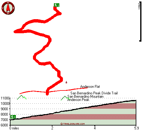
Total in and out hiking length = 11.8 miles

Total climbing distance = 4.9 miles

Difficulty : Difficult

Casual Hiking Pace: 1.5 days

Fast Hiking Pace: 6.5 hours

Total elevation difference: 3896 feet


Hotel de Cortes, Big Bear Lake
5 miles away
Nestled in the majestic San Bernadino mountains and fashioned in the Adirondack style- the Northwoods Resort and Conference center provides the perfect retreat for relaxation- rejuvenation and invigor...
  
Big Bear Lake Cabins, Big Bear Lake
6 miles away
Big Bear Vacations offers over two hundred beautiful Big Bear cabins and vacation rental homes. Cabins are conveniently grouped in three categories- Ski area, Lake or Big Bear Central. All ski cabins ...
User input for Forsee Creek Trail, San Bernardino Mountains, San Bernardino County, California:

Submit Input:
Your Name:
Write or Paste Input here:

Upload picture:      Review Guidelines


Outdoors Recreation Near Riverside-San Bernardino-Ontario, California
Very comprehensive list of a variety of outdoors recreation in the vicinity of Riverside-San Bernardino-Ontario, California, the metro area neareast to Forsee Creek Trail. Find info on campgrounds, hiking trails, ski resorts, lakes, beaches, parks, whitewater and more.

Current weather conditions at Forsee Creek Trail, San Bernardino Mountains, San Bernardino County, California
WXPort

Local climate location: LAKE ARROWHEAD 14 miles away

Snow Lake Lodge, Big Bear
6 miles away
Snow Lake Lodge is located in the Southern California mountains, next to Big Bear lake. Guests enjoy the beauty and splendor of majestic mountain views and clear lake waters. 1.6 km to the city cente...

Golden Bear Cottages, Big Bear Lake
6 miles away
Feel the mountain breeze, see and hear the rustling of the tall pines. Enjoy a personal encounter with nature at Golden Bear Cottages resort. Feel enlightened and serene. Enjoy a lasting sense of peac...

More Hotels and Campgrounds Near Forsee Creek Trail, San Bernardino Mountains, San Bernardino County, California

OTHER_INFO
  San Bernardino Mountains Campgrounds
Complete list of all the campgrounds in the San Bernardino Mountains.

San Bernardino Mountains Outdoors Info
Complete outdoors info for the San Bernardino Mountains.

California Hiking Trails
Complete list of all hiking trails in California

Books about hiking trails in California
List of books available on Amazon.com about hiking trails in California.

California Outdoors Index
This is a very comprehensive index of outdoors activities in the great state of California.


TOPO
High quality water resistant topo map of Forsee Creek Trail, San Bernardino Mountains, San Bernardino County, California.

OUTDOORS_GUIDE
These outdoors activities are available near Forsee Creek Trail.
 Trails Near Forsee Creek Trail:
San Bernardino Peak Divide Trail, San Bernardino County , 1 miles away, 14.4 hiking miles, 5811 feet elevation difference
Falls Creek Trail, San Bernardino County , 2 miles away, 6.2 hiking miles, 5353 feet elevation difference
Dollar Lake Trail, San Bernardino County , 4 miles away, 4.4 hiking miles, 2842 feet elevation difference
South Fork Trail, San Bernardino County , 4 miles away,  3.2 hiking miles, 518 feet elevation difference
Seven Oaks Trail, San Bernardino County , 4 miles away, 1.9 hiking miles, 1761 feet elevation difference
Dry Lake Trail, San Bernardino County , 5 miles away,  9.4 hiking miles, 2270 feet elevation difference
Wilshire Peak Trail, San Bernardino County , 5 miles away,  9.2 hiking miles, 3707 feet elevation difference
 Camp Grounds Near Forsee Creek Trail:
Council Campground, San Bernardino County, 2 miles away
Camp Mile High Pines, Angelus Oaks, 2 miles away
Seven Oaks Lodge, Angelus Oaks, 3 miles away
Oso-Lobo Campground, San Bernardino County, 3 miles away
Falls Recreation Area, San Bernardino County, 4 miles away
 National Parks Near Forsee Creek Trail:
Mojave National Preserve, Barstow - CA , 44 miles away
Joshua Tree National Park, Twentynine Palms - CA , 59 miles away
 Hotels Near Forsee Creek Trail:
Hotel de Cortes, Big Bear Lake , 5 miles away
Big Bear Lake Cabins, Big Bear Lake , 6 miles away
Snow Lake Lodge, Big Bear , 6 miles away
Golden Bear Cottages, Big Bear Lake , 6 miles away
Cozy Hollow Lodge, Big Bear Lake , 6 miles away
 Lakes Near Forsee Creek Trail
Jenks Lake, San Bernardino County , 2 miles away
Dollar Lake, San Bernardino County , 4 miles away

Outdoors related information copyright © Stratus-Pikpuk, Inc. - Detailed hotel information copyright © Interactive Hotel Solutions