California hiking trails - Finger Board Trail, Northern Sierra Nevada, Plumas County

   
  California is a glorious site for backcountry hikers. Spending too much time indoors got you down? No problem, Finger Board Trail in Plumas County, California is just what you need. Backcountry hiking trails are pleasant and plentiful in California, and Finger Board Trail is one of them, and it's in Plumas County. Going for a trek here in California never gets boring. An average amount of precipitation falls at Finger Board Trail; through January this vicinity sees the most snow, and the driest month of the year is July. Some parts of this backcountry
    hiking trail are much higher up than other parts of the backcountry hiking trail, and that means that some parts of the backcountry hiking trail could be very different from other parts of it. Now this backpacking and hiking trail is pretty long, so make sure you bring plenty of
supplies. You should count on this hike taking about 5.5 hours, but you never know stuff could go wrong and you could get stuck so be prepared for that. Being 6.4 miles long it's a mid length hike. Finger Board Trail has only one trailhead, so you'll be backcountry backpacking it in and back out. Finger Board Trail is a normal length backcountry hiking trail having an average number of uphill miles which makes it a good wilderness trail for experienced backcountry trekkers in pleasant shape. Sometimes this backpacking and hiking trail gets really dry,  
so don’t forget to check for any current fire restrictions before you go. There are not too many wilderness trails in this neighborhood. Please follow all local rules about fires and camping. There are numerous great outdoors hiking trails in California, and each one has its own unique attractiveness. Rather far from Truckee-Grass Valley you come upon Finger Board Trail, but if you're looking for a great place to go trekking, this is a great pick. Backcountry hiking trails like this one here in the Northern Sierra Nevada are a very perfect way to see these mountains. Finger Board Trail has a total elevation difference of 3,226 feet which is higher than average. Through the summertime months at Finger Board Trail temperatures are mostly in the 80's, and through the night it cools down to the 40's. During the winter highs are in the 30's with temperatures at Finger Board Trail dipping down into the 20's through winter nights.

Briefly about the general area:
If you don’t have a problem getting drenched, you can always go whitewater paddling on Feather River - Middle Fork; do put some time aside to spend at Lost Cabin Spring since you're here at Finger Board Trail. You completely ought to go for Finger Board Trail. Don’t forget to stop at Sawpit Flat if you're here at Finger Board Trail, and Minerva Bar is a glorious spot to spend some time.
You'll need more than a day to look at everything Finger Board Trail has to offer, you can camp at Big Cove - Plumas National Forest; Quartz Point is very near and is a perfect location to visit. Washington Creek is a stream that you may encounter while here, and you can stay the night at Pioneer RV Park. And if that's not enough there's plenty more cool stuff to do in the Northern Sierra Nevada. There's some flowing water nearby, Bachs Creek is a stream you can pop by while here, and Monitor Flat is a magnificent location here at Finger Board Trail.
Now, you may imagine that's plenty but there's even more fun stuff to do here in the Northern Sierra Nevada.

Location of Trailhead: Latitude 39.8181, Longitude -120.902
- - Directions and Road Map

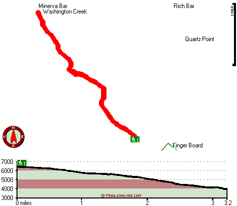
Total in and out hiking length = 6.4 miles

Total climbing distance = 2.5 miles

Difficulty : Difficult

Casual Hiking Pace: 5.5 hours

Fast Hiking Pace: 3.5 hours

Total elevation difference: 3226 feet


Chalet View Lodge, Graeagle
25 miles away
  
Deer Creek Inn, Nevada City
26 miles away
Deer Creek Inn is a 150 year old restored Queen Anne Victorian located in the historic Gold Rush town of Nevada City, California. The historic shopping and dining district on Broad Street is only foot...
User input for Finger Board Trail, Northern Sierra Nevada, Plumas County, California:

Submit Input:
Your Name:
Write or Paste Input here:

Upload picture:      Review Guidelines


Outdoors Recreation Near Truckee-Grass Valley, California
Very comprehensive list of a variety of outdoors recreation in the vicinity of Truckee-Grass Valley, California, the metro area neareast to Finger Board Trail. Find info on campgrounds, hiking trails, ski resorts, lakes, beaches, parks, whitewater and more.

Current weather conditions at Finger Board Trail, Northern Sierra Nevada, Plumas County, California
WXPort

Local climate location: CANYON DAM 17 miles away

Nevada City Inn, Nevada City
31 miles away
A home away from home! Comfortable, park-like setting, 2/3 of a mile to downtown Nevada City, 27 guest rooms inluding 7 cottages. We are now an all non smoking room hotel. We are a pet friendly hotel...

Piety Hill Cottages, Nevada City
31 miles away
9 Tastefully appointed BnB cottages in this parklike setting 1 acre with tree-shaded grassy courtyard...

More Hotels and Campgrounds Near Finger Board Trail, Northern Sierra Nevada, Plumas County, California

OTHER_INFO
  Northern Sierra Nevada Campgrounds
Complete list of all the campgrounds in the Northern Sierra Nevada.

Northern Sierra Nevada Outdoors Info
Complete outdoors info for the Northern Sierra Nevada.

California Hiking Trails
Complete list of all hiking trails in California

Books about hiking trails in California
List of books available on Amazon.com about hiking trails in California.

California Outdoors Index
This is a very comprehensive index of outdoors activities in the great state of California.


TOPO
High quality water resistant topo map of Finger Board Trail, Northern Sierra Nevada, Plumas County, California.

OUTDOORS_GUIDE
These outdoors activities are available near Finger Board Trail.
 Trails Near Finger Board Trail:
Claremont Trail, Plumas County , 4 miles away, 2.3 hiking miles, 1051 feet elevation difference
Cleghorn Bar Trail, Plumas County , 6 miles away,  6 hiking miles, 2074 feet elevation difference
Eureka Lake Trail, Plumas County , 14 miles away, 1.4 hiking miles, 1203 feet elevation difference
 Camp Grounds Near Finger Board Trail:
Pioneer RV Park, Quincy, 6 miles away
Big Cove - Plumas National Forest, Quincy, 6 miles away
Boulder Creek - Plumas National Forest, Quincy, 6 miles away
Grasshopper Flat - Plumas National Forest, Quincy, 6 miles away
Lakes Basin - Plumas National Forest, Quincy, 6 miles away
 Whitewater Near Finger Board Trail:
Feather River - Middle Fork, Plumas County County , 9 miles away, Class II-III - 6.5 miles long (Sloat to Nelson Point)
Feather River - Middle Fork, Plumas/ Butte County County , 11 miles away, Class V+ - 32.5 miles long (Nelson Point to Milsap Bridge)
Indian Creek Feather Tributary, Plumas County County , 12 miles away, Class V - 5.5 miles long (Close to Crescent Mills to Spanish Creek)
Feather River - South Fork, Plumas County County , 13 miles away, Class IV - 8.3 miles long (Little Grass Valley Reservoir to South Fork Diversion Dam)
Lavezzola Creek, Sierra County County , 15 miles away, Class IV(V) - 4 miles long (2nd Divide Bridge to Downieville)
 National Parks Near Finger Board Trail:
Lassen Volcanic National Park, Mineral - CA , 53 miles away
 Hotels Near Finger Board Trail:
Chalet View Lodge, Graeagle , 25 miles away
Deer Creek Inn, Nevada City , 26 miles away
Nevada City Inn, Nevada City , 31 miles away
Piety Hill Cottages, Nevada City , 31 miles away
Best Western Gold Country Inn, Grass Valley , 33 miles away
 Lakes Near Finger Board Trail
Delahunty Lake, Plumas County , 5 miles away

Outdoors related information copyright © Stratus-Pikpuk, Inc. - Detailed hotel information copyright © Interactive Hotel Solutions