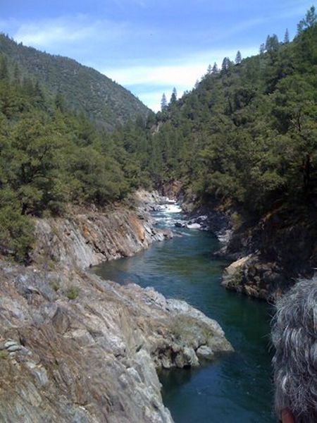
California hiking trails - Euchre Bar Trail, Northern Sierra Nevada, Placer County

   
  While visiting this area in California it's a fine idea to go backcountry trekking too. There are so many great backcountry hiking trails for backcountry trekking in California, and Euchre Bar Trail in Placer County is one of them. It's a long trip from Truckee-Grass Valley to Euchre Bar Trail, but it sure is a a fine great outdoors hiking trail. This neighborhood does get very dry sometimes, so do check for current fire restrictions before you go if you plan to bring a stove or make a camp fire. Euchre Bar Trail gets a good deal of water; the wettest
    month of the year is ordinarily January, that's the one that rains the most, and the driest month is July. Don’t forget to check for any current restrictions or closures before you go. There are numerous backcountry hiking trails in California, and each one has something unique
to offer. At Euchre Bar Trail during the months of summer highs are in the 90's. When the night sets in temperatures descend down into the 60's. High temperatures during the winter are normally in the 50's, and nighttime lows in the 30's for Euchre Bar Trail. This backpacking trail has two trailheads, so backcountry backpacking it one way is an option if you can arrange for a ride back. There are so many hiking trails in this area. Euchre Bar Trail is a mid-length great outdoors hiking trail with an average amount of climbing distance which makes it a glorious  
hiking trail for experienced hikers in delightful shape. The total elevation difference for this backpacking trail is 1,947 feet which is an average number. Wilderness hiking trails like this one here in the Northern Sierra Nevada are a fine way to explore these highlands. Hey, time for a backcountry walk don’t you think? Euchre Bar Trail in Placer County, California is the outdoors at its best. Euchre Bar Trail is 6.6 miles long it's a mid length backcountry walk. Here in California backcountry trekking is an excellent idea. Euchre Bar Trail is quite long, so make sure you bring plenty of supplies. You should count on this backcountry hike taking about 5.5 hours, but of course some people walk a bit slower and some a bit faster. This great outdoors trail goes through some very different elevations, and that means that some parts of the great outdoors trail could be very different from other parts of it.

Briefly about the general area:
Goat Spring is always fun to check out. There's so much to do here at Euchre Bar Trail that you need to camp here for a while, Monzarita Day Use Campground is a great spot for that. You'll meet a lot of people from Truckee-Grass Valley here, and some of the water nearby flows, like Humbug Creek.
You clearly should have a thing about the Northern Sierra Nevada. Do set aside some time for Elliot Meadow if you're here at Euchre Bar Trail, and you can run the rapids of American River - North Fork. Do schedule some time to visit Iron Point in the vicinity of Euchre Bar Trail if you have a chance; you can stay the night at Baxter RV Campground. Having a great time at Euchre Bar Trail is painless. A good spot to have a look at near Euchre Bar Trail is Euchre Bar, and if you're looking for some flowing water? Try North Fork North Fork American River.
Man, is there heaps of exciting stuff to do in the Northern Sierra Nevada.

Location of Trailhead 1: Latitude 39.1935, Longitude -120.7699
- - Directions and Road Map

Location of Trailhead 2: Latitude 39.1772, Longitude -120.7277
- - Directions and Road Map


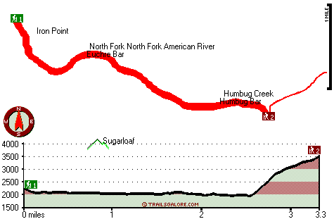
Trailhead 1 to Trailhead 2:
Total hiking length = 3.3 miles
Total climbing distance = 1.4 miles
Difficulty : Medium
Casual Hiking Pace: 3 hours
Fast Hiking Pace: 1.5 hours

Trailhead 2 to Trailhead 1:
Total hiking length = 3.3 miles
Total climbing distance = 1 miles
Difficulty : Easy
Casual Hiking Pace: 2.5 hours
Fast Hiking Pace: 1.5 hours
    Trailhead 1 back to Trailhead 1:
Total hiking length = 6.6 miles
Total climbing distance = 2.4 miles
Difficulty : Difficult
Casual Hiking Pace: 5.5 hours
Fast Hiking Pace: 3.5 hours

Trailhead 2 back to Trailhead 2:
Total hiking length = 6.6 miles
Total climbing distance = 2.4 miles
Difficulty : Difficult
Casual Hiking Pace: 5.5 hours
Fast Hiking Pace: 3.5 hours

Total elevation difference: 1947 feet


Deer Creek Inn, Nevada City
12 miles away
Deer Creek Inn is a 150 year old restored Queen Anne Victorian located in the historic Gold Rush town of Nevada City, California. The historic shopping and dining district on Broad Street is only foot...
  
Nevada City Inn, Nevada City
19 miles away
A home away from home! Comfortable, park-like setting, 2/3 of a mile to downtown Nevada City, 27 guest rooms inluding 7 cottages. We are now an all non smoking room hotel. We are a pet friendly hotel...
User input for Euchre Bar Trail, Northern Sierra Nevada, Placer County, California:

Submit Input:
Your Name:
Write or Paste Input here:

Upload picture:      Review Guidelines


Outdoors Recreation Near Truckee-Grass Valley, California
Very comprehensive list of a variety of outdoors recreation in the vicinity of Truckee-Grass Valley, California, the metro area neareast to Euchre Bar Trail. Find info on campgrounds, hiking trails, ski resorts, lakes, beaches, parks, whitewater and more.

Current weather conditions at Euchre Bar Trail, Northern Sierra Nevada, Placer County, California
WXPort

Local climate location: COLFAX 13 miles away

Piety Hill Cottages, Nevada City
20 miles away
9 Tastefully appointed BnB cottages in this parklike setting 1 acre with tree-shaded grassy courtyard...

Best Western Gold Country Inn, Grass Valley
20 miles away
**Hot tub closed until further notice.** Discover this pet friendly Grass Valley, California hotel offering convenient access to Empire Mine State Park, Historic Nevada City and the Tahoe National Fo...

More Hotels and Campgrounds Near Euchre Bar Trail, Northern Sierra Nevada, Placer County, California

OTHER_INFO
  Northern Sierra Nevada Campgrounds
Complete list of all the campgrounds in the Northern Sierra Nevada.

Northern Sierra Nevada Outdoors Info
Complete outdoors info for the Northern Sierra Nevada.

California Hiking Trails
Complete list of all hiking trails in California

Books about hiking trails in California
List of books available on Amazon.com about hiking trails in California.

California Outdoors Index
This is a very comprehensive index of outdoors activities in the great state of California.


TOPO
High quality water resistant topo map of Euchre Bar Trail, Northern Sierra Nevada, Placer County, California.

OUTDOORS_GUIDE
These outdoors activities are available near Euchre Bar Trail.
 Trails Near Euchre Bar Trail:
American Eagle Trail, Placer County , 2 miles away,  1.8 hiking miles, 190 feet elevation difference
Green Valley Trail, Placer County , 3 miles away, 2.8 hiking miles, 2371 feet elevation difference
Italian Bar Trail, Placer County , 5 miles away,  4 hiking miles, 2437 feet elevation difference
Burnett Canyon Trail, Placer County , 7 miles away, 1.1 hiking miles, 753 feet elevation difference
Bake Oven Trail, Placer County , 8 miles away,  9 hiking miles, 2032 feet elevation difference
Mumford Bar Trail, Placer County , 8 miles away, 5.1 hiking miles, 3289 feet elevation difference
Eagle Bird Trail, Nevada County , 9 miles away, 1.6 hiking miles, 1371 feet elevation difference
 Camp Grounds Near Euchre Bar Trail:
Baxter RV Campground, Alta, 3 miles away
Monzarita Day Use Campground, Placer County, 4 miles away
Forbes Campground, Placer County, 4 miles away
Chicken Hawk Campground, Placer County, 5 miles away
Dutch Flat RV Resort, Gold Run, 6 miles away
 Whitewater Near Euchre Bar Trail:
American River - North Fork, Placer County County , 6 miles away, Class IV-V - 12.3 miles long (Tadpole Creek to Euchre Bar)
American River - North Fork, Placer County County , 7 miles away, Class IV-V - 14.5 miles long (Euchre Bar to Colfax-Iowa Hill Road)
American River - Middle Fork, Placer County County , 9 miles away, Class IV-V - 2.1 miles long (Mosquito Ridge Road to confluence with Middle Fork)
Yuba River - South Fork, Nevada/ Placer County County , 13 miles away, Class IV-V(V+) - 7.5 miles long (Cisco Grove to Spaulding Reservoir)
Yuba River - South Fork, Nevada County County , 13 miles away, Class IV - 14 miles long (Washington to Edwards Crossing)
 Hotels Near Euchre Bar Trail:
Deer Creek Inn, Nevada City , 12 miles away
Nevada City Inn, Nevada City , 19 miles away
Piety Hill Cottages, Nevada City , 20 miles away
Best Western Gold Country Inn, Grass Valley , 20 miles away
Holiday Lodge Grass Valley, Grass Valley , 21 miles away
 Lakes Near Euchre Bar Trail
Sugar Pine Reservoir, Placer County , 4 miles away

Outdoors related information copyright © Stratus-Pikpuk, Inc. - Detailed hotel information copyright © Interactive Hotel Solutions