California hiking trails - Emerson Creek Trail, Warner Mountains, Modoc County

   
  My children were born and raised her in alturas, the family name warren goes back for at least 150 years ther is a mountain peek named after the family. Warren Peek Says Nancy Warren

Every California trail has its own unique prettiness. California has so much to offer the great outdoors lovers. Here in the glorious state of California trekking is so much fun. This is a one trailhead great outdoors hiking trail, so in and out is the way to hike it normally. The delightful hiking trails of the Warner Mountains are the best way to enjoy these highlands.
    Some parts of Emerson Creek Trail are much higher up than other parts of the wilderness hiking trail, so keep in mind that you may need to dress differently at different elevations. With its 7 miles of walking distance it's an average length wilderness hiking trail. The time needed
for this backcountry trek is roughly 6 hours, but you never know stuff could go wrong and you could get stuck so be prepared for that. Emerson Creek Trail is very far from the closest good size urban center, and backcountry trekking it is always fun. Through the long summer days highs here at Emerson Creek Trail get into the 80's, and through summer nights temperatures are in the 40's. During the winter highs are in the 40's, and winter nights come with lows in the 10's to Emerson Creek Trail. This hiking trail is a normal length hiking trail with an average  
amount of climbing distance which makes this wilderness trail great for hard core backpackers looking for adventure. Don’t forget to check for any current restrictions or closures before you go. Emerson Creek Trail gets very little precipitation; the month with most of the rain is November; the driest month of the year is July. Sometimes this backcountry hiking trail gets really dry, so do check for current fire restrictions before you go if you plan to bring a stove or make a camp fire. The total elevation difference for Emerson Creek Trail is 2,630 feet, and that is higher than average. This is an area covered with lots of wilderness trails. Keep in mind that this is a long backcountry hiking trail, so don't forget to pack enough supplies. We all need to get out in the outdoors once in a while, and Emerson Creek Trail in Modoc County, California is a perfect spot for getting out. Good trails in California are in abundance, and Emerson Creek Trail in Modoc County is one of them.

Briefly about the general area:
Camping is available at Soup Spring Campground, and why not take a little journey to South Fork Emerson Creek if you're here. If you came for an overnight stay Blue Lake Campground is a splendid place to camp. If you want a glorious time in the great outdoors just come on up to the Warner Mountains. Don’t forget to pop by Bearcamp Flat since you're here at Emerson Creek Trail, and North Fork Emerson Creek is near Emerson Creek Trail and is always a joy to check out.

Location of Trailhead: Latitude 41.2626, Longitude -120.1397
- - Directions and Road Map

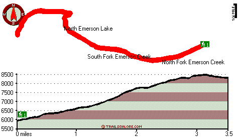
Total in and out hiking length = 7 miles

Total climbing distance = 3 miles

Difficulty : Difficult

Casual Hiking Pace: 6 hours

Fast Hiking Pace: 4 hours

Total elevation difference: 2630 feet


Best Western Trailside Inn, Alturas
29 miles away
Here in Modoc county, surrounding the Best Western Trailside Inn in Alturas, is the history of the American west. From the days of discovery and exploration to the glory structures of another generat...
  
Super 8 Alturas, Alturas
29 miles away
* AAA approved/2 Diamonds. Superstart Breakfast, high speed wireless and wired internet access, microwaves/refrigerators, hairdryers, cable TV w/HBO, ESPN, suites available. Golf Course 1 mile, Ski Ar...
User input for Emerson Creek Trail, Warner Mountains, Modoc County, California:

Submit Input:
Your Name:
Write or Paste Input here:

Upload picture:      Review Guidelines


Outdoors Recreation Near Reno-Sparks, Nevada
Very comprehensive list of a variety of outdoors recreation in the vicinity of Reno-Sparks, Nevada, the metro area neareast to Emerson Creek Trail. Find info on campgrounds, hiking trails, ski resorts, lakes, beaches, parks, whitewater and more.

Current weather conditions at Emerson Creek Trail, Warner Mountains, Modoc County, California
WXPort

Local climate location: JESS VALLEY 5 miles away

Budget Inn - Lakeview, Lakeview
50 miles away
Conveniently located just one block from the intersection of Highway 395 and Highway 140. The Budget Inn-Lakeview is located in nice quiet location, next to a restaurant, and is also within easy walki...

Best Western Skyline Motor Lodge, Lakeview
50 miles away
This pet friendly Lakeview, Oregon hotel provides convenient access to the Hart Mountain Antelope Refuge, the Old Perpetual Geyser and the Warner Mountain Ski area. Whether traveling to Southeast Or...

More Hotels and Campgrounds Near Emerson Creek Trail, Warner Mountains, Modoc County, California

OTHER_INFO
  Warner Mountains Campgrounds
Complete list of all the campgrounds in the Warner Mountains.

Warner Mountains Outdoors Info
Complete outdoors info for the Warner Mountains.

California Hiking Trails
Complete list of all hiking trails in California

Books about hiking trails in California
List of books available on Amazon.com about hiking trails in California.

California Outdoors Index
This is a very comprehensive index of outdoors activities in the great state of California.


TOPO
High quality water resistant topo map of Emerson Creek Trail, Warner Mountains, Modoc County, California.

OUTDOORS_GUIDE
These outdoors activities are available near Emerson Creek Trail.
 Trails Near Emerson Creek Trail:
Bearcamp Flat Trail, Modoc County , 2 miles away, 1.1 hiking miles, 527 feet elevation difference
East Creek Trail, Modoc County , 3 miles away, 7.5 hiking miles, 2136 feet elevation difference
Poison Flat Trail, Modoc County , 5 miles away,  5.2 hiking miles, 1721 feet elevation difference
Pine Creek Trail, Modoc County , 7 miles away,  8.6 hiking miles, 2881 feet elevation difference
Owl Creek Trail, Modoc County , 8 miles away, 12.5 hiking miles, 4124 feet elevation difference
 Camp Grounds Near Emerson Creek Trail:
Soup Spring Campground, Modoc County, 8 miles away
Blue Lake Campground, Lassen County, 10 miles away
Little Meadows Campground, Modoc County, 14 miles away
Likely Place Recreational Vehicle Park & Golf, Likely, 16 miles away
Stough Campground, Modoc County, 17 miles away
 Hotels Near Emerson Creek Trail:
Best Western Trailside Inn, Alturas , 29 miles away
Super 8 Alturas, Alturas , 29 miles away
Budget Inn - Lakeview, Lakeview , 50 miles away
Best Western Skyline Motor Lodge, Lakeview , 50 miles away
Fremont Inn, Lakeview , 50 miles away

Outdoors related information copyright © Stratus-Pikpuk, Inc. - Detailed hotel information copyright © Interactive Hotel Solutions