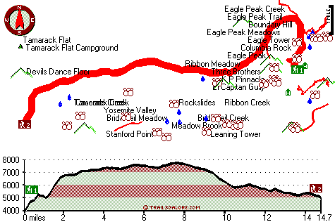
California hiking trails - El Capitan Trail, Central Sierra Nevada, Mariposa County

   
  It's a lengthy trip from Madera to El Capitan Trail, but trekking is such an enjoyable thing to do, and this is a good location to do that. Put on your trekking shoes, and hit the backpacking trail, El Capitan Trail in Mariposa County, California is a good location to go. California is a magnificent location for outdoors people. Going for a backcountry walk here in California is always a fun thing to do. Great outdoors hiking trails are great and plentiful in California, and El Capitan Trail in Mariposa County is one of them. Different parts of this great
    outdoors hiking trail are at very different elevations, and that means that some parts of the great outdoors hiking trail could be very different from other parts of it. This is one of many backpacking and hiking trails in the surrounding region. These wilderness hiking trails
here in the Central Sierra Nevada are a very good way to see these hills. With its 29.4 miles of walking distance; it's a long great outdoors hiking trail. Each one of the many backpacking and hiking trails of California has its own unique splendor. This area does get very dry sometimes, so make sure you check current conditions and fire restrictions with local forest authorities before you head out. Please follow all local rules about fires and camping. El Capitan Trail is a very long wilderness hiking trail having an average number of uphill miles  
which makes it a great backpacking and hiking trail for experienced trekkers in good shape. At El Capitan Trail through the long summer days highs are in the 80's. Once the sun is down it sinks down to the 50's. For the period of the winter this place gets highs in the 40's while El Capitan Trail nighttime low temperatures through the winter are in the 20's. This trek should take you about 4.5 days, so make sure you've got all your overnight gear packed. The high level of rainfall makes El Capitan Trail a reasonably wet place; most of the rain falls through January, and the driest month is July. This is a backcountry hiking trail that is quite long, so do pack enough food to last the whole trip. This hiking and backpacking trail has two trailheads, so if you can get a ride from someone, you can backcountry hike it just one way. The total elevation difference for this hiking and backpacking trail is 4,758 feet which is a higher than average number.

Briefly about the general area:
Why not have a look at close by Bridalveil Creek while you're here at El Capitan Trail. Cascade Dam is not far at all from El Capitan Trail, and don't leave El Capitan Trail without first paying a visit to Black Spring.
Everybody loves Bridalveil Meadow, and Yosemite National Park is a great national park. Whohoo, so many exciting things in one place! El Capitan Trail is excellent! Get drenched paddling on Merced River, and El Capitan Trail is tremendous enough to spend more than a day at, Tamarack Flat Campground is a tremendous local campground. That right there is a load of amusing things already but it goes on, the Central Sierra Nevada has it all. Glide down the rapids of Yosemite Creek in a kayak; Ribbon Fall is an inspiring site to have a look at during your stay.
If you came to camp Bridalveil Campground is a great place to do that; why not take a look at Casa Diablo also while you're here. You'll really wish for more hours in a day to enjoy all the enjoyable stuff in the Central Sierra Nevada. A visit to Ribbon Meadow rejuvenates the soul, and a fine place nearby is El Capitan Gully. Tuolumne Grove is a wonderful forest region close to El Capitan Trail; it's a tremendous idea to take a look at Meadow Brook.

Location of Trailhead 1: Latitude 37.741, Longitude -119.602
- - Directions and Road Map

Location of Trailhead 2: Latitude 37.7144, Longitude -119.7341
- - Directions and Road Map


Trailhead 1 to Trailhead 2:
Total hiking length = 14.7 miles
Total climbing distance = 5.8 miles
Difficulty : Difficult
Casual Hiking Pace: 2 days
Fast Hiking Pace: 7 hours

Trailhead 2 to Trailhead 1:
Total hiking length = 14.7 miles
Total climbing distance = 7 miles
Difficulty : Difficult
Casual Hiking Pace: 2.5 days
Fast Hiking Pace: 7.5 hours
    Trailhead 1 back to Trailhead 1:
Total hiking length = 29.4 miles
Total climbing distance = 12.8 miles
Difficulty : Difficult
Casual Hiking Pace: 4.5 days
Fast Hiking Pace: 3 days

Trailhead 2 back to Trailhead 2:
Total hiking length = 29.4 miles
Total climbing distance = 12.8 miles
Difficulty : Difficult
Casual Hiking Pace: 4.5 days
Fast Hiking Pace: 3 days

Total elevation difference: 4758 feet


dnc -- Wawona Hotel, Yosemite National Park
5 miles away
Wawona is one of the oldest mountain resort hotels in California and a National Historic Landmark. Its verdant meadows, rushing streams, and tranquility make this a favorite of those who prefer a rela...
  
Yosemite Lodge at the Falls, Yosemite National Park
5 miles away
As the closest property to Yosemite Falls, Yosemite Lodge is an idyllic spot for families, group retreats and visitors seeking to blend the comforts of a hotel while exploring the wilderness. In 1998,...
User input for El Capitan Trail, Central Sierra Nevada, Mariposa County, California:

Submit Input:
Your Name:
Write or Paste Input here:

Upload picture:      Review Guidelines


Outdoors Recreation Near Madera, California
Very comprehensive list of a variety of outdoors recreation in the vicinity of Madera, California, the metro area neareast to El Capitan Trail. Find info on campgrounds, hiking trails, ski resorts, lakes, beaches, parks, whitewater and more.

Current weather conditions at El Capitan Trail, Central Sierra Nevada, Mariposa County, California
WXPort

Local climate location: CHERRY VALLEY DAM 11 miles away

dnc -- Housekeeping Camp, Yosemite National Park
5 miles away
Housekeeping Camp is located along a section of the Merced River in the center of Yosemite Valley. This is the ideal location for those who like to camp outdoors without the bother of setting up a ten...

Ahwahnee Hotel, Yosemite National Park
5 miles away
As a National Historical Landmark and one of the most distinctive resort hotels in North America, The Ahwahnee is well known for its great granite faade, striking beamed ceilings, massive stone hearth...

More Hotels and Campgrounds Near El Capitan Trail, Central Sierra Nevada, Mariposa County, California

OTHER_INFO
  Central Sierra Nevada Campgrounds
Complete list of all the campgrounds in the Central Sierra Nevada.

Central Sierra Nevada Outdoors Info
Complete outdoors info for the Central Sierra Nevada.

California Hiking Trails
Complete list of all hiking trails in California

Books about hiking trails in California
List of books available on Amazon.com about hiking trails in California.

California Outdoors Index
This is a very comprehensive index of outdoors activities in the great state of California.


TOPO
High quality water resistant topo map of El Capitan Trail, Central Sierra Nevada, Mariposa County, California.

OUTDOORS_GUIDE
These outdoors activities are available near El Capitan Trail.
 Trails Near El Capitan Trail:
Pohono Trail, Mariposa County , 2 miles away, 11.4 hiking miles, 3527 feet elevation difference
Eagle Peak Trail, Mariposa County , 4 miles away,  9.4 hiking miles, 3939 feet elevation difference
Hetch Hetchy Trail, Mariposa County , 4 miles away, 7.7 hiking miles, 3804 feet elevation difference
Yosemite Falls Trail, Mariposa County , 4 miles away,  9.4 hiking miles, 3958 feet elevation difference
Four Mile Trail, Mariposa County , 5 miles away, 3.7 hiking miles, 3869 feet elevation difference
North Dome Trail, Mariposa County , 6 miles away, 14.4 hiking miles, 4985 feet elevation difference
Buena Vista Trail, Madera County , 7 miles away,  22.4 hiking miles, 2797 feet elevation difference
 Camp Grounds Near El Capitan Trail:
Bridalveil Campground, Mariposa County, 5 miles away
Tamarack Flat Campground, Mariposa County, 5 miles away
Smoky Jack Campground, Tuolumne County, 6 miles away
Lower River Campground, Mariposa County, 6 miles away
Upper River Campground, Mariposa County, 6 miles away
 Whitewater Near El Capitan Trail:
Merced River, Mariposa County County , 4 miles away, Class V - 4.8 miles long (Routes 120-140 Junction to Arch Rock Entrance Station)
Yosemite Creek, Mariposa County County , 6 miles away, Class IV-V - 8 miles long (Tioga Pass Road to Yosemite Falls)
Tuolumne River, Tuolumne County County , 11 miles away, Class IV-V+ - 32 miles long (Tioga Road Bridge to Hetch Hetchy Reservoir)
Big Creek, Mariposa County County , 12 miles away, Class IV-V+ - 1 miles long (Chowchilla Mountain Road to South Fork Merced River)
Tenaya Creek, Mariposa County County , 12 miles away, Class V - 1 miles long (Super Slide)
 National Parks Near El Capitan Trail:
Yosemite National Park, Yosemite National Park - CA , 9 miles away
Devils Postpile National Monument, Mammoth Lakes - CA , 64 miles away
 Hotels Near El Capitan Trail:
dnc -- Wawona Hotel, Yosemite National Park , 5 miles away
Yosemite Lodge at the Falls, Yosemite National Park , 5 miles away
dnc -- Housekeeping Camp, Yosemite National Park , 5 miles away
Ahwahnee Hotel, Yosemite National Park , 5 miles away
Curry Village, Yosemite National Park , 5 miles away

Outdoors related information copyright © Stratus-Pikpuk, Inc. - Detailed hotel information copyright © Interactive Hotel Solutions