| |
Made it to the trailhead, but there was a No trespassingĀ sign and a locked chain across the trail. Says Thomas
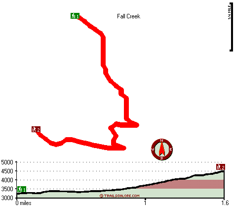
Eagle Bird Trail has a total elevation difference of 1,371 feet which is an average number. Sometimes this great outdoors trail gets really dry, so make sure you check current conditions and fire restrictions with local forest authorities before you head out. Being 3.2 miles long it's a shorter type backcountry walk. The time needed for this trek is roughly 2.5 hours, but you never know stuff could go wrong and you could get stuck so be prepared for that. Eagle Bird Trail has two trailheads, so backcountry backpacking it one way is an option if you can arrange for a ride back. Even though this is not a very long great outdoors trail you should still bring some emergency supplies just in case something happens. There's not much difference in elevation along Eagle Bird Trail which means the conditions are about the same from start to finish.
|
Trailhead 1 to Trailhead 2:
Total hiking length = 1.6 miles
Total climbing distance = 1.1 miles
Difficulty : Medium
Casual Hiking Pace:
1.5 hours
Fast Hiking Pace:
1 hours
Trailhead 2 to Trailhead 1:
Total hiking length = 1.6 miles
Total climbing distance = .1 miles
Difficulty : Easy
Casual Hiking Pace:
1 hours
Fast Hiking Pace:
.5 hours
| | Trailhead 1 back to Trailhead 1:
Total hiking length = 3.2 miles
Total climbing distance = 1.2 miles
Difficulty : Medium
Casual Hiking Pace:
2.5 hours
Fast Hiking Pace:
1.5 hours
Trailhead 2 back to Trailhead 2:
Total hiking length = 3.2 miles
Total climbing distance = 1.2 miles
Difficulty : Medium
Casual Hiking Pace:
2.5 hours
Fast Hiking Pace:
1.5 hours
|
Total elevation difference: 1371 feet
|


