California hiking trails - Don Cecil Trail, Southern Sierra Nevada, Fresno County

   
  Ok, you've been cooped up too long, time to get out in the fresh air a bit, and Don Cecil Trail in Fresno County, California is just what you need. Every hiking trail in California is worth backpacking. California is a tremendous outdoors state. If you happen to be in California, why not go backpacking, it is always an enjoyable thing to do. There are many nice hiking trails in California, and one of these is Don Cecil Trail in Fresno County. Don Cecil Trail is quite long, so make sure you bring plenty of supplies. Backcountry backpacking here in the Southern
    Sierra Nevada is a very pleasant way to see these mountains. From a rain point of view Don Cecil Trail is a pretty common place; the month with most of the rain is January while July is commonly the driest month. Some parts of Don Cecil Trail are much higher up than other parts
of the trail, and that means that some parts of the trail could be very different from other parts of it. This backcountry trek shouldn't take more than 8.5 hours, but of course some folks walk a bit slower and some a bit faster. Please follow all local rules about fires and camping. The number of wilderness hiking trails in this vicinity is not very high. Don Cecil Trail has a total elevation difference of 3,586 feet, and that is higher than average. Don Cecil Trail is not very in the vicinity of Visalia-Porterville at all, but when you walk it you're always  
having a fine time. Through the summer months at Don Cecil Trail temperatures are mostly in the 70's, and during summer nights temperatures are in the 50's. The winter brings highs down to the 40's with temperatures at Don Cecil Trail dipping down into the 20's during winter nights. There are two trailheads to chose from, one in each end, so backcountry hiking it one way is an option if you can arrange for a ride back. This wilderness trail is many miles long with an average amount of climbing distance which makes it a splendid wilderness hiking trail for experienced walkers in great shape. With its 9.6 miles of walking distance; it's longer than many trails. This area does get very dry sometimes, so don’t forget to check for any current fire restrictions before you go.

Briefly about the general area:
Man, is there heaps of entertaining stuff to do in the Southern Sierra Nevada. There's so much to do here at Don Cecil Trail that you need to camp here for a while, Sentinel Campground is a delightful place for that; a splendid location like Summit Meadow here at Don Cecil Trail is too good to miss. Roaring River Falls is a beautiful place to take a look at while you're at Don Cecil Trail; Sequoia & Kings Canyon National Park is a perfect spot nearby.
Stay the night at Sheep Creek Campground, and if you come at the right time of year, Kings River - Middle Fork offers some glorious whitewater. So much cool stuff to do here in the Southern Sierra Nevada, too delightful to be true. Some nearby water includes Hotel Creek. If you want a delightful time in the great outdoors, just come on down to Don Cecil Trail. Sheep Creek is one of the streams close by that might be worth a visit, and don’t forget to visit Williams Meadow if you're here at Don Cecil Trail.
Whitewater paddling is not for everyone but if it's for you then we recommend Kaweah River - Middle Fork, and Kings Canyon is absolutely a delightful location to stop at.

Location of Trailhead 1: Latitude 36.7887, Longitude -118.67
- - Directions and Road Map

Location of Trailhead 2: Latitude 36.7669, Longitude -118.7177
- - Directions and Road Map


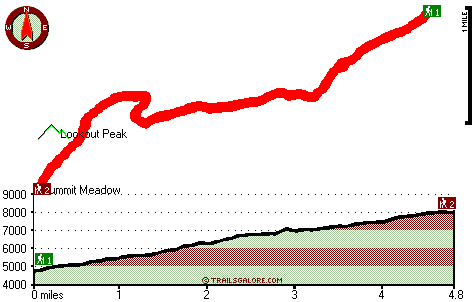
Trailhead 1 to Trailhead 2:
Total hiking length = 4.8 miles
Total climbing distance = 3.8 miles
Difficulty : Difficult
Casual Hiking Pace: 5.5 hours
Fast Hiking Pace: 3 hours

Trailhead 2 to Trailhead 1:
Total hiking length = 4.8 miles
Total climbing distance = .3 miles
Difficulty : Easy
Casual Hiking Pace: 3 hours
Fast Hiking Pace: 1.5 hours
    Trailhead 1 back to Trailhead 1:
Total hiking length = 9.6 miles
Total climbing distance = 4.1 miles
Difficulty : Difficult
Casual Hiking Pace: 8.5 hours
Fast Hiking Pace: 5.5 hours

Trailhead 2 back to Trailhead 2:
Total hiking length = 9.6 miles
Total climbing distance = 4.1 miles
Difficulty : Difficult
Casual Hiking Pace: 8.5 hours
Fast Hiking Pace: 5.5 hours

Total elevation difference: 3586 feet


Comfort Inn & Suites Sequoia Kings Canyon, Three Rivers
25 miles away
Hotel offers free high-speed Internet access, fitness room with sauna, seasonal outdoor pool/hot tub, picnic area, conference room and business center. Hot tub and fireplace in some rooms. National Pa...
  
Americas Best Value Lazy J Ranch Three Rivers, Three Rivers
26 miles away
Welcome to the Americas Best Value Inn Lazy J Ranch Three Rivers. All of our guest rooms are ground level, and there are some individual housekeeping cottages. All rooms are ground level, some with...
User input for Don Cecil Trail, Southern Sierra Nevada, Fresno County, California:

Submit Input:
Your Name:
Write or Paste Input here:

Upload picture:      Review Guidelines


Outdoors Recreation Near Visalia-Porterville, California
Very comprehensive list of a variety of outdoors recreation in the vicinity of Visalia-Porterville, California, the metro area neareast to Don Cecil Trail. Find info on campgrounds, hiking trails, ski resorts, lakes, beaches, parks, whitewater and more.

Current weather conditions at Don Cecil Trail, Southern Sierra Nevada, Fresno County, California
WXPort

Local climate location: GRANT GROVE 20 miles away

Days Inn Bishop, Bishop
37 miles away
Welcome to the Days Inn Bishop. We are a 3 Diamond Triple A approved property. Our property offers many amenities such as Complimentary High Speed Internet Access, refrigerator & Microwaves, coffee ma...

Super 8 Bishop, Bishop
37 miles away
Welcome to Super 8 Bishop, CA. The AAA approved motel is easily accessible from Hwy 395 North and South. The Super 8 has an outdoor swimming pool, guest laundry and offers a SuperStart Breakfast eve...

More Hotels and Campgrounds Near Don Cecil Trail, Southern Sierra Nevada, Fresno County, California

OTHER_INFO
  Southern Sierra Nevada Campgrounds
Complete list of all the campgrounds in the Southern Sierra Nevada.

Southern Sierra Nevada Outdoors Info
Complete outdoors info for the Southern Sierra Nevada.

California Hiking Trails
Complete list of all hiking trails in California

Books about hiking trails in California
List of books available on Amazon.com about hiking trails in California.

California Outdoors Index
This is a very comprehensive index of outdoors activities in the great state of California.


TOPO
High quality water resistant topo map of Don Cecil Trail, Southern Sierra Nevada, Fresno County, California.

OUTDOORS_GUIDE
These outdoors activities are available near Don Cecil Trail.
 Trails Near Don Cecil Trail:
Sheep Creek Trail, Fresno County , 3 miles away,  6.2 hiking miles, 1123 feet elevation difference
Pacific Crest Trail - section 11, County , 13 miles away, 264.9 hiking miles, 9028 feet elevation difference
 Camp Grounds Near Don Cecil Trail:
Sheep Creek Campground, Fresno County, 1 miles away
Sentinel Campground, Fresno County, 1 miles away
Canyon View Campground, Fresno County, 1 miles away
Moraine Campground, Fresno County, 1 miles away
Log Bridge Campground, Tulare County, 10 miles away
 Whitewater Near Don Cecil Trail:
Kings River - Middle Fork, Fresno County County , 11 miles away, Class V+ - 29 miles long (Dusy Branch to South Fork confluence)
Kaweah River - Middle Fork, Tulare County County , 18 miles away, Class V - 4.8 miles long (Hospital Rock)
Kings River, Fresno County County , 19 miles away, Class V - 10 miles long (Middle South Fork confluence to Garnet Dike Campground)
Kaweah River - North Fork, Tulare County County , 19 miles away, Class V+ - 8 miles long (Tarbell Pocket to Yucca Creek)
 National Parks Near Don Cecil Trail:
Sequoia & Kings Canyon National Park, Three Rivers - CA , 24 miles away
Devils Postpile National Monument, Mammoth Lakes - CA , 43 miles away
 Hotels Near Don Cecil Trail:
Comfort Inn & Suites Sequoia Kings Canyon, Three Rivers , 25 miles away
Americas Best Value Lazy J Ranch Three Rivers, Three Rivers , 26 miles away
Days Inn Bishop, Bishop , 37 miles away
Super 8 Bishop, Bishop , 37 miles away
Americas Best Value Inn/Bishop, Bishop , 38 miles away

Outdoors related information copyright © Stratus-Pikpuk, Inc. - Detailed hotel information copyright © Interactive Hotel Solutions