California hiking trails - Doe Ridge Trail, Klamath Mountains, Trinity County

   
  Here in California backpacking is an excellent way to spend some time. Alright, enough of spending all this time inside a building, time to get out, and Doe Ridge Trail in Trinity County, California is just the spot. California has plenty of good wilderness hiking trails, and among these are Doe Ridge Trail in Trinity County. With its 12.2 miles of walking distance; it's considered a longer backcountry trek. This trail sometimes gets very dry, so don’t forget to check for any current fire restrictions before you go. The total elevation difference for
    Doe Ridge Trail is 2,253 feet, and that is about average. Doe Ridge Trail gets a normal amount of rainfall; the month with most of the rain is January; July is when it's the driest. Now, this is roughly a 2-day hike, so better have big backpack to fit all the stuff you need. This
wilderness hiking trail is many miles long with an average amount of climbing distance which makes this backcountry hiking trail delightful for hard core backpackers looking for adventure. Different parts of this backcountry hiking trail are at very different elevations, and that means that some parts of the backcountry hiking trail could be very different from other parts of it. These wilderness hiking trails here in the Klamath Mountains are a perfect way to explore these peaks. Throughout the days of summer here at Doe Ridge Trail, high temperatures  
typically reach the 90's with night lows in the 50's. Highs during the wintertime are regularly in the 40's, and night lows at Doe Ridge Trail during the wintertime regularly plunge into the 30's. This is a one trailhead hiking and backpacking trail, so in and out is the way to backcountry hike it normally. Please follow all local rules about fires and camping. Each one of the many wilderness hiking trails of California has its own unique loveliness. Doe Ridge Trail is a very long way away from civilization, and it is a fine hiking trail. This is a long trail, so make sure you bring plenty of supplies. California is a perfect spot for backcountry trekkers. There are so many backcountry hiking trails in this vicinity.

Briefly about the general area:
Places like Haynes Delight are magnificent to go to, and why not camp at Pine Root Spring Campground if you're here at Doe Ridge Trail. There's no way anybody can get bored here in the Klamath Mountains. Camping at Doe Ridge Trail is great fun, Hammerhorn Campground is a great local campground, and Water Spout Spring is a great local attraction.
Any time is a fine time at Doe Ridge Trail if you adore the outdoors. Penney Glades is a nice spot to check out, and let's not forget Yellowjacket Creek which is a stream that you may encounter while you're here. Yep, outdoors cool stuff truly is bountiful here in the Klamath Mountains. Doe Ridge Trail is near Wrights Valley which is certainly worth stopping at, and paddling on Eel River - North Fork is so much fun. Put some time aside to spend at Waterspout while you're here at Doe Ridge Trail; don't forget to take a look at Fern Point since you're here.
At this river you will always have a good time. Whitewater paddling is good on Mad River, and there's some flowing water nearby, Schoolmarm Creek is a stream you can take a look at during your stay. This river has so much to offer.

Location of Trailhead: Latitude 40.0984, Longitude -123.1488
- - Directions and Road Map

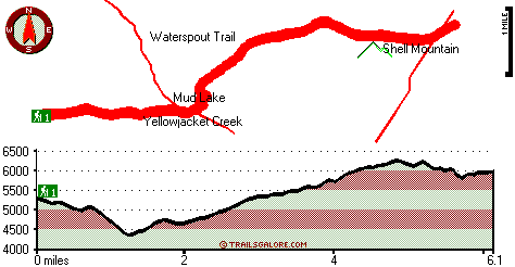
Total in and out hiking length = 12.2 miles

Total climbing distance = 5.6 miles

Difficulty : Difficult

Casual Hiking Pace: 2 days

Fast Hiking Pace: 7.5 hours

Total elevation difference: 2253 feet


Best Western Weaverville Victorian Inn, Weaverville
34 miles away
  
Beside Still Waters Farm Bed & Breakfast Cottages, Willits
40 miles away
User input for Doe Ridge Trail, Klamath Mountains, Trinity County, California:

Submit Input:
Your Name:
Write or Paste Input here:

Upload picture:      Review Guidelines


Outdoors Recreation Near Ukiah, California
Very comprehensive list of a variety of outdoors recreation in the vicinity of Ukiah, California, the metro area neareast to Doe Ridge Trail. Find info on campgrounds, hiking trails, ski resorts, lakes, beaches, parks, whitewater and more.

Current weather conditions at Doe Ridge Trail, Klamath Mountains, Trinity County, California
WXPort

Local climate location: BIG BAR RANGER STATION 18 miles away

Super 8 Motel - Willits, Willits
42 miles away
Welcome to Willits, CA, located in the heart of Mendocino County. Willits offers many activities in and around the community, and gives you firsthand experience of small town America at its finest. ...

Old West Inn Willits, Willits
42 miles away
Willits is known as the Heart of Mendocino County and the Gateway to the Redwoods. The Old West Inn, a Magnuson Hotels affiliate, is located off of Highway 101 approximately 140 miles North of San Fra...

More Hotels and Campgrounds Near Doe Ridge Trail, Klamath Mountains, Trinity County, California

OTHER_INFO
  Klamath Mountains Campgrounds
Complete list of all the campgrounds in the Klamath Mountains.

Klamath Mountains Outdoors Info
Complete outdoors info for the Klamath Mountains.

California Hiking Trails
Complete list of all hiking trails in California

Books about hiking trails in California
List of books available on Amazon.com about hiking trails in California.

California Outdoors Index
This is a very comprehensive index of outdoors activities in the great state of California.


TOPO
High quality water resistant topo map of Doe Ridge Trail, Klamath Mountains, Trinity County, California.

OUTDOORS_GUIDE
These outdoors activities are available near Doe Ridge Trail.
 Trails Near Doe Ridge Trail:
Yellowjacket Trail, Trinity County , 2 miles away,  9.6 hiking miles, 1508 feet elevation difference
Buck Ridge Trail, Trinity County , 2 miles away, 10.6 hiking miles, 3052 feet elevation difference
Waterspout Trail, Trinity County , 3 miles away, 5.6 hiking miles, 2078 feet elevation difference
Haynes Delight Trail, Trinity County , 3 miles away,  12.6 hiking miles, 1310 feet elevation difference
Wrights Valley Trail, Trinity County , 4 miles away,  9.4 hiking miles, 1472 feet elevation difference
Willow Trail, Trinity County , 5 miles away,  10 hiking miles, 1081 feet elevation difference
Morrison Trail, Trinity County , 5 miles away,  10.2 hiking miles, 875 feet elevation difference
 Camp Grounds Near Doe Ridge Trail:
Pine Root Spring Campground, Trinity County, 10 miles away
Hammerhorn Campground, Mendocino County, 11 miles away
North Fork Beegum Campground, Shasta County, 12 miles away
Little Doe Campground, Mendocino County, 14 miles away
Beegum Gorge Campground, Shasta County, 15 miles away
 Whitewater Near Doe Ridge Trail:
Mad River, Trinity County County , 12 miles away, Class III - 5.8 miles long (North and South Fork confluence to Barry Creek Road)
Eel River - North Fork, Trinity/ Mendocino County County , 15 miles away, Class IV - 12 miles long (Salt Creek to Hulls Creek)
Hayfork Creek, Trinity County County , 16 miles away, Class III - 3.5 miles long (Above Highway 36 to Highway 36)
Eel River - North Fork, Trinity/ Mendocino County County , 17 miles away, Class III - 8 miles long (Hulls Creek to Mina Road)
Beegum Creek, Shasta / Tehama County County , 17 miles away, Class IV-V(V+) - 7 miles long (USFS Campground to State Highway 36)
 National Parks Near Doe Ridge Trail:
Whiskeytown National Recreation Area, Whiskeytown - CA , 46 miles away
 Hotels Near Doe Ridge Trail:
Best Western Weaverville Victorian Inn, Weaverville , 34 miles away
Lewiston Hotel, Lewiston , 38 miles away
Beside Still Waters Farm Bed & Breakfast Cottages, Willits , 40 miles away
Super 8 Motel - Willits, Willits , 42 miles away
Old West Inn Willits, Willits , 42 miles away
 Lakes Near Doe Ridge Trail
Mud Lake, Trinity County , 2 miles away

Outdoors related information copyright © Stratus-Pikpuk, Inc. - Detailed hotel information copyright © Interactive Hotel Solutions