California hiking trails - Divide Trail, Klamath Mountains, Trinity County

   
  California has plenty of splendid backpacking and hiking trails; one of them being Divide Trail in Trinity County. Here in the splendid state of California backcountry backpacking is an outstanding way to spend some time. There are plenty of backpacking and hiking trails in California; each one of them is well worth a backcountry hike. You spend the whole trek in roughly the same elevation zone which means the conditions are about the same from start to finish. An average amount of rain falls at Divide Trail; through December this vicinity sees the most rain;
    July meanwhile is the driest month. Put on your backcountry hiking shoes, and hit the wilderness trail, Divide Trail in Trinity County, California is an outstanding selection. For the duration of the summer, highs commonly are in the 90's at Divide Trail. Throughout the moonlight
hours it's frequently in the 50's. Throughout the winter highs are in the 40's, and through the dark hours in the wintertime at Divide Trail temperatures plunge to the 30's. Don’t forget to check for any current restrictions or closures before you go. This walk should take you about 2 days, so better have big backpack to fit all the stuff you need. At parts of the year this neighborhood sees very little rain, so do check for current fire restrictions before you go if you plan to bring a stove or make a camp fire. This backcountry trail is many miles  
long having an average number of uphill miles which makes this great outdoors trail nice for hard core backpackers looking for adventure. With its 13.4 miles of walking distance; it's considered a longer trek. Divide Trail has a total elevation difference of 1,022 feet which is about average. There are not too many great outdoors trails in this vicinity. Trails like this one here in the Klamath Mountains are a really brilliant way to spend quality time in the wilderness. Divide Trail being so distant from the closest settlement, backcountry hiking it is always enjoyable. This is a long backcountry hiking trail, so don't forget to pack enough supplies. Divide Trail is a two ended backcountry hiking trail with two trailheads which means you have the option of backpacking it one way if you have someone to pick you up at the other end. This part of California has a tremendous deal of available outdoors pastimes.

Briefly about the general area:
Do schedule some time to explore Wilson Point near Divide Trail if you have a chance, and get your heart beating on the great whitewater of Hayfork Creek. Divide Trail is delightful enough to spend more than a day at, North Fork Beegum Campground is a delightful local campground.
A nice spot to camp here at Divide Trail is Pine Root Spring Campground, and why not explore nearby Wilson Creek if you're here at Divide Trail. So much exciting stuff to do in the Klamath Mountains, not enough time. Gemmill Gulch is in the vicinity of Divide Trail and is a magnificent spot, and it's a wonderful idea to stop by Hall City Creek.

Location of Trailhead 1: Latitude 40.4044, Longitude -123.082
- - Directions and Road Map

Location of Trailhead 2: Latitude 40.4754, Longitude -123.1101
- - Directions and Road Map


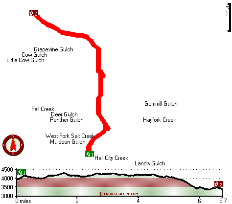
Trailhead 1 to Trailhead 2:
Total hiking length = 6.7 miles
Total climbing distance = 2.9 miles
Difficulty : Difficult
Casual Hiking Pace: 6 hours
Fast Hiking Pace: 3.5 hours

Trailhead 2 to Trailhead 1:
Total hiking length = 6.7 miles
Total climbing distance = 3.6 miles
Difficulty : Difficult
Casual Hiking Pace: 6.5 hours
Fast Hiking Pace: 3.5 hours
    Trailhead 1 back to Trailhead 1:
Total hiking length = 13.4 miles
Total climbing distance = 6.5 miles
Difficulty : Difficult
Casual Hiking Pace: 2 days
Fast Hiking Pace: 8 hours

Trailhead 2 back to Trailhead 2:
Total hiking length = 13.4 miles
Total climbing distance = 6.5 miles
Difficulty : Difficult
Casual Hiking Pace: 2 days
Fast Hiking Pace: 8 hours

Total elevation difference: 1022 feet


Redding Ca Travelodge, Redding
48 miles away
Reddings Best Kept Lodging Secret Our Mission We are committed to providing our guests with standards of excellence combined with competence, courtesy and consideration that surpass their expectatio...
  
Rodeway Inn Redding, Redding
48 miles away
Old Mining town with much outdoor recreation. Located on the north end of town. Walking distance to restaurants and park. 24-hr front desk. Guests receive a voucher for a fully cooked to order breakf...
User input for Divide Trail, Klamath Mountains, Trinity County, California:

Submit Input:
Your Name:
Write or Paste Input here:

Upload picture:      Review Guidelines


Outdoors Recreation Near Redding, California
Very comprehensive list of a variety of outdoors recreation in the vicinity of Redding, California, the metro area neareast to Divide Trail. Find info on campgrounds, hiking trails, ski resorts, lakes, beaches, parks, whitewater and more.

Current weather conditions at Divide Trail, Klamath Mountains, Trinity County, California
WXPort

Local climate location: BIG BAR RANGER STATION 5 miles away

Americas Best Inns-Redding, Redding
49 miles away
The Americas Best Inn and Suites Redding is a recent conversion to a franchise hotel. Its offers rhetoric charm with modern amenities. The hotel is centrally located in City of Redding, along the Sacr...

Howard Johnson Express, Redding
50 miles away
The Howard Johnson Express Inn - Redding is located just off I-5 in the heart of Redding, CA. A short 30 minutes from the hotel is the famous Mount Shasta and less than an hour away is Mount Lassen. ...

More Hotels and Campgrounds Near Divide Trail, Klamath Mountains, Trinity County, California

OTHER_INFO
  Klamath Mountains Campgrounds
Complete list of all the campgrounds in the Klamath Mountains.

Klamath Mountains Outdoors Info
Complete outdoors info for the Klamath Mountains.

California Hiking Trails
Complete list of all hiking trails in California

Books about hiking trails in California
List of books available on Amazon.com about hiking trails in California.

California Outdoors Index
This is a very comprehensive index of outdoors activities in the great state of California.


TOPO
High quality water resistant topo map of Divide Trail, Klamath Mountains, Trinity County, California.

OUTDOORS_GUIDE
These outdoors activities are available near Divide Trail.
 Trails Near Divide Trail:
Bluford Trail, Shasta County , 12 miles away, 3 hiking miles, 2510 feet elevation difference
Rough Gulch Trail, Trinity County , 15 miles away,  8 hiking miles, 4155 feet elevation difference
 Camp Grounds Near Divide Trail:
North Fork Beegum Campground, Shasta County, 7 miles away
Pine Root Spring Campground, Trinity County, 7 miles away
Philpot Campground, Trinity County, 8 miles away
Basin Gulch Campgrounds, Shasta County, 9 miles away
Mesa Pines Mobile Home Park, Hayfork, 10 miles away
 Whitewater Near Divide Trail:
Hayfork Creek, Trinity County County , 2 miles away, Class III - 3.5 miles long (Above Highway 36 to Highway 36)
Hayfork Creek, Trinity County County , 10 miles away, Class III-V - 12.7 miles long (Gemmil Gulch Picnic Ground to Carr Creek)
Beegum Creek, Shasta / Tehama County County , 13 miles away, Class IV-V(V+) - 7 miles long (USFS Campground to State Highway 36)
Cottonwood Creek - Middle Fork, Shasta/ Tehama County County , 17 miles away, Class IV - 11.1 miles long (Knob Gulch confluence to Platina Road)
Canyon Creek, Trinity County County , 17 miles away, Class III-IV - 8.5 miles long (Bridge 8.5 miles upstream of Junction City to Junction City)
 National Parks Near Divide Trail:
Whiskeytown National Recreation Area, Whiskeytown - CA , 36 miles away
 Hotels Near Divide Trail:
Redding Ca Travelodge, Redding , 48 miles away
Rodeway Inn Redding, Redding , 48 miles away
Americas Best Inns-Redding, Redding , 49 miles away
Howard Johnson Express, Redding , 50 miles away
VAGABOND INN REDDING, Redding , 50 miles away

Outdoors related information copyright © Stratus-Pikpuk, Inc. - Detailed hotel information copyright © Interactive Hotel Solutions