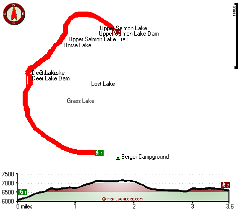
| |
|
| | There are many good backcountry trails in California, and one of those is Deer Lake Trail in Sierra County. There are numerous backcountry trails in California, and each one is wonderful in its own way. Gotta get out of the city man, and Deer Lake Trail in Sierra County, California is a really pleasant location to spend some time. Deer Lake Trail is a normal length great outdoors hiking trail having an average number of uphill miles which makes it an outstanding wilderness hiking trail for experienced trekkers in wonderful shape. This is one of many wilderness |
|
hiking trails in the surrounding region. When you're here in California backpacking along one of its backcountry trails is the good thing to do. This backpacking trail has a total elevation difference of 1,145 feet, and that is about average. With its 7.2 miles of walking distance
| | it's a mid length backcountry hike. Sometimes this great outdoors trail gets really dry, so do check for current fire restrictions before you go if you plan to bring a stove or make a camp fire. Deer Lake Trail has two trailheads which means you have the option of hiking it one way if you have someone to pick you up at the other end. This walk shouldn't take more than 6.5 hours, but of course some people walk a bit slower and some a bit faster. The amount of rainfall that falls at Deer Lake Trail is near the national average; most of the rain falls during | |
|
January while July is ordinarily the driest month. Deer Lake Trail stays roughly within the same elevation zone the whole time which means the conditions are about the same from start to finish. Hiking and backpacking trails like this one here in the Northern Sierra Nevada are
a very good way to see these hills. Don’t forget to check for any current restrictions or closures before you go. Outdoors folks generally like this part of California. It's a lengthy trip from Truckee-Grass Valley to Deer Lake Trail, but hiking is such an enjoyable thing to do,
and this is an outstanding location to do that. Keep in mind that this is a long great outdoors trail, so don't forget to pack enough supplies. Summertime highs at Deer Lake Trail ordinarily tend to be in the 90's. Summer overnight lows plunge down to the 40's. Daytime highs through
the winter are in the 40's, and through the dark hours in the winter at Deer Lake Trail temperatures plunge to the 20's.
Briefly about the general area: Church Creek is a perfect local stream, and if you came for an overnight stay Berger Campground is a glorious site
to camp. This is a great river. Take a side tour to Sawmill Creek; Lusk Meadows is a great spot here at Deer Lake Trail. Don’t forget to go to Butcher Ranch Meadows while you're here at Deer Lake Trail, and why not camp at Packsaddle Campground while you're here at Deer Lake
Trail. All the outdoors enjoyable things in the Northern Sierra Nevada will keep you coming back time and again. Get dripping wet paddling on Yuba River - North Fork; Deer Lake Dam is a site that is in close proximity to Deer Lake Trail. Just can't get enough of Deer Lake Trail.
A spree to Deer Lake Trail wouldn't be complete without taking a look at Big Springs, and a perfect location is Packer Lake Saddle. Yeah, come up here to the Northern Sierra Nevada for a perfect time. Get yourself into a kayak and hit Lavezzola Creek.
|
|
Location of Trailhead 1: Latitude 39.6291, Longitude -120.648 - - Directions and Road Map
Location of Trailhead 2: Latitude 39.6558, Longitude -120.6441 - - Directions and Road Map

Trailhead 1 to Trailhead 2: Total hiking length = 3.6 miles Total climbing distance = 1.6 miles Difficulty : Medium Casual Hiking Pace:
3 hours
Fast Hiking Pace:
2 hours
Trailhead 2 to Trailhead 1: Total hiking length = 3.6 miles Total climbing distance = 1.5 miles Difficulty : Medium Casual Hiking Pace:
3 hours
Fast Hiking Pace:
1.5 hours
| | Trailhead 1 back to Trailhead 1: Total hiking length = 7.2 miles Total climbing distance = 3.1 miles Difficulty : Difficult Casual Hiking Pace:
6.5 hours
Fast Hiking Pace:
4 hours
Trailhead 2 back to Trailhead 2: Total hiking length = 7.2 miles Total climbing distance = 3.1 miles Difficulty : Difficult Casual Hiking Pace:
6.5 hours
Fast Hiking Pace:
4 hours
|
Total elevation difference: 1145 feet

|
| |
Chalet View Lodge, Graeagle
|
11 miles away
A Luxurious, yet affordable, lodging experience awaits you at Chalet View Lodge ? a stylish getaway to the splendor of the Mohawk Valley. Immerse yourself in spacious, elegant accommodations and pers...
|
|
User input for Deer Lake Trail, Northern Sierra Nevada, Sierra County, California:

Outdoors Recreation Near Truckee-Grass Valley, California Very comprehensive list of a variety of outdoors recreation in the vicinity of Truckee-Grass Valley, California, the metro area neareast to Deer Lake Trail. Find info on campgrounds, hiking trails, ski resorts, lakes, beaches, parks, whitewater and more.
More Hotels and Campgrounds Near Deer Lake Trail, Northern Sierra Nevada, Sierra County, California
| |
| |
 |
|
| These outdoors activities are available near Deer Lake Trail. |
| | Trails Near Deer Lake Trail:
 |
Pacific Crest Trail - section 15,
County
, 2 miles away, 109.3 hiking miles, 6884 feet elevation difference |
 |
Butcher Ranch Trail, Sierra
County
, 5 miles away, 3 hiking miles, 2125 feet elevation difference |
 |
Third Divide Trail, Sierra
County
, 7 miles away, 2.5 hiking miles, 2062 feet elevation difference |
 |
Eureka Lake Trail, Plumas
County
, 8 miles away, 1.4 hiking miles, 1203 feet elevation difference |
 |
Second Divide Trail, Sierra
County
, 8 miles away, 7.2 hiking miles, 1442 feet elevation difference |
 |
Haskell Peak Trail, Sierra
County
, 11 miles away, 2.2 hiking miles, 1117 feet elevation difference |
 |
Bedbug Smith Trail, Sierra
County
, 11 miles away, 6.2 hiking miles, 1927 feet elevation difference |
|
| | Whitewater Near Deer Lake Trail:
 |
Yuba River - North Fork, Sierra County
County
, 6 miles away, Class IV-V - 13 miles long (Wild Plum Campground to Downieville) |
 |
Lavezzola Creek, Sierra County
County
, 11 miles away, Class IV(V) - 4 miles long (2nd Divide Bridge to Downieville) |
 |
Pauley Creek, Sierra County
County
, 11 miles away, Class III-IV - 4 miles long (Second Divide Turnout to Downieville) |
 |
Yuba River - North Fork, Sierra County
County
, 14 miles away, Class II-V - 4 miles long (Downieville to Goodyears Bar Bridge) |
 |
Feather River - Middle Fork, Plumas County
County
, 15 miles away, Class II-III - 6.5 miles long (Sloat to Nelson Point) |
|
| | Hotels Near Deer Lake Trail:
 |
Chalet View Lodge, Graeagle
, 8 miles away |
 |
Chalet View Lodge, Graeagle
, 11 miles away |
 |
Rainbow Lodge, Soda Springs
, 18 miles away |
 |
Shinneyboo Creek Cabin Resort, Soda Springs
, 18 miles away |
 |
Hoyfjellet Lodge, Soda Springs
, 18 miles away |
|
|
|
 |
|