| |
|
| | We all need to get out in nature once in a while, and Dawson Peak Trail in Los Angeles County, California is a good choice. Backpacking in California never gets boring. Dawson Peak Trail is located a relatively long journey from Los Angeles-Long Beach-Santa Ana, but trekking along this hiking trail is very exciting. This is a one trailhead wilderness hiking trail, so you're looking at an in and out trek. Different parts of Dawson Peak Trail are at very different elevations which of course means you need to be prepared for different conditions on different |
|
parts of the hiking trail. The warmest time of the year at Dawson Peak Trail comes with high temperatures in the 90's while night lows are commonly in the 50's. For the duration of the wintertime this spot gets highs in the 60's; night lows in the 40's for Dawson Peak Trail. This
| | is a neighborhood covered with lots of wilderness trails. There are so many glorious wilderness trails for backcountry backpacking in California; Dawson Peak Trail in Los Angeles County is one of them. Dawson Peak Trail gets a normal amount of rainfall; during the month of February you get the most rain around here; the driest month is July. Dawson Peak Trail is a very long hiking trail having an average number of uphill miles which makes this wilderness trail fine for hard core backpackers looking for adventure. California has lots of outdoors endeavors. | |
|
This wilderness hiking trail has a total elevation difference of 3,488 feet which is higher than average. The hiking trails of the San Gabriel Mountains are a brilliant way to explore these highlands. Dawson Peak Trail is quite long, so do pack enough food to last the whole trip.
Being 18 miles long; it's a long hiking trail. This neighborhood does get very dry sometimes, so don’t forget to check for any current fire restrictions before you go. Of course, this is an overnight backcountry trek, 2.5 days normally, so make sure you've got all your overnight
gear packed. Every single California wilderness trail is different from the others. And keep in mind that there could be temporary safety restrictions in place.
Briefly about the general area: People from Los Angeles-Long Beach-Santa Ana love to come to Dawson Peak Trail,
and do schedule some time to explore Buck Point if you have a chance. This river is a wonderful place to visit. Columbine Spring is an inspiring place to check out while you're here; camping is available at Manker Campground. While you're here at Dawson Peak Trail it's a good
idea to go to Manker Flat, and why not camp at Pauite Campground while you're here at Dawson Peak Trail. So much amusing stuff to do here at Dawson Peak Trail, too great to be true. Telegraph Wash flows through this area; a perfect site nearby is Dog Bone Canyon. You just can't
envision the amount of outdoors exciting stuff the San Gabriel Mountains has to offer. If you're here at Dawson Peak Trail, you could take a look at Big Butch Wash. Whohoo, so much entertaining stuff in one place! The San Gabriel Mountains is great! Don't leave Dawson Peak Trail without first paying a visit to San Antonio Falls, and a pleasant visit to Bear Flat is a tremendous way to spend an afternoon.
|
|
Location of Trailhead: Latitude 34.3287, Longitude -117.6725 - - Directions and Road Map
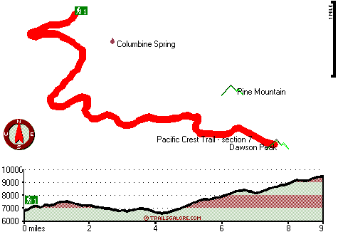
Total in and out hiking length = 18 miles
Total climbing distance = 8.3 miles
Difficulty : Difficult
Casual Hiking Pace:
2.5 days
Fast Hiking Pace:
2 days
Total elevation difference: 3488 feet

GuestHouse Inn and Stes Upland, Upland
|
11 miles away
Located in Southern California just 4.5 miles from the Ontario International Airport, situated at the base of the San Bernardino Mountains, conveniently close to Mt. Baldy and just a few minutes from ...
|
| |
Best Western Cajon Pass, Phelan
|
12 miles away
Stay at this Phelan hotel located at the base of the scenic San Bernardino Mountains and enjoy a peaceful, serene visit in California. The Best Western Cajon Pass is conveniently located at the jun...
|
|
User input for Dawson Peak Trail, San Gabriel Mountains, Los Angeles County, California:

Outdoors Recreation Near Los Angeles-Long Beach-Santa Ana, California Very comprehensive list of a variety of outdoors recreation in the vicinity of Los Angeles-Long Beach-Santa Ana, California, the metro area neareast to Dawson Peak Trail. Find info on campgrounds, hiking trails, ski resorts, lakes, beaches, parks, whitewater and more.
More Hotels and Campgrounds Near Dawson Peak Trail, San Gabriel Mountains, Los Angeles County, California
| |
| |
 |
|
| These outdoors activities are available near Dawson Peak Trail. |
| | Trails Near Dawson Peak Trail:
 |
Pacific Crest Trail - section 7,
County
, 1 miles away, 52.1 hiking miles, 7647 feet elevation difference |
 |
Baldy Trail, Los Angeles
County
, 2 miles away, 7.5 hiking miles, 7055 feet elevation difference |
 |
Ontario Peak Trail, San Bernardino
County
, 5 miles away, 5 hiking miles, 1159 feet elevation difference |
 |
Allison Trail, Los Angeles
County
, 6 miles away, 17 hiking miles, 5495 feet elevation difference |
 |
Heaton Flat Trail, Los Angeles
County
, 7 miles away, 13.3 hiking miles, 3275 feet elevation difference |
 |
Fern Canyon Trail, Los Angeles
County
, 7 miles away, 13 hiking miles, 455 feet elevation difference |
 |
West Fork Trail, San Bernardino
County
, 7 miles away, 3.2 hiking miles, 927 feet elevation difference |
|
| | Hotels Near Dawson Peak Trail:
 |
GuestHouse Inn and Stes Upland, Upland
, 11 miles away |
 |
Best Western Cajon Pass, Phelan
, 12 miles away |
 |
Super 8 Motel - Upland, Upland
, 12 miles away |
 |
Best Western Heritage Inn, Rancho Cucamonga
, 13 miles away |
 |
Hyatt Place Ontario Mills, Ontario
, 13 miles away |
|
|
|
 |
|