California hiking trails - Crags Trail, Shasta County

   
  Spending too much time indoors got you down? No problem, Crags Trail in Shasta County, California is a good place to go. A visit to California is not complete without some backcountry trekking. A lengthy drive divides Redding from Crags Trail, but it is a really brilliant wilderness hiking trail. This walk shouldn't take more than 4 hours, but you never know stuff could go wrong and you could get stuck so be prepared for that. Crags Trail is a one trailhead backcountry trail, so in and out is the way to backcountry walk it normally. There are not too many
    hiking trails in this region. Great outdoors hiking trails for backpacking, and backpacking can be found all over California; one of these is Crags Trail in Shasta County. When you're here in California backpacking along one of its backpacking trails is so much fun. Being 4.6 miles
long it's a mid length walk. For the duration of the summer months, highs ordinarily are in the 80's at Crags Trail with night lows in the 40's. The cold days of the wintertime come with highs in the 40's; after the sun is down throughout the wintertime temperatures at Crags Trail fall into the 20's. Crags Trail has a total elevation difference of 2,068 feet, and that is about average. This neighborhood does get very dry sometimes, so do check for current fire restrictions before you go if you plan to bring a stove or make a camp fire. Each one of the many  
backpacking trails of California has its own character. This trail is not that long but it's always great to bring some emergency supplies, you never know what could happen. This backpacking trail goes through some very different elevations which of course means you need to be prepared for different conditions on different parts of the backpacking trail. Crags Trail is a mid-length wilderness hiking trail with an average amount of climbing distance which makes this hiking trail great for the average trekker looking for an exciting adventure. Crags Trail gets a normal amount of rainfall; throughout January this region sees the most rain; July is when it's the driest. And keep in mind that there could be temporary safety restrictions in location.

Briefly about the general area:
Crags Trail really is in the middle of a pretty outdoors paradise. Indian Creek is a splendid local stream. Camping is available at Castle Crags State Park; nearby you stumble on pleasant places like Winton Canyon.
Soda Springs is a charming spot to explore while you're at Crags Trail, and there are plenty of people from Redding here. Take a side journey to Castle Creek, and Indian Springs is a splendid local attraction. If you came for an overnight stay Railroad Park Resort is a great site to camp, and get yourself into a kayak and hit Sacramento River.

Location of Trailhead: Latitude 41.1595, Longitude -122.3061
- - Directions and Road Map

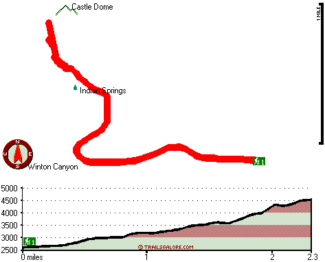
Total in and out hiking length = 4.6 miles

Total climbing distance = 1.8 miles

Difficulty : Medium

Casual Hiking Pace: 4 hours

Fast Hiking Pace: 2.5 hours

Total elevation difference: 2068 feet


Dunsmuir Travelodge, Dunsmuir
4 miles away
Located in the unbelievable scenery of Northern California, the Dunsmuir Travelodge is the ideal location to enjoy the splendors of the area. Conveniently located off Interstate 5, the Dunsmuir Travel...
  
Shastas Best Choice Inn, Dunsmuir
5 miles away
Shasta*s Best Choice Inn- come enjoy a peaceful cozy stay with breathtaking views of nature from your room. Experience the majestic view of Mt Shasta and the Siskiyou Mountains from our large picnic a...
User input for Crags Trail, Shasta County, California:

Submit Input:
Your Name:
Write or Paste Input here:

Upload picture:      Review Guidelines


Outdoors Recreation Near Redding, California
Very comprehensive list of a variety of outdoors recreation in the vicinity of Redding, California, the metro area neareast to Crags Trail. Find info on campgrounds, hiking trails, ski resorts, lakes, beaches, parks, whitewater and more.

Current weather conditions at Crags Trail, Shasta County, California
WXPort

Local climate location: WEED FIRE DEPARTMENT 8 miles away

Oak Tree Inn Dunsmuir, Dunsmuir
5 miles away
With extra-quiet guest rooms and light-proof draperies, the Oak Tree Inn opened in January 2007 in Dunsmuir, home of the best water on Earth. This 100-percent non-smoking hotel is conveniently located...

Dunsmuir Inn & Suites, Dunsmuir
5 miles away
Dunsmuir Inn & Suites is a clean, comfortable and modern motel in the heart of the Shasta Cascades. Each cozy room comes with cable television (including HBO), coffee-maker, hair-dryer, telphone, ref...

More Hotels and Campgrounds Near Crags Trail, Shasta County, California

OTHER_INFO
  California Hiking Trails
Complete list of all hiking trails in California

Books about hiking trails in California
List of books available on Amazon.com about hiking trails in California.

California Outdoors Index
This is a very comprehensive index of outdoors activities in the great state of California.


TOPO
High quality water resistant topo map of Crags Trail, Shasta County, California.

OUTDOORS_GUIDE
These outdoors activities are available near Crags Trail.
 Trails Near Crags Trail:
Castle Lake Trail, Siskiyou County , 4 miles away, 4.6 hiking miles, 588 feet elevation difference
Echo Lake Trail, Shasta County , 10 miles away, 1.2 hiking miles, 357 feet elevation difference
Sisson Calahan National Recreation Trail, Siskiyou County , 12 miles away, 9.1 hiking miles, 4437 feet elevation difference
 Camp Grounds Near Crags Trail:
Castle Crags State Park, Shasta, 1 miles away
Railroad Park Resort, Dunsmuir, 2 miles away
Rustic Trailer Park, Dunsmuir, 2 miles away
Cave Springs-motel-resort, Dunsmuir, 5 miles away
Best In The West Resort, Castella, 6 miles away
 Whitewater Near Crags Trail:
Sacramento River, Siskiyou/ Shasta County County , 2 miles away, Class III-IV - 5 miles long (Dunsmuir to Castle Craig)
Sacramento River, Siskiyou/ Shasta County County , 3 miles away, Class IV - 9 miles long (Castle Craig to Sims Road)
Sacramento River, Siskiyou/ Shasta County County , 5 miles away, Class III-IV - 7.5 miles long (Box Canyon Dam to Dunsmuir)
Sacramento River, Siskiyou/ Shasta County County , 10 miles away, Class IV - 13 miles long (Sims Flat Campground to Lake Shasta)
 National Parks Near Crags Trail:
Whiskeytown National Recreation Area, Whiskeytown - CA , 30 miles away
Lassen Volcanic National Park, Mineral - CA , 67 miles away
 Hotels Near Crags Trail:
Dunsmuir Travelodge, Dunsmuir , 4 miles away
Shastas Best Choice Inn, Dunsmuir , 5 miles away
Oak Tree Inn Dunsmuir, Dunsmuir , 5 miles away
Dunsmuir Inn & Suites, Dunsmuir , 5 miles away
Strawberry Valley Inn, Mount Shasta , 7 miles away

Outdoors related information copyright © Stratus-Pikpuk, Inc. - Detailed hotel information copyright © Interactive Hotel Solutions