| |
|
| | Every single California hiking and backpacking trail is striking in its own way. Can’t wait to get out in the fresh air, Corral Valley Trail in Alpine County, California is an excellent spot for getting out. Going for a backcountry hike here in California is a splendid way to spend some time. This is a one trailhead hiking and backpacking trail, so you're looking at an in and out backcountry trek. As long as you like the outdoors you will like California. Sometimes this great outdoors hiking trail gets really dry, so do check for current fire restrictions |
|
before you go if you plan to bring a stove or make a camp fire. With its 7.4 miles of walking distance it's an average length hiking and backpacking trail. You should count on this backcountry walk taking about 6.5 hours, but of course some people walk a bit slower and some a bit
| | faster. Now this great outdoors hiking trail is pretty long, so do pack enough food to last the whole trip. The hiking and backpacking trail stays roughly within the same elevation zone the whole time, so you get pretty much the same conditions along the whole hiking and backpacking trail. Corral Valley Trail is pretty arid regularly; January is when you get the most rain here, and July is when it's the driest. These wilderness hiking trails here in the Northern Sierra Nevada are a very glorious way to see these peaks. Please follow all local rules about fires | |
|
and camping. At Corral Valley Trail throughout the summertime months highs are in the 80's, and during the night it cools down to the 50's. For the duration of the winter highs are in the 40's, and overnight lows in the 20's for Corral Valley Trail. There are so many great outdoors
hiking trails in this vicinity. Corral Valley Trail is a mid-length wilderness hiking trail having an average number of uphill miles which makes this a very tough great outdoors hiking trail for advanced backcountry walkers looking for a great challenge. The total elevation difference
for this hiking and backpacking trail is 756 feet which is a lower than average number. Glorious hiking and backpacking trails in California are in abundance, and among these are Corral Valley Trail in Alpine County. Pretty far from Gardnerville Ranchos you find Corral Valley Trail,
but it sure is a an excellent backpacking trail.
Briefly about the general area: Yeah, come up here to the Northern Sierra Nevada for a great time. Don't leave Corral Valley Trail without first paying a visit to Llewellyn Falls; if you don’t have a problem getting wet,
you can always go whitewater paddling on West Walker River. Some close by water includes Corral Valley Creek, and if you would like a little side tour, try Coyote Valley. Corral Valley is a nice place, and getting to Tamarack Creek from Corral Valley Trail is painless. A spree
to Poison Flat rejuvenates the spirit, and camping at Leavitt Meadows Campground is always a magnificent experience. You completely ought to like Corral Valley Trail. Camping is available at Topaz Lake RV Park.
|
|
Location of Trailhead: Latitude 38.5154, Longitude -119.5577 - - Directions and Road Map
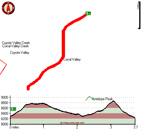
Total in and out hiking length = 7.4 miles
Total climbing distance = 3.4 miles
Difficulty : Difficult
Casual Hiking Pace:
6.5 hours
Fast Hiking Pace:
4.5 hours
Total elevation difference: 756 feet

Super 8 Gardnerville/Carson City, Gardnerville
|
12 miles away
Located on Topaz Lake, fishing, hiking, watersports, camping Sweetwater Mtn views Downtown Gardnerville - 20 mi Mommoth Lakes - 90 mi Reno - 70 mi Lake Tahoe - 40 mi Yosemite Nat'l Park - 150 mi Topaz...
|
| |
Best Western Topaz Lake Inn, Topaz Lake
|
12 miles away
The Best Western Topaz Lake Inn features modern accommodations and a spectacular view of Topaz Lake and the surrounding mountains, from every room. Located on the eastern slope of the Sierra's at the...
|
|
User input for Corral Valley Trail, Northern Sierra Nevada, Alpine County, California:

Outdoors Recreation Near Gardnerville Ranchos, Nevada Very comprehensive list of a variety of outdoors recreation in the vicinity of Gardnerville Ranchos, Nevada, the metro area neareast to Corral Valley Trail. Find info on campgrounds, hiking trails, ski resorts, lakes, beaches, parks, whitewater and more.
More Hotels and Campgrounds Near Corral Valley Trail, Northern Sierra Nevada, Alpine County, California
| |
| |
 |
|
| These outdoors activities are available near Corral Valley Trail. |
| | Trails Near Corral Valley Trail:
 |
Silver King Trail, Alpine
County
, 1 miles away, 23.6 hiking miles, 1976 feet elevation difference |
 |
Early Emigrant and Indian Trail, Mono
County
, 6 miles away, 7.6 hiking miles, 2323 feet elevation difference |
 |
Lost Canyon Trail, Mono
County
, 7 miles away, 9.9 hiking miles, 3648 feet elevation difference |
 |
Pacific Crest Trail - section 13,
County
, 14 miles away, 66 hiking miles, 3818 feet elevation difference |
|
| | Whitewater Near Corral Valley Trail:
 |
West Walker River, Mono County
County
, 9 miles away, Class IV-V - 2.3 miles long (Leavitt Station Trailhead to Pickel Meadow) |
 |
West Walker River, Mono County
County
, 10 miles away, Class III-V - 11 miles long (Highway 395 Bridge to Walker) |
 |
Carson River - East Fork, Alpine County
County
, 14 miles away, Class III - 7.3 miles long (Cave Rock to Hangman's Bridge) |
|
| | Hotels Near Corral Valley Trail:
 |
Super 8 Gardnerville/Carson City, Gardnerville
, 12 miles away |
 |
Best Western Topaz Lake Inn, Topaz Lake
, 12 miles away |
 |
David Walley's Resort, Genoa
, 26 miles away |
 |
Carson Valley Inn, Minden
, 28 miles away |
 |
Holiday Inn Express Hotel & Suites MINDEN, Minden
, 28 miles away |
|
|
|
 |
|