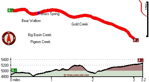
California hiking trails - Cone Point Trail, Southern Cascade Range, Shasta County

   
  Cone Point Trail is a hiking trail pretty far from Redding, but trekking along this hiking trail is very fun. Hiking here in California is a good way to spend some time. Every backpacking and hiking trail in California is worth trekking. This is a wilderness hiking trail that is quite long, so do pack enough food to last the whole trip. The total elevation difference for Cone Point Trail is 633 feet, and that is lower than average. Great outdoors trails are good and plentiful in California, and one of these is Cone Point Trail in Shasta County. The
    length of this wilderness trail is about average with an average amount of climbing distance which makes this a very tough trail for advanced walkers looking for a brilliant challenge. Cone Point Trail has two trailheads, so backcountry backpacking it one way is an option if you
can arrange for a ride back. Don’t forget to check for any current restrictions or closures before you go. With its 6.4 miles of walking distance it's an average length trail. You spend the whole trek in roughly the same elevation zone which means the conditions are about the same from start to finish. This part of California has a good deal of available outdoors pursuits. Finally, trekking time is here again, and Cone Point Trail in Shasta County, California is a really splendid place to spend some time. Sometimes this wilderness hiking trail gets really  
dry, so do check for current fire restrictions before you go if you plan to bring a stove or make a camp fire. The wilderness trails of the Southern Cascade Range are a really tremendous way to spend quality time in nature. Cone Point Trail is a rather wet place ordinarily with a good deal of rainfall; through the month of January you get the most rain around here, and July on the other hand is the driest. Throughout the warm months, highs commonly are in the 80's at Cone Point Trail. During the moonlight hours it's ordinarily in the 40's. The winter comes with highs in the 40's with temperatures at Cone Point Trail dipping down into the 20's all through winter nights. There are so many trails in this neighborhood. You should count on this backcountry hike taking about 6 hours, but you never know stuff could go wrong and you could get stuck so be prepared for that.

Briefly about the general area:
But wait, there's more fun stuff to do in the Southern Cascade Range. Bear Wallow is a stunning site any time of year, and some of the water nearby flows, like Gold Creek. Not enough hours in a day to enjoy the Southern Cascade Range. Pit River has a nice whitewater paddling spot close by.
A short tour to Grass Spring is always worthwhile, and you can stay the night at Fowlers Campground. A visit to Cone Point Trail wouldn't be complete without taking a look at Dad Lofton Spring, and Steep Hollow is another perfect place to take a look at nearby. So much amusing stuff close to Cone Point Trail, definitely extraordinary. Places like Angel Meadow are brilliant to visit. You'll need more than a day to explore everything Cone Point Trail has to offer, you can camp at Deadlun Campground.
If you don't mind getting covered with water, you can always go whitewater paddling on McCloud River, and swing by Big Basin Creek it's a tremendous location to go to.

Location of Trailhead 1: Latitude 41.1788, Longitude -121.998
- - Directions and Road Map

Location of Trailhead 2: Latitude 41.1664, Longitude -121.9462
- - Directions and Road Map


Trailhead 1 to Trailhead 2:
Total hiking length = 3.2 miles
Total climbing distance = 2 miles
Difficulty : Medium
Casual Hiking Pace: 3 hours
Fast Hiking Pace: 2 hours

Trailhead 2 to Trailhead 1:
Total hiking length = 3.2 miles
Total climbing distance = .9 miles
Difficulty : Easy
Casual Hiking Pace: 2.5 hours
Fast Hiking Pace: 1.5 hours
    Trailhead 1 back to Trailhead 1:
Total hiking length = 6.4 miles
Total climbing distance = 2.9 miles
Difficulty : Difficult
Casual Hiking Pace: 6 hours
Fast Hiking Pace: 4 hours

Trailhead 2 back to Trailhead 2:
Total hiking length = 6.4 miles
Total climbing distance = 2.9 miles
Difficulty : Difficult
Casual Hiking Pace: 6 hours
Fast Hiking Pace: 4 hours

Total elevation difference: 633 feet


Dunsmuir Inn & Suites, Dunsmuir
21 miles away
Dunsmuir Inn & Suites is a clean, comfortable and modern motel in the heart of the Shasta Cascades. Each cozy room comes with cable television (including HBO), coffee-maker, hair-dryer, telphone, ref...
  
Dunsmuir Travelodge, Dunsmuir
21 miles away
Located in the unbelievable scenery of Northern California, the Dunsmuir Travelodge is the ideal location to enjoy the splendors of the area. Conveniently located off Interstate 5, the Dunsmuir Travel...
User input for Cone Point Trail, Southern Cascade Range, Shasta County, California:

Submit Input:
Your Name:
Write or Paste Input here:

Upload picture:      Review Guidelines


Outdoors Recreation Near Redding, California
Very comprehensive list of a variety of outdoors recreation in the vicinity of Redding, California, the metro area neareast to Cone Point Trail. Find info on campgrounds, hiking trails, ski resorts, lakes, beaches, parks, whitewater and more.

Current weather conditions at Cone Point Trail, Southern Cascade Range, Shasta County, California
WXPort

Local climate location: MC CLOUD 7 miles away

Shastas Best Choice Inn, Dunsmuir
21 miles away
Shasta*s Best Choice Inn- come enjoy a peaceful cozy stay with breathtaking views of nature from your room. Experience the majestic view of Mt Shasta and the Siskiyou Mountains from our large picnic a...

Oak Tree Inn Dunsmuir, Dunsmuir
21 miles away
With extra-quiet guest rooms and light-proof draperies, the new Oak Tree Inn opened in January 2007 in Dunsmuir -- Home of the Best Water on Earth. This 100-percent non-smoking hotel is conveniently ...

More Hotels and Campgrounds Near Cone Point Trail, Southern Cascade Range, Shasta County, California

OTHER_INFO
  Southern Cascade Range Campgrounds
Complete list of all the campgrounds in the Southern Cascade Range.

Southern Cascade Range Outdoors Info
Complete outdoors info for the Southern Cascade Range.

California Hiking Trails
Complete list of all hiking trails in California

Books about hiking trails in California
List of books available on Amazon.com about hiking trails in California.

California Outdoors Index
This is a very comprehensive index of outdoors activities in the great state of California.


TOPO
High quality water resistant topo map of Cone Point Trail, Southern Cascade Range, Shasta County, California.

OUTDOORS_GUIDE
These outdoors activities are available near Cone Point Trail.
 Trails Near Cone Point Trail:
Angel Meadow Trail, Siskiyou County , 2 miles away, 3.1 hiking miles, 1415 feet elevation difference
Nelson Flat Trail, Shasta County , 7 miles away,  4.6 hiking miles, 697 feet elevation difference
Rough and Ready Trail, Shasta County , 8 miles away, 1.9 hiking miles, 343 feet elevation difference
Coal Mine Trail, Shasta County , 9 miles away,  10.6 hiking miles, 3603 feet elevation difference
Pacific Crest Trail - section 17, County , 11 miles away, 85.8 hiking miles, 5083 feet elevation difference
 Camp Grounds Near Cone Point Trail:
Fowlers Campground, Siskiyou County, 5 miles away
Deadlun Campground, Shasta County, 6 miles away
Hawkins Landing Campground, Shasta County, 6 miles away
Ah-Di-Na Campground, Shasta County, 9 miles away
Mc Cloud Dance Country RV Park, Mccloud, 11 miles away
 Whitewater Near Cone Point Trail:
McCloud River, Siskiyou County County , 4 miles away, Class III-IV - 10 miles long (Fowler Campground to McCloud Reservoir)
Pit River, Shasta County County , 10 miles away, Class IV - 9 miles long (Pit 5 Dam to Pit 5 Powerhouse)
Pit River, Shasta County County , 15 miles away, Class IV - 7 miles long (Pit 4 Dam to Pit 4 Powerhouse)
McCloud River, Shasta County County , 16 miles away, Class III-IV - 24 miles long (McCloud Reservoir to Lake Shasta)
 National Parks Near Cone Point Trail:
Whiskeytown National Recreation Area, Whiskeytown - CA , 50 miles away
Lassen Volcanic National Park, Mineral - CA , 51 miles away
Lava Beds National Monument, Tulelake - CA , 53 miles away
 Hotels Near Cone Point Trail:
Dunsmuir Inn & Suites, Dunsmuir , 21 miles away
Dunsmuir Travelodge, Dunsmuir , 21 miles away
Shastas Best Choice Inn, Dunsmuir , 21 miles away
Oak Tree Inn Dunsmuir, Dunsmuir , 21 miles away
A-1 Choice Inn, Mount Shasta , 24 miles away

Outdoors related information copyright © Stratus-Pikpuk, Inc. - Detailed hotel information copyright © Interactive Hotel Solutions