California hiking trails - Cold Spring Trail, Sierra Madre, Santa Barbara County

   
  If you happen to be in California, why not go backpacking, it is so much fun. There are wilderness hiking trails all over California; Cold Spring Trail is one of them, and it's in Santa Barbara County. Gotta get out of the urban center man, and Cold Spring Trail in Santa Barbara County, California is a nice selection. Cold Spring Trail gets very little rainfall; the wettest month of the year is typically February, that's the one that rains the most, and the driest of the months is July. This area does get very dry sometimes, so don’t forget to check for
    any current fire restrictions before you go. Of course, this is an overnight hike, 2 days normally, so better have big backpack to fit all the stuff you need. There are plenty of wilderness hiking trails in California; each one of them is well worth a walk. It's a long trip from
Santa Barbara-Santa Maria-Goleta to Cold Spring Trail, but it sure is a a nice hiking trail. Being 14.4 miles long; it's considered a longer hike. The total elevation difference for Cold Spring Trail is 2,741 feet which is higher than average. This backcountry hiking trail is many miles long with an average amount of climbing distance which makes this a very tough hiking trail for advanced backcountry trekkers looking for a glorious challenge. Hiking here in the Sierra Madre is a very great way to see these summits. Hiking here in California is a must. Some  
parts of this hiking trail are much higher up than other parts of the hiking trail, so keep in mind that you may need to dress differently at different elevations. Summertime highs at Cold Spring Trail ordinarily tend to be in the 90's; the nighttime is a tad chillier of course, frequently in the 50's. High temperatures through the wintertime are normally in the 60's; nighttime lows at Cold Spring Trail through the wintertime frequently descend into the 30's. Now this backcountry trail is pretty long, so do pack enough food to last the whole trip. Please follow all local rules about fires and camping. This is a neighborhood covered with lots of hiking trails. This is a one trailhead trail, so you'll be hiking it in and back out.

Briefly about the general area:
Cold Springs Creek flows through this region, and Flores Flat is right here at Cold Spring Trail. Whohoo, so much amusing stuff in one place! The Sierra Madre is great! Cold Spring Trail is wonderful enough to spend more than a day at, Forbush Campground is a wonderful local campground; everyone loves Forbush Flat.
Little Caliente Spring is an inspiring location to stop by during your stay, and you must have a look at Edgecliff Point when you're here. Whohoo, so many cool things in one place! Cold Spring Trail is excellent! A spree to Cold Spring Trail wouldn't be complete without taking a look at Hot Springs, and a glorious place is Cold Spring Saddle. East Beach is a beach next to Cold Spring Trail that you can stop by; camping at Cottam Campground is always a splendid experience.
You just can't envision the amount of outdoors fun stuff the Sierra Madre has to offer. There's some flowing water close by, Hot Springs Creek is a stream you can pop by during your stay, and a glorious beach nearby is West Beach. While you're here at Cold Spring Trail you will meet lots of people from close by Santa Barbara-Santa Maria-Goleta.

Location of Trailhead: Latitude 34.4562, Longitude -119.653
- - Directions and Road Map

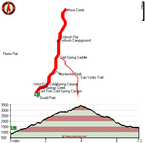
Total in and out hiking length = 14.4 miles

Total climbing distance = 6.2 miles

Difficulty : Difficult

Casual Hiking Pace: 2 days

Fast Hiking Pace: 8.5 hours

Total elevation difference: 2741 feet


Montecito Inn, Santa Barbara
3 miles away
The Montecito Inn was built in 1928 by screen legend Charlie Chaplin as an escape to paradise for his closest friends. Enriched with influences reminiscent of early Santa Barbara, newly designed guest...
  
Coast Village Inn, Santa Barbara
3 miles away
The Coast Village Inn is located in Santa Barbera, CA, nestled between the mountains and the sea in the heart of the lush coastal community of Montecito. Pristine beaches, unique shops and boutiques, ...
User input for Cold Spring Trail, Sierra Madre, Santa Barbara County, California:

Submit Input:
Your Name:
Write or Paste Input here:

Upload picture:      Review Guidelines


Outdoors Recreation Near Santa Barbara-Santa Maria-Goleta, California
Very comprehensive list of a variety of outdoors recreation in the vicinity of Santa Barbara-Santa Maria-Goleta, California, the metro area neareast to Cold Spring Trail. Find info on campgrounds, hiking trails, ski resorts, lakes, beaches, parks, whitewater and more.

Current weather conditions at Cold Spring Trail, Sierra Madre, Santa Barbara County, California
WXPort

Local climate location: CACHUMA LAKE 7 miles away

Hotel Mar Monte, Santa Barbara
4 miles away
Discover one of the finest hotels in Santa Barbara at the Hotel Mar Monte. Built in 1931, this historic coastal hotel welcomes guests with its casual elegance and first-rate service. Nestled between...

Parkside Inn, Santa Barbara
4 miles away
The Parkside Inn is owned and operated by the management of the Hotel Mar Monte. Guests may use facilities at the Hotel Mar Monte; outdoor heated pool and Jacuzzi, fitness center, Bistro Eleven Eleve...

More Hotels and Campgrounds Near Cold Spring Trail, Sierra Madre, Santa Barbara County, California

OTHER_INFO
  Sierra Madre Campgrounds
Complete list of all the campgrounds in the Sierra Madre.

Sierra Madre Outdoors Info
Complete outdoors info for the Sierra Madre.

California Hiking Trails
Complete list of all hiking trails in California

Books about hiking trails in California
List of books available on Amazon.com about hiking trails in California.

California Outdoors Index
This is a very comprehensive index of outdoors activities in the great state of California.


TOPO
High quality water resistant topo map of Cold Spring Trail, Sierra Madre, Santa Barbara County, California.

OUTDOORS_GUIDE
These outdoors activities are available near Cold Spring Trail.
 Trails Near Cold Spring Trail:
San Ysidro Trail, Santa Barbara County , 1 miles away, 3.4 hiking miles, 3463 feet elevation difference
Romero Trail, Santa Barbara County , 3 miles away,  .8 hiking miles, 579 feet elevation difference
Blue Canyon Trail, Santa Barbara County , 4 miles away, 4.7 hiking miles, 741 feet elevation difference
Tunnel Trail, Santa Barbara County , 4 miles away,  3 hiking miles, 1150 feet elevation difference
Pie Canyon Trail, Santa Barbara County , 5 miles away, 3.6 hiking miles, 1780 feet elevation difference
Jesusita Trail, Santa Barbara County , 6 miles away,  2 hiking miles, 886 feet elevation difference
Arroyo Burro Trail, Santa Barbara County , 7 miles away,  6.2 hiking miles, 2215 feet elevation difference
 Camp Grounds Near Cold Spring Trail:
Forbush Campground, Santa Barbara County, 1 miles away
Cottam Campground, Santa Barbara County, 2 miles away
Blue Canyon Campground, Santa Barbara County, 3 miles away
Mono Campground, Santa Barbara County, 3 miles away
P-Bar Flats Campground, Santa Barbara County, 4 miles away
 Beaches Near Cold Spring Trail:
East Beach, Santa Barbara County , 4 miles away
West Beach, Santa Barbara County , 5 miles away
Leadbetter Beach, Santa Barbara County , 6 miles away
 National Parks Near Cold Spring Trail:
Channel Islands National Park, Ventura - CA , 26 miles away
Santa Monica Mountains National Recreation Area, Thousand Oaks - CA , 55 miles away
 Hotels Near Cold Spring Trail:
Montecito Inn, Santa Barbara , 3 miles away
Coast Village Inn, Santa Barbara , 3 miles away
Hotel Mar Monte, Santa Barbara , 4 miles away
Parkside Inn, Santa Barbara , 4 miles away
The Inn at East Beach, Santa Barbara , 4 miles away
 Lakes Near Cold Spring Trail
Sheffield Reservoir, Santa Barbara County , 4 miles away
Gibraltar Reservoir, Santa Barbara County , 4 miles away

Outdoors related information copyright © Stratus-Pikpuk, Inc. - Detailed hotel information copyright © Interactive Hotel Solutions