| |
|
| | Backpacking here in California is a wonderful way to spend some time. Backcountry hiking trails are splendid and plentiful in California, and one of these is Coal Mine Trail in Shasta County. Every trail in California is different from the others. This is a long backcountry trail, so don't forget to pack enough supplies. Coal Mine Trail is a one trailhead wilderness trail, so in and out is the way to walk it normally. Rather far from Redding you come across Coal Mine Trail, but It's always fun to backcountry hike here. If you are in California during backcountry |
|
backpacking season you have to go backcountry backpacking. This hike should take you about 1.5 days, so make sure you've got all your overnight gear packed. Different parts of this backpacking and hiking trail are at very different elevations, and that means that some parts of
| | the backpacking and hiking trail could be very different from other parts of it. This is one of many great outdoors hiking trails in the surrounding region. At parts of the year this region sees very little rain, so don’t forget to check for any current fire restrictions before you go. The charming backpacking trails of the Southern Cascade Range are a magnificent way to explore these hills. Through the days of summer at Coal Mine Trail temperatures are commonly in the 80's while overnight lows are mostly in the 40's. All through the winter highs are | |
|
in the 40's; after the sun is down during the wintertime temperatures at Coal Mine Trail sink into the 20's. Coal Mine Trail mostly gets a great deal of rainfall; the month with most of the rain is January, and July is when it's the driest. Hitting the backpacking trails is always
a cool thing to do, and Coal Mine Trail in Shasta County, California is nature at its best. Don’t forget to check for any current restrictions or closures before you go. This backpacking trail is a very long backpacking trail with an average amount of climbing distance which makes
this great outdoors hiking trail magnificent for hard core backpackers looking for adventure. The total elevation difference for this wilderness trail is 3,603 feet which is a higher than average number. Coal Mine Trail is 10.6 miles long; it's considered a longer backcountry hike.
Briefly
about the general area: Now, you may think that's lots but there's even more amusing things to do here in the Southern Cascade Range. Don't forget to take a wonderful little tour to Coal Creek, and you can run the rapids of Pit River. Grasshopper Flat is a wonderful place
to stretch your legs a bit; a good place to stop at close by is Bull Canyon. Why not take a look at nearby Indian Creek if you're here at Coal Mine Trail, and Coal Mine Trail is a wonderful site to visit for more than one day, Deep Creek Campground is a wonderful site to camp nearby.
And if that's not enough there's a heap more enjoyable stuff to do in the Southern Cascade Range. A pleasant journey to Big Flat is a good way to spend an afternoon, and Deer Springs is always fun to check out. And if that's not enough, there's a heap more to do near Coal Mine Trail. Pit River is a good whitewater spot next to Coal Mine Trail, and you can stay the night at Deadlun Campground.
|
|
Location of Trailhead: Latitude 41.1754, Longitude -121.8475 - - Directions and Road Map
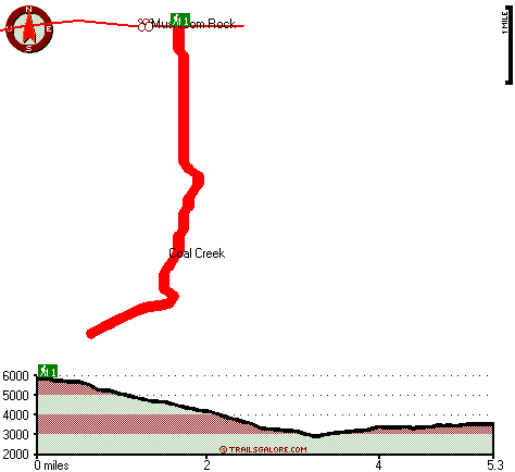
Total in and out hiking length = 10.6 miles
Total climbing distance = 4.6 miles
Difficulty : Difficult
Casual Hiking Pace:
1.5 days
Fast Hiking Pace:
6 hours
Total elevation difference: 3603 feet

Dunsmuir Inn & Suites, Dunsmuir
|
30 miles away
Dunsmuir Inn & Suites is a clean, comfortable and modern motel in the heart of the Shasta Cascades. Each cozy room comes with cable television (including HBO), coffee-maker, hair-dryer, telphone, ref...
|
| |
Dunsmuir Travelodge, Dunsmuir
|
30 miles away
Located in the unbelievable scenery of Northern California, the Dunsmuir Travelodge is the ideal location to enjoy the splendors of the area. Conveniently located off Interstate 5, the Dunsmuir Travel...
|
|
User input for Coal Mine Trail, Southern Cascade Range, Shasta County, California:

Outdoors Recreation Near Redding, California Very comprehensive list of a variety of outdoors recreation in the vicinity of Redding, California, the metro area neareast to Coal Mine Trail. Find info on campgrounds, hiking trails, ski resorts, lakes, beaches, parks, whitewater and more.
More Hotels and Campgrounds Near Coal Mine Trail, Southern Cascade Range, Shasta County, California
| |
| |
 |
|
| These outdoors activities are available near Coal Mine Trail. |
| | Trails Near Coal Mine Trail:
 |
Rough and Ready Trail, Shasta
County
, 2 miles away, 1.9 hiking miles, 343 feet elevation difference |
 |
Pacific Crest Trail - section 17,
County
, 3 miles away, 85.8 hiking miles, 5083 feet elevation difference |
 |
Angel Meadow Trail, Siskiyou
County
, 8 miles away, 3.1 hiking miles, 1415 feet elevation difference |
 |
Cone Point Trail, Shasta
County
, 9 miles away, 3.2 hiking miles, 633 feet elevation difference |
 |
Nelson Flat Trail, Shasta
County
, 10 miles away, 4.6 hiking miles, 697 feet elevation difference |
|
| | Whitewater Near Coal Mine Trail:
 |
Pit River, Shasta County
County
, 8 miles away, Class IV - 7 miles long (Pit 4 Dam to Pit 4 Powerhouse) |
 |
Pit River, Shasta County
County
, 9 miles away, Class IV - 9 miles long (Pit 5 Dam to Pit 5 Powerhouse) |
 |
Pit River, Shasta County
County
, 11 miles away, Class III-IV - 6 miles long (Lake Britton to Pit 3 Powerhouse) |
 |
McCloud River, Siskiyou County
County
, 13 miles away, Class III-IV - 10 miles long (Fowler Campground to McCloud Reservoir) |
 |
McCloud River, Shasta County
County
, 23 miles away, Class III-IV - 24 miles long (McCloud Reservoir to Lake Shasta) |
|
| | National Parks Near Coal Mine Trail:
 |
Lassen Volcanic National Park, Mineral - CA
, 44 miles away |
 |
Lava Beds National Monument, Tulelake - CA
, 50 miles away |
 |
Whiskeytown National Recreation Area, Whiskeytown - CA
, 56 miles away |
|
| | Hotels Near Coal Mine Trail:
 |
Dunsmuir Inn & Suites, Dunsmuir
, 30 miles away |
 |
Dunsmuir Travelodge, Dunsmuir
, 30 miles away |
 |
Shastas Best Choice Inn, Dunsmuir
, 30 miles away |
 |
Oak Tree Inn Dunsmuir, Dunsmuir
, 30 miles away |
 |
A-1 Choice Inn, Mount Shasta
, 33 miles away |
|
|
|
 |
|