California hiking trails - Claremont Trail, Northern Sierra Nevada, Plumas County

   
  While visiting this area in California it's a great idea to go backcountry trekking too. There are numerous backpacking and hiking trails in California, and each one has something unique to offer. Going for a backcountry trek here in California is a great way to spend some time. The time needed for this backcountry trek is roughly 4 hours, but you never know stuff could go wrong and you could get stuck so be prepared for that. This is one of a very small number of hiking trails in this area. Claremont Trail is not that long but it's always tremendous to
    bring some emergency supplies, you never know what could happen. Don’t forget to check for any current restrictions or closures before you go. The total elevation difference for this backpacking trail is 1,051 feet which is about average. With its 4.6 miles of walking distance
it's a mid length backcountry trek. Claremont Trail is a backpacking and hiking trail rather far from Truckee-Grass Valley, but it's one of those spots where backpacking is great. At Claremont Trail during the warm days of summer highs are in the 80's; all through summer nights temperatures are in the 40's. The winter brings highs down to the 30's with winter lows in the 20's overnight here at Claremont Trail. Claremont Trail is a two ended backpacking trail with two trailheads which means you have the option of backcountry hiking it one way if you have  
someone to pick you up at the other end. The backcountry hiking trail stays roughly within the same elevation zone the whole time, so you get pretty much the same conditions along the whole backcountry hiking trail. The beautiful wilderness hiking trails of the Northern Sierra Nevada are a really good way to spend quality time in the great outdoors. This hiking and backpacking trail sometimes gets very dry, so make sure you check current conditions and fire restrictions with local forest authorities before you head out. This wilderness hiking trail is a normal length wilderness hiking trail having an average number of uphill miles which makes it a great hiking trail for the average person looking for a great adventure. Gotta get out of the town man, and if you happen to be in Plumas County of California, Claremont Trail is an excellent local backpacking and hiking trail for doing a bit of leg stretching. A common amount of rainfall falls here at Claremont Trail; January is the wettest month with most snow while July is the month with the least amount of precipitation. California has plenty of glorious backpacking and hiking trails, and Claremont Trail is one of them, and it's in Plumas County.

Briefly about the general area:
You'll need more than a day to discover everything Claremont Trail has to offer, you can camp at Cottonwood - Plumas National Forest. Sherwin Ravine is a great spot to spend some time at It's always splendid to have a look at Cold Springs.
There's some flowing water close by, Claremont Creek is a stream you can visit while here, and whitewater paddling is not for everyone but if it's for you then, we recommend Indian Creek Feather Tributary. These mountains rock, just explore all the amusing stuff to do in the Northern Sierra Nevada. Claremont Trail is a great site to camp, Chilcoot - Plumas National Forest is a great site, and there are some great whitewater spots on Feather River - Middle Fork.

Location of Trailhead 1: Latitude 39.8899, Longitude -120.954
- - Directions and Road Map

Location of Trailhead 2: Latitude 39.8627, Longitude -120.9729
- - Directions and Road Map


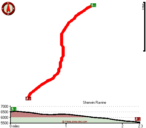
Trailhead 1 to Trailhead 2:
Total hiking length = 2.3 miles
Total climbing distance = .2 miles
Difficulty : Easy
Casual Hiking Pace: 1.5 hours
Fast Hiking Pace: 1 hours

Trailhead 2 to Trailhead 1:
Total hiking length = 2.3 miles
Total climbing distance = 1.8 miles
Difficulty : Difficult
Casual Hiking Pace: 2.5 hours
Fast Hiking Pace: 1.5 hours
    Trailhead 1 back to Trailhead 1:
Total hiking length = 4.6 miles
Total climbing distance = 2 miles
Difficulty : Medium
Casual Hiking Pace: 4 hours
Fast Hiking Pace: 2.5 hours

Trailhead 2 back to Trailhead 2:
Total hiking length = 4.6 miles
Total climbing distance = 2 miles
Difficulty : Medium
Casual Hiking Pace: 4 hours
Fast Hiking Pace: 2.5 hours

Total elevation difference: 1051 feet


Chalet View Lodge, Graeagle
29 miles away
A Luxurious, yet affordable, lodging experience awaits you at Chalet View Lodge ? a stylish getaway to the splendor of the Mohawk Valley. Immerse yourself in spacious, elegant accommodations and pers...
  
Deer Creek Inn, Nevada City
29 miles away
Deer Creek Inn is a 150 year old restored Queen Anne Victorian located in the historic Gold Rush town of Nevada City, California. The historic shopping and dining district on Broad Street is only foot...
User input for Claremont Trail, Northern Sierra Nevada, Plumas County, California:

Submit Input:
Your Name:
Write or Paste Input here:

Upload picture:      Review Guidelines


Outdoors Recreation Near Truckee-Grass Valley, California
Very comprehensive list of a variety of outdoors recreation in the vicinity of Truckee-Grass Valley, California, the metro area neareast to Claremont Trail. Find info on campgrounds, hiking trails, ski resorts, lakes, beaches, parks, whitewater and more.

Current weather conditions at Claremont Trail, Northern Sierra Nevada, Plumas County, California
WXPort

Local climate location: CANYON DAM 13 miles away

Best Western Rose Quartz, Chester
29 miles away
This Chester, California hotel is the perfect mountain get-away, offering a variety of amenities including a complimentary continental breakfast each morning. Nestled among the Sierra Nevada mountai...

Bailey Creek Cottages, Chester
31 miles away
Bailey Creek Cottages are located on the Public 18-Hole Bailey Creek Golf Course on the peninsula of Lake Almanor near Chester, California. Stay and play packages are available all through the golf se...

More Hotels and Campgrounds Near Claremont Trail, Northern Sierra Nevada, Plumas County, California

OTHER_INFO
  Northern Sierra Nevada Campgrounds
Complete list of all the campgrounds in the Northern Sierra Nevada.

Northern Sierra Nevada Outdoors Info
Complete outdoors info for the Northern Sierra Nevada.

California Hiking Trails
Complete list of all hiking trails in California

Books about hiking trails in California
List of books available on Amazon.com about hiking trails in California.

California Outdoors Index
This is a very comprehensive index of outdoors activities in the great state of California.


TOPO
High quality water resistant topo map of Claremont Trail, Northern Sierra Nevada, Plumas County, California.

OUTDOORS_GUIDE
These outdoors activities are available near Claremont Trail.
 Trails Near Claremont Trail:
Finger Board Trail, Plumas County , 4 miles away,  6.4 hiking miles, 3226 feet elevation difference
Cleghorn Bar Trail, Plumas County , 5 miles away,  6 hiking miles, 2074 feet elevation difference
 Camp Grounds Near Claremont Trail:
Chilcoot - Plumas National Forest, Quincy, 3 miles away
Cottonwood - Plumas National Forest, Quincy, 3 miles away
Frenchman - Plumas National Forest, Quincy, 3 miles away
Grizzly - Plumas National Forest, Quincy, 3 miles away
Hallsted - Plumas National Forest, Quincy, 3 miles away
 Whitewater Near Claremont Trail:
Feather River - Middle Fork, Plumas/ Butte County County , 9 miles away, Class V+ - 32.5 miles long (Nelson Point to Milsap Bridge)
Indian Creek Feather Tributary, Plumas County County , 9 miles away, Class V - 5.5 miles long (Close to Crescent Mills to Spanish Creek)
Feather River - Middle Fork, Plumas County County , 12 miles away, Class II-III - 6.5 miles long (Sloat to Nelson Point)
 National Parks Near Claremont Trail:
Lassen Volcanic National Park, Mineral - CA , 49 miles away
 Hotels Near Claremont Trail:
Chalet View Lodge, Graeagle , 29 miles away
Deer Creek Inn, Nevada City , 29 miles away
Best Western Rose Quartz, Chester , 29 miles away
Bailey Creek Cottages, Chester , 31 miles away
Nevada City Inn, Nevada City , 33 miles away

Outdoors related information copyright © Stratus-Pikpuk, Inc. - Detailed hotel information copyright © Interactive Hotel Solutions