California hiking trails - Chiquito Trail, Santa Ana Mountains, Orange County

   
  Chiquito Trail is a great outdoors hiking trail quite far from Los Angeles-Long Beach-Santa Ana, but when you spend some time trekking here you will feel like a whole new person. There are so many fine backcountry trails for backpacking in California; Chiquito Trail in Orange County is one of them. If you happen to be in California, why not go backpacking, it is always an enjoyable thing to do. The total elevation difference for this wilderness trail is 519 feet which is lower than average. At parts of the year this area sees very little rain, so don’t
    forget to check for any current fire restrictions before you go. This hike shouldn't take more than 1.5 hours, but you never know stuff could go wrong and you could get stuck so be prepared for that. There are numerous backcountry trails in California, and each one is stunning
in its own way. Chiquito Trail gets very little rain; the wettest month of the year is usually February, that's the one that rains the most; the driest of the months is July. Chiquito Trail is a very short backpacking trail with an average amount of climbing distance which makes this backcountry trail perfect for the average backcountry trekker looking for an enjoyable adventure. This is a one trailhead wilderness trail, so you'll be hiking it in and back out. Chiquito Trail stays roughly within the same elevation zone the whole time, so you won’t have  
to worry about different climate zones along your hike. Even though this is not a very long backcountry trail you should still bring some emergency supplies just in case something happens. With its 2 miles of walking distance it's shorter than many wilderness trails. The backpacking trails of the Santa Ana Mountains are the best way to enjoy these hills. This is one of many backcountry trails in the surrounding region. Backcountry backpacking in California is such a tremendous thing to do. Gotta get out of the city man, and Chiquito Trail in Orange County, California is just the location. Please follow all local rules about fires and camping. For the period of the months of summer, highs generally are in the 90's at Chiquito Trail. Once the sun is down it drops down to the 50's. Daytime highs during the wintertime are in the 60's, and nighttime lows in the 30's for Chiquito Trail.

Briefly about the general area:
Chiquito Trail is a great spot to camp, Upper San Juan Campground is a great spot, and a pleasant spot close by is Lion Canyon. This river is always fun.
This spot, the Santa Ana Mountains, has so much outdoors exciting stuff. Camping at Chiquito Trail is brilliant fun, Lower San Juan Campground is a brilliant local campground, and at Chiquito Trail you always meet someone from Los Angeles-Long Beach-Santa Ana.

Location of Trailhead: Latitude 33.6436, Longitude -117.4617
- - Directions and Road Map

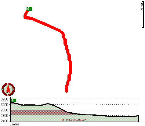
Total in and out hiking length = 2 miles

Total climbing distance = .7 miles

Difficulty : Medium

Casual Hiking Pace: 1.5 hours

Fast Hiking Pace: 1 hours

Total elevation difference: 519 feet


Travel Inn of Lake Elsinore, Lake Elsinore
11 miles away
Clean, comfortable rooms with queen beds, cable television, refrigerators, microwaves, tables and chairs, plenty of parking, and centrally located to a wide variety of attractions....
  
Holiday Inn Express Hotel & Suites LAKE ELSINORE, Lake Elsinore
11 miles away
Come experience the ambiance and thrill of Lake Elsinore, California and our NEW Holiday Inn Express and Suites conveniently located off Railroad Canyon/Diamond Drive Exit on I-15. Lake Elsinore will ...
User input for Chiquito Trail, Santa Ana Mountains, Orange County, California:

Submit Input:
Your Name:
Write or Paste Input here:

Upload picture:      Review Guidelines


Outdoors Recreation Near Los Angeles-Long Beach-Santa Ana, California
Very comprehensive list of a variety of outdoors recreation in the vicinity of Los Angeles-Long Beach-Santa Ana, California, the metro area neareast to Chiquito Trail. Find info on campgrounds, hiking trails, ski resorts, lakes, beaches, parks, whitewater and more.

Current weather conditions at Chiquito Trail, Santa Ana Mountains, Orange County, California
WXPort

Local climate location: CORONA 9 miles away

Quality Inn Lake Elsinore, Lake Elsinore
11 miles away
Lakeview hotel. Across from casino and walking distance to restaurants. Free deluxe continental breakfast served from 6:30 to 9:30 Monday - Friday, and 6:30 to 10:00 Saturday and Sunday. No pets allow...

Best Western Lake View Inn & Suites, Lake Elsinore
11 miles away
Discover this new Lake Elsinore hotel offering stylish accommodations offering beautiful views of the lake. The Best Western Lake View Inn & Suites is conveniently located near the Lake Elsinore Recr...

More Hotels and Campgrounds Near Chiquito Trail, Santa Ana Mountains, Orange County, California

OTHER_INFO
  Santa Ana Mountains Campgrounds
Complete list of all the campgrounds in the Santa Ana Mountains.

Santa Ana Mountains Outdoors Info
Complete outdoors info for the Santa Ana Mountains.

California Hiking Trails
Complete list of all hiking trails in California

Books about hiking trails in California
List of books available on Amazon.com about hiking trails in California.

California Outdoors Index
This is a very comprehensive index of outdoors activities in the great state of California.


TOPO
High quality water resistant topo map of Chiquito Trail, Santa Ana Mountains, Orange County, California.

OUTDOORS_GUIDE
These outdoors activities are available near Chiquito Trail.
 Trails Near Chiquito Trail:
San Juan Trail, Orange County , 3 miles away, 5.5 hiking miles, 2482 feet elevation difference
Trabuco Canyon Trail, Orange County , 3 miles away,  6.8 hiking miles, 2187 feet elevation difference
Morgan Trail, Riverside County , 4 miles away, 2.4 hiking miles, 712 feet elevation difference
Los Pinos Trail, Orange County , 4 miles away,  15 hiking miles, 3620 feet elevation difference
Horsethief Trail, Orange County , 4 miles away,  2.6 hiking miles, 1304 feet elevation difference
East Horsetheif Trail, Riverside County , 5 miles away,  7.8 hiking miles, 2793 feet elevation difference
Clark Trail, Riverside County , 6 miles away,  4.8 hiking miles, 877 feet elevation difference
 Camp Grounds Near Chiquito Trail:
Lower San Juan Campground, Orange County, 1 miles away
Upper San Juan Campground, Riverside County, 1 miles away
Blue Jay Campground, Orange County, 2 miles away
Falcon Campground, Orange County, 2 miles away
El Cariso Campground, Riverside County, 4 miles away
 National Parks Near Chiquito Trail:
Cabrillo National Monument, San Diego - CA , 53 miles away
 Hotels Near Chiquito Trail:
Coto De Caza Guest Lodge, Trabuco Canyon , 9 miles away
Travel Inn of Lake Elsinore, Lake Elsinore , 11 miles away
Holiday Inn Express Hotel & Suites LAKE ELSINORE, Lake Elsinore , 11 miles away
Quality Inn Lake Elsinore, Lake Elsinore , 11 miles away
Best Western Lake View Inn & Suites, Lake Elsinore , 11 miles away

Outdoors related information copyright © Stratus-Pikpuk, Inc. - Detailed hotel information copyright © Interactive Hotel Solutions