| |
|
| | Can’t wait to get out in the wilderness, Charity Valley Trail in Alpine County, California is such a perfect place. There are so many fine great outdoors hiking trails for backcountry trekking in California; one of those is Charity Valley Trail in Alpine County. Charity Valley Trail is positioned a quite long trip from Gardnerville Ranchos, but backcountry hiking is such a fun thing to do, and this is a perfect place to do that. The backpacking and hiking trails of the Northern Sierra Nevada are a brilliant way to explore these mountaintops. There are |
|
plenty of great outdoors hiking trails in California; each one of them is well worth a backcountry hike. Keep in mind that this is a long wilderness hiking trail, so do pack enough food to last the whole trip. Charity Valley Trail goes through some very different elevations, so
| | keep in mind that you may need to dress differently at different elevations. 
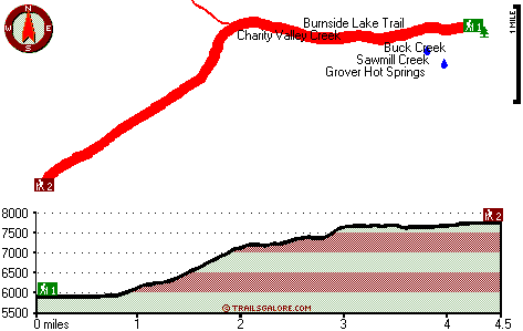
Charity Valley Trail has a total elevation difference of 2,275 feet which is an average number. This wilderness hiking trail sometimes gets very dry, so do check for current fire restrictions before you go if you plan to bring a stove or make a camp fire. Please follow all local rules about fires and camping. You should count on this hike taking about 7.5 hours, but of course some folks walk a bit slower and some a bit faster. There are not too many hiking trails in this neighborhood. | |
|
Being 9 miles long it's a mid length walk. Charity Valley Trail is a two ended wilderness trail with two trailheads, so if you can get a ride from someone, you can backcountry walk it just one way. When you're here in California backcountry trekking along one of its great outdoors
hiking trails never gets boring. All through the summer here at Charity Valley Trail, high temperatures commonly get into the 70's. Once the sun is down it dips down to the 40's. Highs through the winter are mostly in the 30's with winter lows in the 10's overnight here at Charity
Valley Trail. While visiting this region in California it's a brilliant idea to go backcountry trekking too. All the water falling down from the sky makes Charity Valley Trail a wet location; January is when you get the most snow here; the driest month is July. The length of Charity
Valley Trail is about average with an average amount of climbing distance which makes this hiking trail good for hard core backpackers looking for adventure.
Briefly about the general area: Charity Valley Creek is next to Charity Valley Trail and is always a delight
to go to, and a spree to Charity Valley revives the soul. Not enough hours in a day to enjoy the Northern Sierra Nevada. Some close by water includes Sawmill Creek, and don't leave Charity Valley Trail without first paying a visit to Soda Spring. There's whitewater on Carson
River - East Fork for all you adrenaline kick people, and nearby you find Millberry Canyon which is a perfect place to stop at. All the outdoors amusing things in the Northern Sierra Nevada will keep you coming back many times. There are some wonderful whitewater spots on Carson
River - East Fork; Charity Valley Trail is a place with many visitors from Gardnerville Ranchos. There's just no way someone can get bored here at Charity Valley Trail. If you came to camp Snowshoe Springs Campground is a brilliant location to do that It's always pleasant to
have a look at Grover Hot Springs. There's so much to do here at Charity Valley Trail that you need to camp here for a while, Toiyabe Campground is a pleasant location for that; everybody loves Faith Valley.
|
|
Location of Trailhead 1: Latitude 38.7016, Longitude -119.8386 - - Directions and Road Map
Location of Trailhead 2: Latitude 38.6781, Longitude -119.9014 - - Directions and Road Map

Trailhead 1 to Trailhead 2: Total hiking length = 4.5 miles Total climbing distance = 2.8 miles Difficulty : Medium Casual Hiking Pace:
4.5 hours
Fast Hiking Pace:
2.5 hours
Trailhead 2 to Trailhead 1: Total hiking length = 4.5 miles Total climbing distance = .5 miles Difficulty : Easy Casual Hiking Pace:
3 hours
Fast Hiking Pace:
1.5 hours
| | Trailhead 1 back to Trailhead 1: Total hiking length = 9 miles Total climbing distance = 3.3 miles Difficulty : Difficult Casual Hiking Pace:
7.5 hours
Fast Hiking Pace:
5 hours
Trailhead 2 back to Trailhead 2: Total hiking length = 9 miles Total climbing distance = 3.3 miles Difficulty : Difficult Casual Hiking Pace:
7.5 hours
Fast Hiking Pace:
5 hours
|
Total elevation difference: 2275 feet

Harvest Inn-St Helena, Napa Valley, Saint Helena
|
13 miles away
The Harvest Inn is the perfect setting for a well-deserved getaway in the heart of the Napa Valley. Winding brick pathways through cool redwood groves and 8 acres of beautiful award winning gardens in...
|
| |
Tahoe Seasons Resort (Vri), South Lake Tahoe
|
14 miles away
Tahoe Seasons Resort on Lake Tahoe's south shore offers elegant all Suite hotel accommodations and is across from the world class Heavenly Ski Resort at the California Base Lodge. While staying at...
|
|
User input for Charity Valley Trail, Northern Sierra Nevada, Alpine County, California:

Outdoors Recreation Near Gardnerville Ranchos, Nevada Very comprehensive list of a variety of outdoors recreation in the vicinity of Gardnerville Ranchos, Nevada, the metro area neareast to Charity Valley Trail. Find info on campgrounds, hiking trails, ski resorts, lakes, beaches, parks, whitewater and more.
More Hotels and Campgrounds Near Charity Valley Trail, Northern Sierra Nevada, Alpine County, California
| |
| |
 |
|
| These outdoors activities are available near Charity Valley Trail. |
| | Trails Near Charity Valley Trail:
 |
Burnside Lake Trail, Alpine
County
, 1 miles away, 3.4 hiking miles, 2762 feet elevation difference |
 |
Pacific Crest Trail - section 13,
County
, 9 miles away, 66 hiking miles, 3818 feet elevation difference |
 |
Hawley Grade Trail, El Dorado
County
, 11 miles away, 1.8 hiking miles, 920 feet elevation difference |
|
| | Whitewater Near Charity Valley Trail:
 |
Carson River - East Fork, Alpine County
County
, 8 miles away, Class II - 20 miles long (Hangman's Bridge to Gardnerville) |
 |
Carson River - East Fork, Alpine County
County
, 10 miles away, Class III - 7.3 miles long (Cave Rock to Hangman's Bridge) |
 |
Carson River - East Fork, Alpine County
County
, 12 miles away, Class II - 20 miles long (Hangman's Bridge to CA-NV border) |
 |
Mokelumne River - North Fork, Alpine/ Amador/ Calaveras County
County
, 15 miles away, Class V+ - 24.9 miles long (Route 4 Bridge to Salt Springs Reservoir) |
 |
Stanislaus River - Middle Fork, Tuolumne County
County
, 20 miles away, Class IV-V - 13 miles long (Baker Campground to Donnells Lake) |
|
| | Hotels Near Charity Valley Trail:
 |
Harvest Inn-St Helena, Napa Valley, Saint Helena
, 13 miles away |
 |
Tahoe Seasons Resort (Vri), South Lake Tahoe
, 14 miles away |
 |
The Deerfield Lodge at Heavenly, South Lake Tahoe
, 14 miles away |
 |
Lodge At Lake Tahoe, The (Vri), South Lake Tahoe
, 15 miles away |
 |
Americana Village, South Lake Tahoe
, 15 miles away |
|
|
|
 |
|