| |
|
| | (...) Chalone Peak Trail leads from Bear Gulch reservoir (close to Bear Gulch picnic area) to Chalone peaks (first North Peak, then South Peak). Neither peak is accessible by an automobile, which means that nobody can ''pick you up'' there, unless they do it in a helicopter. In reality Chalone Peak trail has only one accessible trailhead, which means that it has to be trekked both ways in any case. Says Andrey
Each one of the many backcountry hiking trails of California has its own unique prettiness. California has lots of outdoors endeavors. |
|
Backcountry trails are brilliant and plentiful in California; Chalone Peak Trail is one of them, and it's in Monterey County. Hiking in California never gets boring. The number of wilderness trails in this vicinity is not very high. For the period of the warm days of summer, highs
| | commonly are in the 90's at Chalone Peak Trail, and all through summer nights temperatures are in the 50's. Through the winter highs are in the 60's, and overnight lows in the 30's for Chalone Peak Trail. Different parts of this hiking trail are at very different elevations, so keep in mind that you may need to dress differently at different elevations. At parts of the year this region sees very little rain, so do check for current fire restrictions before you go if you plan to bring a stove or make a camp fire. Chalone Peak Trail has two trailheads, | |
|
so if you can get a ride from someone, you can backcountry trek it just one way. The time needed for this hike is roughly 4.5 hours, but you never know stuff could go wrong and you could get stuck so be prepared for that. It's a long tour from Salinas to Chalone Peak Trail, but
backcountry backpacking is such an enjoyable thing to do, and this is a perfect place to do that. Being 5.4 miles long it's an average length hiking trail. Spending too much time indoors got you down? No problem, Chalone Peak Trail in Monterey County, California is such a perfect
place. Don’t forget to check for any current restrictions or closures before you go. This is not a very long great outdoors hiking trail but you should still bring some emergency supplies just in case something happens. Chalone Peak Trail is pretty dry regularly; during January
this area sees the most rain, and July on the other hand is the driest. The total elevation difference for this hiking trail is 1,720 feet which is an average number. The length of this trail is about average with an average amount of climbing distance which makes it an excellent
wilderness trail for the average person looking for an excellent adventure.
Briefly about the general area: If you're here at Chalone Peak Trail, you could explore West Fork Chalone Creek; don't leave Chalone Peak Trail without first paying a visit to Moses Spring. Any
time is a nice time at Chalone Peak Trail if you love the outdoors. A delightful place to camp here at Chalone Peak Trail is Chalone Annex Campground. It's always great to visit Oak Tree Spring, and if you have time to spare, Pinnacles National Monument is a national park worth
visiting. Bear Gulch is a glorious place to stop at in the neighborhood of Chalone Peak Trail, and it's a glorious idea to stop at North Fork Chalone Creek. Chalone Peak Trail is good enough to spend more than a day at, Chalone Creek Campground is a good local campground; there's some attention-grabbing stuff to spot at Bear Gulch Dam near Chalone Peak Trail.
|
|
Location of Trailhead 1: Latitude 36.4775, Longitude -121.185 - - Directions and Road Map
Location of Trailhead 2: Latitude 36.455, Longitude -121.198 - - Directions and Road Map

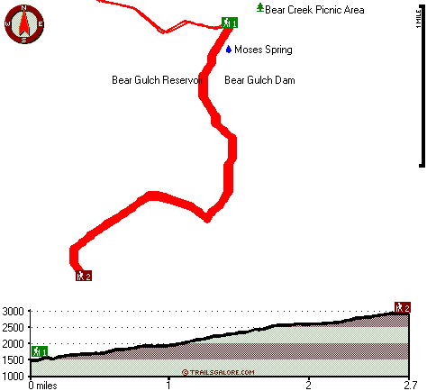
Trailhead 1 to Trailhead 2: Total hiking length = 2.7 miles Total climbing distance = 2 miles Difficulty : Difficult Casual Hiking Pace:
3 hours
Fast Hiking Pace:
1.5 hours
Trailhead 2 to Trailhead 1: Total hiking length = 2.7 miles Total climbing distance = .2 miles Difficulty : Easy Casual Hiking Pace:
2 hours
Fast Hiking Pace:
1 hours
| | Trailhead 1 back to Trailhead 1: Total hiking length = 5.4 miles Total climbing distance = 2.2 miles Difficulty : Medium Casual Hiking Pace:
4.5 hours
Fast Hiking Pace:
3 hours
Trailhead 2 back to Trailhead 2: Total hiking length = 5.4 miles Total climbing distance = 2.2 miles Difficulty : Medium Casual Hiking Pace:
4.5 hours
Fast Hiking Pace:
3 hours
|
Total elevation difference: 1720 feet

Valley Harvest Inn, Soledad
|
10 miles away
Welcome to the Valley Harvest Inn, located in Soledad, CA, the heart of the Salinas Valley and Monterey County wine country. Close to Pinnacles National Monument, Mission Soledad, and Monterey Bay, th...
|
| |
Days Inn King City, King City
|
15 miles away
Welcome to Days Inn King City where we have 46 beautiful rooms for your convenience. We are conveniently located off Hwy 101 halfway between Los Angeles and San Francisco in the middle of wine country...
|
|
User input for Chalone Peak Trail, Monterey County, California:

Outdoors Recreation Near Salinas, California Very comprehensive list of a variety of outdoors recreation in the vicinity of Salinas, California, the metro area neareast to Chalone Peak Trail. Find info on campgrounds, hiking trails, ski resorts, lakes, beaches, parks, whitewater and more.
|
Current weather conditions at Chalone Peak Trail, Monterey County, California

Local climate location: PINNACLES NATL MON 10 miles away

           
| |
Quality Inn King City, King City
|
15 miles away
The Quality Inn features free continental breakfast, free high-speed Internet and an outdoor pool. The rooms have hair dryers, coffee makers, irons and boards and all rooms feature microwaves and refr...
|
Courtesy Inn, King City
|
15 miles away
Newly renovated, Certified small business,Courtesy Inn and Suite has 63 rooms, pool, whirlpool hot tub, We are near US 101 Canal Street exit on the west side of the highway. The Courtesy Inn and Sui...
|
|
More Hotels and Campgrounds Near Chalone Peak Trail, Monterey County, California
| |
|
| These outdoors activities are available near Chalone Peak Trail. |
| | Trails Near Chalone Peak Trail:
 |
High Peaks Trail, San Benito
County
, 1 miles away, 3.8 hiking miles, 1535 feet elevation difference |
 |
Tunnel Trail, San Benito
County
, 1 miles away, 3.6 hiking miles, 1385 feet elevation difference |
 |
Balconies Trail, San Benito
County
, 2 miles away, 1.4 hiking miles, 316 feet elevation difference |
|
| | Hotels Near Chalone Peak Trail:
 |
Valley Harvest Inn, Soledad
, 10 miles away |
 |
Days Inn King City, King City
, 15 miles away |
 |
Quality Inn King City, King City
, 15 miles away |
 |
Courtesy Inn, King City
, 15 miles away |
 |
Keefers Inn, King City
, 15 miles away |
|
|
|
 |
|