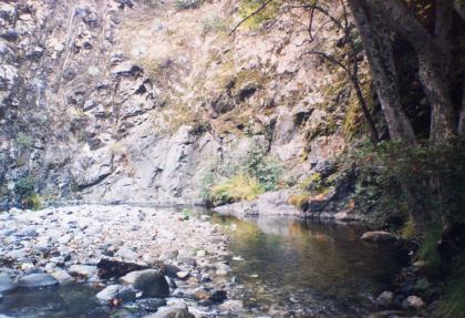
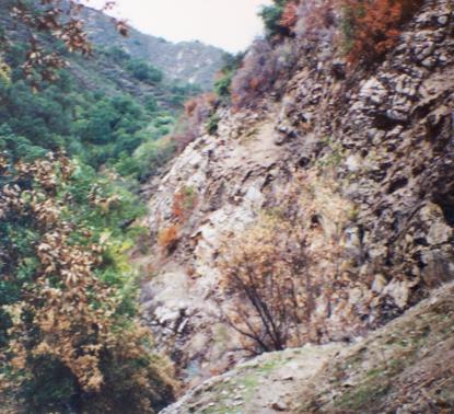
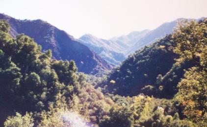
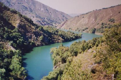
California hiking trails - Carmel River Trail, Santa Lucia Range, Monterey County

   
  Spending too much time indoors got you down? No problem, Carmel River Trail in Monterey County, California is just what you need. Carmel River Trail is a great outdoors hiking trail rather far from Salinas, but it's one of those locations where backpacking is delightful. Every California hiking and backpacking trail has its own unique attractiveness. If you happen to be in California, why not go backcountry backpacking, it is the great thing to do. The total elevation difference for Carmel River Trail is 3,023 feet which is higher than average. This
    is just one of a large number of hiking trails in this vicinity. This is a hiking trail that is quite long, so don't forget to pack enough supplies. Not much rainfall falls here at Carmel River Trail; January is when you get the most rain here, and July is the month with the least
moisture. This great outdoors trail is a great outdoors trail of brilliant length having an average number of uphill miles which makes this hiking trail delightful for hard core backpackers looking for adventure. Now, this is roughly a 4.5-day backcountry trek, so it's a glorious thing if your backpack is big enough to do the job. Throughout the summer at Carmel River Trail temperatures are typically in the 70's. Once the sun is down it descends down to the 50's. Highs all through the winter are mostly in the 50's, and after the sun is down all through  
the winter temperatures at Carmel River Trail descend into the 40's. Please follow all local rules about fires and camping. This is a one trailhead wilderness trail, so you'll be hiking it in and back out. With its 29.4 miles of walking distance; it's longer than many wilderness trails. Sometimes this hiking trail gets really dry, so don’t forget to check for any current fire restrictions before you go. Trekking here in California is a must. Different parts of this wilderness trail are at very different elevations, and that means that some parts of the wilderness trail could be very different from other parts of it. There are many great hiking and backpacking trails in California, and one of those is Carmel River Trail in Monterey County. The stunning great outdoors trails of the Santa Lucia Range are the best way to enjoy these mountaintops.

Briefly about the general area:
And if that's not enough there's loads more amusing things to do in the Santa Lucia Range. If you're interested in hydro structures, you can visit Los Padres Dam; a pleasant visit to Pine Valley is a nice way to spend an afternoon. A wonderful location in the vicinity of Carmel River Trail is Miller Canyon.
If you came for an overnight stay Tin House Campground is a wonderful spot to camp, and the good folks of Salinas like to hang out nearby. Don't forget to take a glorious little spree to Danish Creek, and Bear Basin is a great spot to stretch your legs a bit. You'll wish for more hours in a day to enjoy all the exciting stuff at Carmel River Trail. Get yourself into a kayak and hit Carmel River, and why not camp at Rattlesnake Campground while you're here at Carmel River Trail.
Do schedule some time to visit Grimes Point near Carmel River Trail if you have a chance, and some great nature is available in Big Pines. Pine Falls is an inspiring place to pop by while here, and it's a good idea to visit Miller Fork Carmel River. Now, you may imagine that's a heap but there's even more entertaining stuff to do here in the Santa Lucia Range. If you come at the right time of year, Big Sur River offers some good whitewater, and a visit to Carmel River Trail wouldn't be complete without taking a look at Sulphur Spring.

Location of Trailhead: Latitude 36.3887, Longitude -121.6701
- - Directions and Road Map

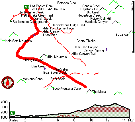
Total in and out hiking length = 29.4 miles

Total climbing distance = 12.9 miles

Difficulty : Difficult

Casual Hiking Pace: 4.5 days

Fast Hiking Pace: 3 days

Total elevation difference: 3023 feet


Country Garden Inns, Carmel Valley
8 miles away
Nestled in the sunny Santa Lucia Mountains-just minutes from Carmel by the Sea California. Country Garden Inns offers two bed and breakfast inns with European hospitality. Both Hidden Valley Inn and A...
  
Bernardus Lodge, Carmel Valley
10 miles away
Nestled on verdant acres with stately pines and California oak trees, surrounded by a vineyard and the Santa Lucia mountains rising majestically in the background, Bernardus Lodge is a premier luxury ...
User input for Carmel River Trail, Santa Lucia Range, Monterey County, California:


This is a view from the campground a few miles into the hike, I'm not sure what the camp ground was called but it was very pretty. - Bob


This is a bit of a scary but very beautiful section that comes a bit south of the lake. - Bob


This picture is taken a couple of miles into the hike after you've left the lake behind. - Bob


This is a shot from soon after you leave the dam behind, you can't see it in the picture but the trail kinda follows the right side of the lake. - Bob

Submit Input:
Your Name:
Write or Paste Input here:

Upload picture:      Review Guidelines


Outdoors Recreation Near Salinas, California
Very comprehensive list of a variety of outdoors recreation in the vicinity of Salinas, California, the metro area neareast to Carmel River Trail. Find info on campgrounds, hiking trails, ski resorts, lakes, beaches, parks, whitewater and more.

Current weather conditions at Carmel River Trail, Santa Lucia Range, Monterey County, California
WXPort

Local climate location: MONTEREY 8 miles away

Ventana Inn Big Sur, Big Sur
15 miles away
Situated on 243 acres, 1,200 feet above the Pacific Ocean. The property is known for its serene setting, rustic yet luxurious sophistication and romantic allure. Features include 26 newly remodeled su...

Salinas-Days Inn Monterey, California, Salinas
16 miles away
Welcome to Days Inn Salinas Airport. We are centrally located in Monterey County close to all major area attractions. For your convenience, we offer Complimentary High Speed Wireless Internet Access, ...

More Hotels and Campgrounds Near Carmel River Trail, Santa Lucia Range, Monterey County, California

OTHER_INFO
  Santa Lucia Range Campgrounds
Complete list of all the campgrounds in the Santa Lucia Range.

Santa Lucia Range Outdoors Info
Complete outdoors info for the Santa Lucia Range.

California Hiking Trails
Complete list of all hiking trails in California

Books about hiking trails in California
List of books available on Amazon.com about hiking trails in California.

California Outdoors Index
This is a very comprehensive index of outdoors activities in the great state of California.


TOPO
High quality water resistant topo map of Carmel River Trail, Santa Lucia Range, Monterey County, California.

OUTDOORS_GUIDE
These outdoors activities are available near Carmel River Trail.
 Trails Near Carmel River Trail:
Hennicksons Ridge Trail, Monterey County , 2 miles away, 5.9 hiking miles, 2356 feet elevation difference
Rattlesnake Creek Trail, Monterey County , 2 miles away,  7 hiking miles, 1350 feet elevation difference
Miller Canyon Trail, Monterey County , 4 miles away,  15.6 hiking miles, 2327 feet elevation difference
San Clemente Trail, Monterey County , 5 miles away,  7 hiking miles, 714 feet elevation difference
Pine Ridge Trail, Monterey County , 5 miles away, 20.1 hiking miles, 4802 feet elevation difference
Church Creek Trail, Monterey County , 6 miles away,  3.8 hiking miles, 1279 feet elevation difference
Big Sur Trail, Monterey County , 8 miles away,  15.2 hiking miles, 1949 feet elevation difference
 Camp Grounds Near Carmel River Trail:
Rattlesnake Campground, Monterey County, 2 miles away
Tin House Campground, Monterey County, 8 miles away
China Camp, Monterey County, 9 miles away
Logwood Campground, Monterey County, 9 miles away
Vado Campground, Monterey County, 10 miles away
 Whitewater Near Carmel River Trail:
Carmel River, Monterey County County , 4 miles away, Class II-III(IV) - 10 miles long (Los Padres Reservoir to Carmel Valley)
Big Sur River, Monterey County County , 11 miles away, Class II+ - 4 miles long (Pfeiffer Big Sur State Park to Motels)
Little Sur River, Monterey County County , 13 miles away, Class III-IV - 7 miles long (Pico Blanco BSouth Carolina to Highway 1)
Arroyo Seco River, Monterey County County , 14 miles away, Class IV(V) - 3 miles long (Willowcreek Bridge to Arroyo Seco Picnic Area)
Arroyo Seco River, Monterey County County , 19 miles away, Class III - 14.5 miles long (Arroyo Seco Picnic Area to Route G16 bridge)
 National Parks Near Carmel River Trail:
Pinnacles National Monument, Paicines - CA , 45 miles away
 Hotels Near Carmel River Trail:
Country Garden Inns, Carmel Valley , 8 miles away
Bernardus Lodge, Carmel Valley , 10 miles away
Ventana Inn Big Sur, Big Sur , 15 miles away
Salinas-Days Inn Monterey, California, Salinas , 16 miles away
Howard Johnson Inn, Salinas , 17 miles away

Outdoors related information copyright © Stratus-Pikpuk, Inc. - Detailed hotel information copyright © Interactive Hotel Solutions