California hiking trails - Canyon Creek Trail, Northern Sierra Nevada, Nevada County

   
  Each one of the many hiking and backpacking trails of California has its own unique beauty. Hiking trails are pleasant and plentiful in California, and Canyon Creek Trail is one of them, and it's in Nevada County. If you happen to be in California, why not go hiking, it is something that is always fun to do. Sometimes this backpacking and hiking trail gets really dry, so do check for current fire restrictions before you go if you plan to bring a stove or make a camp fire. There are so many wilderness hiking trails in this vicinity. There are two trailheads
    to chose from, one in each end, so trekking it one way is an option if you can arrange for a ride back. Canyon Creek Trail is not very next to Truckee-Grass Valley at all, but it is an enjoyable place to backcountry walk. With its 9.8 miles of walking distance; it's a long backcountry
hiking trail. In California you never run out of outdoors fun. This is a long backpacking and hiking trail, so don't forget to pack enough supplies. Hey, time for a backcountry walk don’t you think? Canyon Creek Trail in Nevada County, California is a splendid place for getting out. Great outdoors trails like this one here in the Northern Sierra Nevada are a very great way to see these summits. Don’t forget to check for any current restrictions or closures before you go. This trek shouldn't take more than 8.5 hours, but of course some people walk a bit  
slower and some a bit faster. Canyon Creek Trail is a trail of great length having an average number of uphill miles which makes this wilderness hiking trail great for hard core backpackers looking for adventure. All through the summertime months at Canyon Creek Trail highs are ordinarily in the 90's. When the night sets in temperatures sink down into the 40's. All through the wintertime this place gets highs in the 40's, and nighttime lows at Canyon Creek Trail during the wintertime commonly sink into the 20's. Canyon Creek Trail goes through some very different elevations, so keep in mind that you may need to dress differently at different elevations. The total elevation difference for Canyon Creek Trail is 1,929 feet which is an average number. Canyon Creek Trail gets a typical amount of annual rainfall; the wettest month of the year is ordinarily January, that's the one that rains the most, and July is when it's the driest.

Briefly about the general area:
While you're here at Canyon Creek Trail it's a splendid idea to check out Murphy Flat; float down the rapids of Yuba River - South Fork in a kayak. Texas Creek flows through this vicinity It's always great to check out Willow Spring.
Just can't get enough of the Northern Sierra Nevada. Canyon Creek Trail is a tremendous place to visit for more than one day, Lindsey Campground is a tremendous place to camp nearby, and if you come at the right time of year, Fordyce Creek offers some great whitewater. You have to undeniably dedicate some time to Pat Yore Flat since you're here at Canyon Creek Trail. But wait, there's more to do close to Canyon Creek Trail. You'll need more than a day to explore everything Canyon Creek Trail has to offer, you can camp at Carr-Feeley Campground; let's not forget Lindsey Creek which is a stream that you may bump into while here.
And that's not everything there is to do here in the Northern Sierra Nevada. Canyon Creek Trail is a place with many visitors from Truckee-Grass Valley, and do put some time aside to spend at Black Oak Spring if you're here at Canyon Creek Trail. Poison Canyon is a great spot to look at; Erie Point is around here and always nice to explore.

Location of Trailhead 1: Latitude 39.4284, Longitude -120.671
- - Directions and Road Map

Location of Trailhead 2: Latitude 39.3729, Longitude -120.7085
- - Directions and Road Map


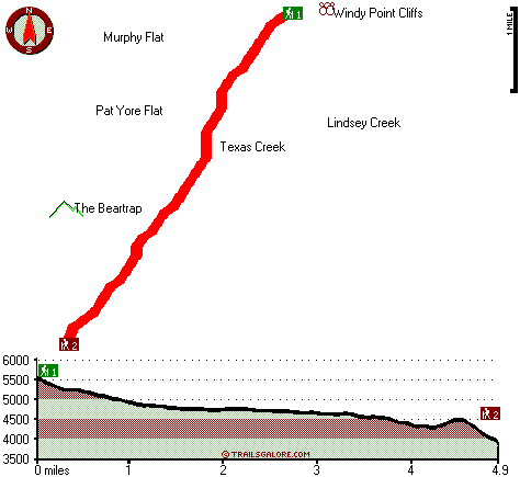
Trailhead 1 to Trailhead 2:
Total hiking length = 4.9 miles
Total climbing distance = .6 miles
Difficulty : Easy
Casual Hiking Pace: 3.5 hours
Fast Hiking Pace: 2 hours

Trailhead 2 to Trailhead 1:
Total hiking length = 4.9 miles
Total climbing distance = 3.2 miles
Difficulty : Medium
Casual Hiking Pace: 5 hours
Fast Hiking Pace: 3 hours
    Trailhead 1 back to Trailhead 1:
Total hiking length = 9.8 miles
Total climbing distance = 3.8 miles
Difficulty : Difficult
Casual Hiking Pace: 8.5 hours
Fast Hiking Pace: 5.5 hours

Trailhead 2 back to Trailhead 2:
Total hiking length = 9.8 miles
Total climbing distance = 3.8 miles
Difficulty : Difficult
Casual Hiking Pace: 8.5 hours
Fast Hiking Pace: 5.5 hours

Total elevation difference: 1929 feet


Deer Creek Inn, Nevada City
12 miles away
Deer Creek Inn is a 150 year old restored Queen Anne Victorian located in the historic Gold Rush town of Nevada City, California. The historic shopping and dining district on Broad Street is only foot...
  
Chalet View Lodge, Graeagle
23 miles away
User input for Canyon Creek Trail, Northern Sierra Nevada, Nevada County, California:

Submit Input:
Your Name:
Write or Paste Input here:

Upload picture:      Review Guidelines


Outdoors Recreation Near Truckee-Grass Valley, California
Very comprehensive list of a variety of outdoors recreation in the vicinity of Truckee-Grass Valley, California, the metro area neareast to Canyon Creek Trail. Find info on campgrounds, hiking trails, ski resorts, lakes, beaches, parks, whitewater and more.

Current weather conditions at Canyon Creek Trail, Northern Sierra Nevada, Nevada County, California
WXPort

Local climate location: QUINCY 11 miles away

Nevada City Inn, Nevada City
24 miles away
A home away from home! Comfortable, park-like setting, 2/3 of a mile to downtown Nevada City, 27 guest rooms inluding 7 cottages. We are now an all non smoking room hotel. We are a pet friendly hotel...

Piety Hill Cottages, Nevada City
25 miles away
9 Tastefully appointed BnB cottages in this parklike setting 1 acre with tree-shaded grassy courtyard...

More Hotels and Campgrounds Near Canyon Creek Trail, Northern Sierra Nevada, Nevada County, California

OTHER_INFO
  Northern Sierra Nevada Campgrounds
Complete list of all the campgrounds in the Northern Sierra Nevada.

Northern Sierra Nevada Outdoors Info
Complete outdoors info for the Northern Sierra Nevada.

California Hiking Trails
Complete list of all hiking trails in California

Books about hiking trails in California
List of books available on Amazon.com about hiking trails in California.

California Outdoors Index
This is a very comprehensive index of outdoors activities in the great state of California.


TOPO
High quality water resistant topo map of Canyon Creek Trail, Northern Sierra Nevada, Nevada County, California.

OUTDOORS_GUIDE
These outdoors activities are available near Canyon Creek Trail.
 Trails Near Canyon Creek Trail:
Eagle Bird Trail, Nevada County , 3 miles away, 1.6 hiking miles, 1371 feet elevation difference
Round Lake Trail, Nevada County , 4 miles away,  4 hiking miles, 406 feet elevation difference
Bowman Mountain Trail, Nevada County , 5 miles away, 3.6 hiking miles, 1277 feet elevation difference
Crooked Lakes Trail, Nevada County , 5 miles away,  7.4 hiking miles, 350 feet elevation difference
Spaulding Lake Trail, Nevada County , 5 miles away,  3.6 hiking miles, 601 feet elevation difference
Bedbug Smith Trail, Sierra County , 6 miles away,  6.2 hiking miles, 1927 feet elevation difference
Bayes Cabin Road, Nevada County , 6 miles away,  3.4 hiking miles, 1568 feet elevation difference
 Camp Grounds Near Canyon Creek Trail:
Lindsey Campground, Nevada County, 3 miles away
Carr-Feeley Campground, Nevada County, 3 miles away
Fuller Lake Campground, Nevada County, 3 miles away
Weaver lake Campground, Nevada County, 4 miles away
McMurray Campground, Nevada County, 4 miles away
 Whitewater Near Canyon Creek Trail:
Yuba River - South Fork, Nevada/ Placer County County , 8 miles away, Class IV-V(V+) - 7.5 miles long (Cisco Grove to Spaulding Reservoir)
Fordyce Creek, Nevada County County , 9 miles away, Class IV-V - 12 miles long (Fordyce Lake to Lake Spaulding)
Yuba River - North Fork, Sierra County County , 9 miles away, Class IV-V - 13 miles long (Wild Plum Campground to Downieville)
American River - North Fork, Placer County County , 11 miles away, Class IV-V - 12.3 miles long (Tadpole Creek to Euchre Bar)
Pauley Creek, Sierra County County , 13 miles away, Class III-IV - 4 miles long (Second Divide Turnout to Downieville)
 Hotels Near Canyon Creek Trail:
Deer Creek Inn, Nevada City , 12 miles away
Chalet View Lodge, Graeagle , 23 miles away
Nevada City Inn, Nevada City , 24 miles away
Piety Hill Cottages, Nevada City , 25 miles away
Best Western Gold Country Inn, Grass Valley , 26 miles away
 Lakes Near Canyon Creek Trail
Rucker Lake, Nevada County , 3 miles away
Lindsey Lakes, Nevada County , 3 miles away

Outdoors related information copyright © Stratus-Pikpuk, Inc. - Detailed hotel information copyright © Interactive Hotel Solutions