California hiking trails - Cadd Fire Trail, Sonoma County

   
  Cadd Fire Trail is to be found a relatively lengthy journey from Clearlake, but many people like to trek here to be in close proximity to nature. There are hiking trails all over California, and Cadd Fire Trail in Sonoma County is one of them. Going for a backcountry walk here in California is a magnificent way to spend some time. Backpacking in California is such a magnificent thing to do. This is a backpacking trail that is quite long, so don't forget to pack enough supplies. Being 7.2 miles long it's an average length great outdoors hiking trail.
    The great outdoors hiking trail stays roughly within the same elevation zone the whole time which means the conditions are about the same from start to finish. Cadd Fire Trail is a normal length wilderness trail having an average number of uphill miles which makes this wilderness
hiking trail nice for hard core backpackers looking for adventure. There are numerous hiking trails in California, and each one is worth backcountry backpacking. Alright, enough of spending all this time inside a building, time to get out, and Cadd Fire Trail in Sonoma County, California is just the spot. There are not too many wilderness hiking trails in this vicinity. At parts of the year this vicinity sees very little rain, so don’t forget to check for any current fire restrictions before you go. At Cadd Fire Trail throughout the days of summer highs  
are in the 90's while nighttime lows are ordinarily in the 50's. During the winter highs are in the 50's, and nighttime lows through the winter for Cadd Fire Trail tend to be in the 30's. Cadd Fire Trail is a two ended wilderness hiking trail with two trailheads, so if you can get a ride from someone, you can hike it just one way. The total elevation difference for Cadd Fire Trail is 640 feet which is lower than average. And keep in mind that there could be temporary safety restrictions in spot. A typical amount of precipitation falls here at Cadd Fire Trail; throughout January this vicinity sees the most rain, and the driest month of the year is July. This walk shouldn't take more than 6.5 hours, but of course some people walk a bit slower and some a bit faster.

Briefly about the general area:
So many amusing things to do here at Cadd Fire Trail, too nice to be true. If you wish for a little side visit, try Geyser Canyon, and you can stay the night at Beaver Creek RV Park and Campground.
Take a side visit to Hot Springs Creek, and Pine Flat is a great spot to check out. Whitewater paddling is not for everyone but if it's for you then we recommend Big Sulphur Creek, and The Geysers is a pretty location to take a look at while you're at Cadd Fire Trail. Get your pulse rate up on the magnificent whitewater of Little Sulphur Creek, and do explore Cobb Creek since you're here at Cadd Fire Trail.
Cold Springs is a pleasant local attraction; you are in close proximity to The Horn since you're here. Cadd Fire Trail is a good location to visit for more than one day, Beavercreek RV Park and Camp is a good location to camp nearby, and at Cadd Fire Trail you always meet someone from Clearlake.

Location of Trailhead 1: Latitude 38.7846, Longitude -122.8145
- - Directions and Road Map

Location of Trailhead 2: Latitude 38.7603, Longitude -122.7686
- - Directions and Road Map


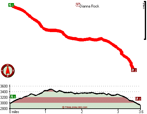
Trailhead 1 to Trailhead 2:
Total hiking length = 3.6 miles
Total climbing distance = 1.5 miles
Difficulty : Medium
Casual Hiking Pace: 3 hours
Fast Hiking Pace: 1.5 hours

Trailhead 2 to Trailhead 1:
Total hiking length = 3.6 miles
Total climbing distance = 1.8 miles
Difficulty : Medium
Casual Hiking Pace: 3.5 hours
Fast Hiking Pace: 2 hours
    Trailhead 1 back to Trailhead 1:
Total hiking length = 7.2 miles
Total climbing distance = 3.3 miles
Difficulty : Difficult
Casual Hiking Pace: 6.5 hours
Fast Hiking Pace: 4.5 hours

Trailhead 2 back to Trailhead 2:
Total hiking length = 7.2 miles
Total climbing distance = 3.3 miles
Difficulty : Difficult
Casual Hiking Pace: 6.5 hours
Fast Hiking Pace: 4.5 hours

Total elevation difference: 640 feet


Hope Merrill & Hope Bosworth Bed and Breakfast Inns, Geyserville
9 miles away
The incomparable Hope-Inns are perfect for travelers who insist on the finest historic accommodations while touring the wine country. The pair of exceptional inss offers striking architecture, a comfo...
  
Travelodge Healdsburg - Sonoma Wine Country, Healdsburg
10 miles away
Idyllic wine country hotel... Welcome to the newly renovated Travelodge Healdsburg - Sonoma Wine Country in beautiful Healdsburg in the heart of Sonoma Wine Country. Enjoy value-added lodging at the...
User input for Cadd Fire Trail, Sonoma County, California:

Submit Input:
Your Name:
Write or Paste Input here:

Upload picture:      Review Guidelines


Outdoors Recreation Near Clearlake, California
Very comprehensive list of a variety of outdoors recreation in the vicinity of Clearlake, California, the metro area neareast to Cadd Fire Trail. Find info on campgrounds, hiking trails, ski resorts, lakes, beaches, parks, whitewater and more.

Current weather conditions at Cadd Fire Trail, Sonoma County, California
WXPort

Local climate location: LAKEPORT 21 miles away

Best Western Dry Creek Inn, Healdsburg
10 miles away
This Healdsburg, CA inn offers Tuscan style luxury hotel lodging with private balcony, fireplace and jetted tub. Also available are the very spacious Vintage style hotel rooms. Located within minu...

Hotel Healdsburg, Healdsburg
10 miles away
Hotel Healdsburg is a member of Design Hotels TM. Hotel Healdsburg is located on the historic Healdsburg town plaza in the heart of Northern Sonoma Wine Country. One step out the door and guests are o...

More Hotels and Campgrounds Near Cadd Fire Trail, Sonoma County, California

OTHER_INFO
  California Hiking Trails
Complete list of all hiking trails in California

Books about hiking trails in California
List of books available on Amazon.com about hiking trails in California.

California Outdoors Index
This is a very comprehensive index of outdoors activities in the great state of California.


TOPO
High quality water resistant topo map of Cadd Fire Trail, Sonoma County, California.

OUTDOORS_GUIDE
These outdoors activities are available near Cadd Fire Trail.
 Camp Grounds Near Cadd Fire Trail:
Beavercreek RV Park and Camp, Cobb, 6 miles away
Beaver Creek RV Park and Campground, Cobb, 6 miles away
Alexander Valley Camp Ground, Healdsburg, 7 miles away
Loch Lomond RV Park, Middletown, 7 miles away
Windsor Land RV Park, Windsor, 12 miles away
 Whitewater Near Cadd Fire Trail:
Big Sulphur Creek, Lake County County , 3 miles away, Class III-V - 4.6 miles long (Close to Geysers to Iron Bridge)
Little Sulphur Creek, Sonoma County County , 6 miles away, Class IV-V+ - 11 miles long (Healdsburg-Geyserville Road to Big Sulphur Creek)
Big Sulphur Creek, Lake County County , 11 miles away, Class IV-V - 9 miles long (Iron Bridge to washed-out crossing)
Mark West Creek, Sonoma County County , 14 miles away, Class III-V - 4 miles long (Mark West Lodge to Mark West Road)
 National Parks Near Cadd Fire Trail:
Point Reyes National Seashore, Point Reyes - CA , 38 miles away
Muir Woods National Monument, Mill Valley - CA , 50 miles away
Golden Gate National Recreation Area, San Francisco - CA , 58 miles away
 Hotels Near Cadd Fire Trail:
Hope Merrill & Hope Bosworth Bed and Breakfast Inns, Geyserville , 9 miles away
Travelodge Healdsburg - Sonoma Wine Country, Healdsburg , 10 miles away
Best Western Dry Creek Inn, Healdsburg , 10 miles away
Hotel Healdsburg, Healdsburg , 10 miles away
Americas Best Value Inn and Suites, Healdsburg , 10 miles away

Outdoors related information copyright © Stratus-Pikpuk, Inc. - Detailed hotel information copyright © Interactive Hotel Solutions