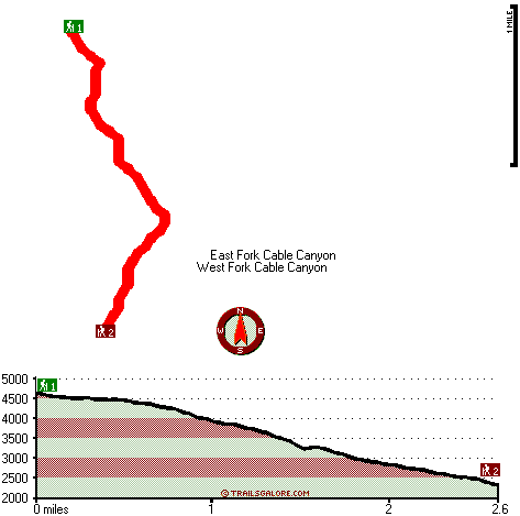
California hiking trails - Cable Canyon Trail, San Bernardino Mountains, San Bernardino County

   
  Backpacking in California is something that is always fun to do. Each one of the many hiking trails of California has its own unique prettiness. California has so much to offer the wilderness lovers. Hiking trails like this one here in the San Bernardino Mountains are a very good way to see these mountaintops. Cable Canyon Trail has two trailheads which means you have the option of hiking it one way if you have someone to pick you up at the other end. Magnificent hiking trails in California are in abundance; Cable Canyon Trail is one of them, and it's in
    San Bernardino County. This great outdoors trail is not that long but it's always fine to bring some emergency supplies, you never know what could happen. The total elevation difference for this wilderness hiking trail is 2,828 feet, and that is higher than average. This great
outdoors trail sometimes gets very dry, so do check for current fire restrictions before you go if you plan to bring a stove or make a camp fire. The number of hiking and backpacking trails in this neighborhood is not very high. Cable Canyon Trail is a wilderness hiking trail relatively far from Riverside-San Bernardino-Ontario, but backcountry backpacking it is wonderful pleasure any time. Please follow all local rules about fires and camping. During the days of summer highs here at Cable Canyon Trail reach the 90's. Once the sun is down it dips down to the 60's.  
The winter comes with highs in the 60's with temperatures at Cable Canyon Trail dipping down into the 40's through winter nights. Finally, backcountry backpacking time is here again, and Cable Canyon Trail in San Bernardino County, California is the great outdoors at its best. Some parts of Cable Canyon Trail are much higher up than other parts of the backcountry hiking trail, so keep in mind that you may need to dress differently at different elevations. You should count on this hike taking about 4.5 hours, but you never know stuff could go wrong and you could get stuck so be prepared for that. Cable Canyon Trail is 5.2 miles long it's a mid length backcountry walk. Cable Canyon Trail is a fine place of typical rainfall; the month of February is the wettest with most of the rain, and June is the month with the least moisture. The length of Cable Canyon Trail is about average having an average number of uphill miles which makes it a perfect hiking and backpacking trail for the average person looking for a perfect adventure.

Briefly about the general area:
A pleasant journey to Pine Flat is a splendid way to spend an afternoon, and a nice location to camp here at Cable Canyon Trail is San Bernadino Koa Kampground. These mountains rock, just explore all the fun things to do in the San Bernardino Mountains. The beauty of mother nature reveals herself at Middleman Falls, and nearby you locate West Fork Cable Canyon which is a good spot to stop by.
A journey to Cable Canyon Trail wouldn't be complete without taking a look at Sugarpine Spring; why not camp at Rio Baranca Valle Campground since you're here at Cable Canyon Trail.

Location of Trailhead 1: Latitude 34.253, Longitude -117.3822
- - Directions and Road Map

Location of Trailhead 2: Latitude 34.2258, Longitude -117.3793
- - Directions and Road Map


Trailhead 1 to Trailhead 2:
Total hiking length = 2.6 miles
Total climbing distance = .1 miles
Difficulty : Easy
Casual Hiking Pace: 1.5 hours
Fast Hiking Pace: 1 hours

Trailhead 2 to Trailhead 1:
Total hiking length = 2.6 miles
Total climbing distance = 2.1 miles
Difficulty : Difficult
Casual Hiking Pace: 3 hours
Fast Hiking Pace: 1.5 hours
    Trailhead 1 back to Trailhead 1:
Total hiking length = 5.2 miles
Total climbing distance = 2.2 miles
Difficulty : Medium
Casual Hiking Pace: 4.5 hours
Fast Hiking Pace: 3 hours

Trailhead 2 back to Trailhead 2:
Total hiking length = 5.2 miles
Total climbing distance = 2.2 miles
Difficulty : Medium
Casual Hiking Pace: 4.5 hours
Fast Hiking Pace: 3 hours

Total elevation difference: 2828 feet


Days Inn San Bernardino-University Parkway, San Bernardino
6 miles away
Welcome to Days Inn San Bernardino *We are conveniently located off Interstate 215 * The Blast Soccer Field is only 1 Mile away * CS ...
  
Best Western Cajon Pass, Phelan
8 miles away
Pool and Spa are temporarily out of service. Stay at this Phelan hotel located at the base of the scenic San Bernardino Mountains and enjoy a peaceful, serene visit in California. The Best Western...
User input for Cable Canyon Trail, San Bernardino Mountains, San Bernardino County, California:

Submit Input:
Your Name:
Write or Paste Input here:

Upload picture:      Review Guidelines


Outdoors Recreation Near Riverside-San Bernardino-Ontario, California
Very comprehensive list of a variety of outdoors recreation in the vicinity of Riverside-San Bernardino-Ontario, California, the metro area neareast to Cable Canyon Trail. Find info on campgrounds, hiking trails, ski resorts, lakes, beaches, parks, whitewater and more.

Current weather conditions at Cable Canyon Trail, San Bernardino Mountains, San Bernardino County, California
WXPort

Local climate location: FONTANA KAISER 12 miles away

Americas Best Value Inn & Suites, Rialto
8 miles away
The Americas Best Value Inn of Rialto, California offers every guest the perfect blend of value, superior service, and convenient location. Centrally located between Ontario and San Bernardino, in the...

The Wigwam Motel, Rialto
8 miles away
The Wigwam Motel features 19, 30-foot-tall tepees situated in a village like arrangement centered around grounds that include an outdoor barbecue grill and kidney-shaped swimming pool. Each tepee is a...

More Hotels and Campgrounds Near Cable Canyon Trail, San Bernardino Mountains, San Bernardino County, California

OTHER_INFO
  San Bernardino Mountains Campgrounds
Complete list of all the campgrounds in the San Bernardino Mountains.

San Bernardino Mountains Outdoors Info
Complete outdoors info for the San Bernardino Mountains.

California Hiking Trails
Complete list of all hiking trails in California

Books about hiking trails in California
List of books available on Amazon.com about hiking trails in California.

California Outdoors Index
This is a very comprehensive index of outdoors activities in the great state of California.


TOPO
High quality water resistant topo map of Cable Canyon Trail, San Bernardino Mountains, San Bernardino County, California.

OUTDOORS_GUIDE
These outdoors activities are available near Cable Canyon Trail.
 Trails Near Cable Canyon Trail:
Miller Canyon Trail, San Bernardino County , 8 miles away, 3.2 hiking miles, 1329 feet elevation difference
Cucamonga Peak Trail, San Bernardino County , 13 miles away,  10.4 hiking miles, 3105 feet elevation difference
McKinley Firebreak, San Bernardino County , 14 miles away,  3.4 hiking miles, 2228 feet elevation difference
 Camp Grounds Near Cable Canyon Trail:
San Bernadino Koa Kampground, San Bernardino, 2 miles away
Rio Baranca Valle Campground, San Bernardino County, 3 miles away
Mesa Campground, San Bernardino County, 3 miles away
Cajon Campground, San Bernardino County, 5 miles away
Camp Seely La City Recreation, Crestline, 5 miles away
 National Parks Near Cable Canyon Trail:
Mojave National Preserve, Barstow - CA , 44 miles away
 Hotels Near Cable Canyon Trail:
Days Inn San Bernardino-University Parkway, San Bernardino , 6 miles away
Best Western Cajon Pass, Phelan , 8 miles away
Americas Best Value Inn & Suites, Rialto , 8 miles away
The Wigwam Motel, Rialto , 8 miles away
Country Inn San Bernardino, San Bernardino , 9 miles away

Outdoors related information copyright © Stratus-Pikpuk, Inc. - Detailed hotel information copyright © Interactive Hotel Solutions