| |
|
| | California has plenty of great backpacking trails, and one of these is Buttermilk Trail in Tehama County. A lengthy drive divides Clearlake from Buttermilk Trail, but hiking it is always exciting. California has lots of outdoors pastimes. There are not too many hiking and backpacking trails in this vicinity. This backcountry hiking trail has two trailheads, so if you can get a ride from someone, you can backcountry walk it just one way. With its 2.4 miles of walking distance it's a short backpacking trail. When you're here in California backcountry trekking |
|
along one of its backpacking trails is the great thing to do. Buttermilk Trail stays roughly within the same elevation zone the whole time, so you won’t have to worry about different climate zones along your trek. Buttermilk Trail sees pretty high levels of rain; January is the
| | wettest month with most rain; July is when it's the driest. The warmest time of the year brings highs in the 90's to Buttermilk Trail. When the night sets in temperatures dip down into the 50's. The wintertime brings highs down to the 50's while Buttermilk Trail night low temperatures during the wintertime are in the 30's. At parts of the year this vicinity sees very little rain, so do check for current fire restrictions before you go if you plan to bring a stove or make a camp fire. Don’t forget to check for any current restrictions or closures before you go. | |
|
The pretty trails of the Klamath Mountains are the best way to enjoy these mountains. The total elevation difference for Buttermilk Trail is 1,097 feet which is about average. Even though this is not a very long backcountry trail you should still bring some emergency supplies just
in case something happens. Buttermilk Trail is a very short trail having an average number of uphill miles which makes it a nice hiking and backpacking trail for the average person looking for a nice adventure. Time to get out, and breathe some fresh air, and Buttermilk Trail in
Tehama County, California is a splendid place for getting out. Every single California backpacking trail has its own character. The time needed for this backcountry walk is roughly 2 hours, but you never know stuff could go wrong and you could get stuck so be prepared for that.
Briefly
about the general area: There's no way someone can get bored here in the Klamath Mountains. Some nearby water includes Panther Creek. You'll need more than a day to explore everything Buttermilk Trail has to offer, you can camp at Telephone Campground. Buttermilk Spring is
a delightful place to check out while you're at Buttermilk Trail; you can stay the night at Sugar Spring Campground. Board Creek is one of the streams nearby that might be worth going to, and Blackjack Spring is a great local attraction.
|
|
Location of Trailhead 1: Latitude 39.8161, Longitude -122.881 - - Directions and Road Map
Location of Trailhead 2: Latitude 39.8248, Longitude -122.8697 - - Directions and Road Map

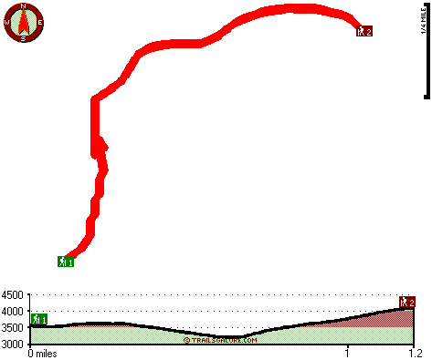
Trailhead 1 to Trailhead 2: Total hiking length = 1.2 miles Total climbing distance = .6 miles Difficulty : Medium Casual Hiking Pace:
1 hours
Fast Hiking Pace:
.5 hours
Trailhead 2 to Trailhead 1: Total hiking length = 1.2 miles Total climbing distance = .4 miles Difficulty : Medium Casual Hiking Pace:
1 hours
Fast Hiking Pace:
.5 hours
| | Trailhead 1 back to Trailhead 1: Total hiking length = 2.4 miles Total climbing distance = 1 miles Difficulty : Medium Casual Hiking Pace:
2 hours
Fast Hiking Pace:
1.5 hours
Trailhead 2 back to Trailhead 2: Total hiking length = 2.4 miles Total climbing distance = 1 miles Difficulty : Medium Casual Hiking Pace:
2 hours
Fast Hiking Pace:
1.5 hours
|
Total elevation difference: 1097 feet

Super 8 Motel - Upper Lake, Upper Lake
|
35 miles away
Pride of Super 8. AAA approved. We offer: complimentary SuperStart breakfast, wireless high speed internet, outdoor (seasonal) pool and whirlpool. Suites with microfridge and whirlpool available. We a...
|
| |
Lakeview Inn, Lucerne
|
39 miles away
Welcome to the newly remodeled Lakeview Inn A quaint and beautifully decorated Inn, with full amenities for the comfort of our guests. Group rates Available....
|
|
User input for Buttermilk Trail, Klamath Mountains, Tehama County, California:

Outdoors Recreation Near Clearlake, California Very comprehensive list of a variety of outdoors recreation in the vicinity of Clearlake, California, the metro area neareast to Buttermilk Trail. Find info on campgrounds, hiking trails, ski resorts, lakes, beaches, parks, whitewater and more.
More Hotels and Campgrounds Near Buttermilk Trail, Klamath Mountains, Tehama County, California
| |
|
| These outdoors activities are available near Buttermilk Trail. |
| | Trails Near Buttermilk Trail:
 |
Smoke Howe Trail, Trinity
County
, 11 miles away, 7.8 hiking miles, 1983 feet elevation difference |
 |
French Trail, Mendocino
County
, 11 miles away, 6 hiking miles, 1080 feet elevation difference |
|
| | Hotels Near Buttermilk Trail:
 |
Super 8 Motel - Upper Lake, Upper Lake
, 35 miles away |
 |
Lakeview Inn, Lucerne
, 39 miles away |
 |
Super 8 Willits, Willits
, 39 miles away |
 |
Lark Motel, Willits
, 39 miles away |
 |
Best Western Willits Inn, Willits
, 40 miles away |
|
|
|
 |
|