| |
|
| | Bunchgrass Trail is a long journey away from Red Bluff, but backcountry hiking is such an exciting thing to do, and this is a fine place to do that. When you're here in California trekking along one of its trails is a great way to spend some time. California has plenty of good trails; one of them being Bunchgrass Trail in Shasta County. This hiking and backpacking trail sometimes gets very dry, so do check for current fire restrictions before you go if you plan to bring a stove or make a camp fire. The number of wilderness hiking trails in this area |
|
is not very high. Every single California trail is well worth a backcountry hike. Bunchgrass Trail is a reasonably wet site regularly with a lot of rainfall; through the month of January you get the most snow around here; July meanwhile is the driest month. This backcountry trail
| | goes through some very different elevations which of course means you need to be prepared for different conditions on different parts of the backcountry trail. These backcountry hiking trails here in the Southern Cascade Range are a really pleasant way to spend quality time in the outdoors. This hike should take you about 2 days, so make sure you've got all your overnight gear packed. This backcountry hiking trail is a very long backcountry hiking trail with an average amount of climbing distance which makes this wilderness hiking trail great for hard | |
|
core backpackers looking for adventure. We all need to get out in the fresh air once in a while, and Bunchgrass Trail in Shasta County, California is a fine place to go. California is a brilliant location for trekkers. This hiking and backpacking trail has a total elevation difference
of 1,779 feet which is an average number. This hiking and backpacking trail has two trailheads which means you have the option of backcountry backpacking it one way if you have someone to pick you up at the other end. Now this hiking and backpacking trail is pretty long, so do
pack enough food to last the whole trip. Bunchgrass Trail is 12.8 miles long; it's a long backcountry trail. Don’t forget to check for any current restrictions or closures before you go. Summertime highs at Bunchgrass Trail commonly tend to be in the 80's while night lows are regularly
in the 40's. Daytime highs during the winter are in the 40's with temperatures at Bunchgrass Trail dipping down into the 10's during winter nights.
Briefly about the general area: All the outdoors fun things in the Southern Cascade Range will keep you coming back over
and over. A short journey to Cornaz Spring is always worthwhile, and hey, Bunchgrass Creek is a fine local stream. If you came for an overnight stay Bunchgrass Campground is a brilliant place to camp, and everybody loves Thousand Lakes Valley. What a location this is for outdoors
people. Cypress Campground is a perfect campground nearby, and Lassen Volcanic National Park is a good place close by. Yeah, come up here to the Southern Cascade Range for a good time. A great site in the neighborhood of Bunchgrass Trail is Bunchgrass Valley. Cornez Spring is a
lovely spot to go to while you're at Bunchgrass Trail, and Ashpan Flat is right here at Bunchgrass Trail. If you come at the right time of year, Pit River offers some splendid whitewater; swing by Honn Creek it's a brilliant place to check out.
|
|
Location of Trailhead 1: Latitude 40.6369, Longitude -121.5813 - - Directions and Road Map
Location of Trailhead 2: Latitude 40.7177, Longitude -121.5745 - - Directions and Road Map

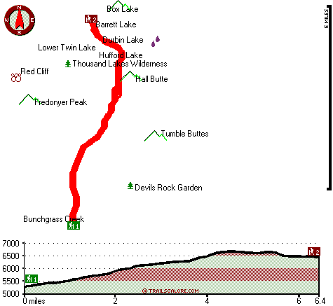
Trailhead 1 to Trailhead 2: Total hiking length = 6.4 miles Total climbing distance = 4.4 miles Difficulty : Difficult Casual Hiking Pace:
6.5 hours
Fast Hiking Pace:
4 hours
Trailhead 2 to Trailhead 1: Total hiking length = 6.4 miles Total climbing distance = 1 miles Difficulty : Difficult Casual Hiking Pace:
4.5 hours
Fast Hiking Pace:
2.5 hours
| | Trailhead 1 back to Trailhead 1: Total hiking length = 12.8 miles Total climbing distance = 5.4 miles Difficulty : Difficult Casual Hiking Pace:
2 days
Fast Hiking Pace:
7.5 hours
Trailhead 2 back to Trailhead 2: Total hiking length = 12.8 miles Total climbing distance = 5.4 miles Difficulty : Difficult Casual Hiking Pace:
2 days
Fast Hiking Pace:
7.5 hours
|
Total elevation difference: 1779 feet

Bailey Creek Cottages, Chester
|
29 miles away
Bailey Creek Cottages are located on the Public 18-Hole Bailey Creek Golf Course on the peninsula of Lake Almanor near Chester, California. Stay and play packages are available all through the golf se...
|
| |
Best Western Rose Quartz Inn, Chester
|
30 miles away
This Chester, California hotel is the perfect mountain get-away, offering a variety of amenities including an outdoor spa, recreation area, complimentary deluxe continental breakfast each morning. N...
|
|
User input for Bunchgrass Trail, Southern Cascade Range, Shasta County, California:

Outdoors Recreation Near Red Bluff, California Very comprehensive list of a variety of outdoors recreation in the vicinity of Red Bluff, California, the metro area neareast to Bunchgrass Trail. Find info on campgrounds, hiking trails, ski resorts, lakes, beaches, parks, whitewater and more.
|
Current weather conditions at Bunchgrass Trail, Southern Cascade Range, Shasta County, California

Local climate location: BURNEY 14 miles away

           
| |
Comfort Inn Central, Paradise
|
49 miles away
Quite country location, beautifully appointed guest rooms, excellent customer service, award winning hotel. Easy commute to Chico and Ca State University. Numerous local antique shops, Plenty of activ...
|
Paradise Inn, Paradise
|
49 miles away
Welcome to the Paradise Inn. Nestled amongst the beautiful tall pines you will discover one of the oldest, and most desirable places for lodging in the quaint little town of Paradise, Ca. As you enter...
|
|
More Hotels and Campgrounds Near Bunchgrass Trail, Southern Cascade Range, Shasta County, California
| |
|
| These outdoors activities are available near Bunchgrass Trail. |
| | Whitewater Near Bunchgrass Trail:
 |
Pit River, Shasta County
County
, 17 miles away, Class IV-V - 10 miles long (Fall River Mills Bridge to Route 299 Bridge) |
 |
Pit River, Shasta County
County
, 20 miles away, Class III-IV - 6 miles long (Lake Britton to Pit 3 Powerhouse) |
 |
Pit River, Shasta County
County
, 23 miles away, Class IV - 7 miles long (Pit 4 Dam to Pit 4 Powerhouse) |
 |
Battle Creek - South Fork, Tehama County
County
, 27 miles away, Class II-V(V+) - 11.5 miles long (Close to Ponderosa Way to Manton Road) |
|
| | Hotels Near Bunchgrass Trail:
 |
Bailey Creek Cottages, Chester
, 29 miles away |
 |
Best Western Rose Quartz Inn, Chester
, 30 miles away |
 |
Comfort Inn Central, Paradise
, 49 miles away |
 |
Paradise Inn, Paradise
, 49 miles away |
|
|
|
 |
|