| |
|
| | Here in California hiking is something that is always fun to do. Buena Vista Trail is not very next to Madera at all, but it's one of those sites where hiking is brilliant. A visit to California is not complete without some trekking. Buena Vista Trail gets a lot of water; of all the months in a year January is the one with the most rain, and July on the other hand is the driest. And keep in mind that there could be temporary safety restrictions in site. Keep in mind that this is a long backpacking trail, so don't forget to pack enough supplies. With its |
|
22.4 miles of walking distance; it's considered a longer trek. This neighborhood does get very dry sometimes, so make sure you check current conditions and fire restrictions with local forest authorities before you head out. The total elevation difference for this great outdoors
| | hiking trail is 2,797 feet which is a higher than average number. Alright, enough of spending all this time inside a building, time to get out, and if you happen to be in Madera County of California, Buena Vista Trail is an excellent local hiking trail for doing a bit of leg stretching. Backcountry trekking here in the Central Sierra Nevada is a very glorious way to see these mountains. Now, this is roughly a 3.5-day trek, so better have big backpack to fit all the stuff you need. There are so many wilderness hiking trails in this area. There are wilderness hiking | |
|
trails all over California, and Buena Vista Trail in Madera County is one of them. This great outdoors hiking trail has only one trailhead, so you'll be backpacking it in and back out. Different parts of Buena Vista Trail are at very different elevations, and that means that some
parts of the great outdoors trail could be very different from other parts of it. Throughout the warm months at Buena Vista Trail temperatures are usually in the 80's. Once the sun is down it sinks down to the 50's. The wintertime brings highs down to the 40's while Buena Vista
Trail night low temperatures all through the wintertime are in the 20's. The length of Buena Vista Trail is on the longer side with an average amount of climbing distance which makes it an outstanding wilderness hiking trail for experienced walkers in delightful shape. There are
plenty of wilderness hiking trails in California; each one of them is different from the others.
Briefly about the general area: Having a pleasant time in the Central Sierra Nevada is painless. Places like Stoneman Meadow are fine to explore; Buena Vista Trail is perfect
enough to spend more than a day at, Upper Pines Campground is a perfect local campground. Illilouette Gorge is a good place to spend some time at, and Pothole Meadows is a delightful location any time of year. A tour to Staircase Falls will fill your soul with perfect feelings;
some of the water nearby flows, like Tenaya Creek. You feel that's sufficient? Just getting warmed up. Looking for a tremendous trip? Yosemite National Park is relatively next to Buena Vista Trail, and don't leave Buena Vista Trail without first paying a visit to Illilouette Falls.
A tremendous place to camp here at Buena Vista Trail is Lower Pines Campground; paddling on Yosemite Creek is so much fun. You just can't imagine the amount of outdoors amusing things the Central Sierra Nevada has to offer. Getting to Illilouette Creek from Buena Vista Trail is painless, and get dripping wet paddling on Tenaya Creek.
|
|
Location of Trailhead: Latitude 37.6745, Longitude -119.5844 - - Directions and Road Map
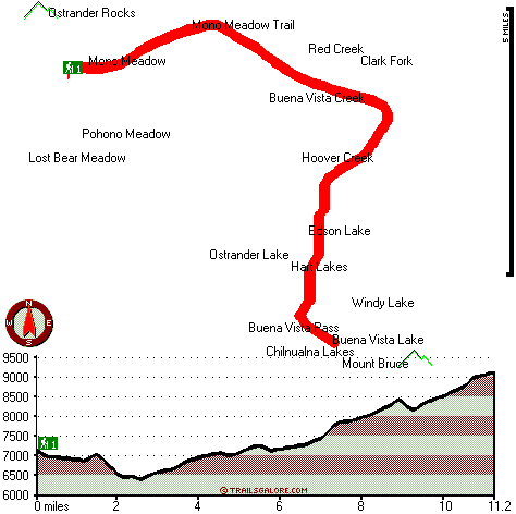
Total in and out hiking length = 22.4 miles
Total climbing distance = 10.3 miles
Difficulty : Difficult
Casual Hiking Pace:
3.5 days
Fast Hiking Pace:
2 days
Total elevation difference: 2797 feet

The Ahwahnee, Yosemite National Park
|
2 miles away
As a National Historical Landmark and one of the most distinctive resort hotels in North America, The Ahwahnee is well known for its great granite facade, striking beamed ceilings, massive stone heart...
|
| |
dnc -- Wawona Hotel, Yosemite National Park
|
5 miles away
Wawona is one of the oldest mountain resort hotels in California and a National Historic Landmark. Its verdant meadows, rushing streams, and tranquility make this a favorite of those who prefer a rela...
|
|
User input for Buena Vista Trail, Central Sierra Nevada, Madera County, California:

Outdoors Recreation Near Madera, California Very comprehensive list of a variety of outdoors recreation in the vicinity of Madera, California, the metro area neareast to Buena Vista Trail. Find info on campgrounds, hiking trails, ski resorts, lakes, beaches, parks, whitewater and more.
More Hotels and Campgrounds Near Buena Vista Trail, Central Sierra Nevada, Madera County, California
| |
| |
 |
|
| These outdoors activities are available near Buena Vista Trail. |
| | Trails Near Buena Vista Trail:
 |
Panorama Trail, Mariposa
County
, 0 miles away, 7.1 hiking miles, 3896 feet elevation difference |
 |
Mono Meadow Trail, Mariposa
County
, 2 miles away, 5.2 hiking miles, 1019 feet elevation difference |
 |
Mist Trail, Mariposa
County
, 2 miles away, 2.8 hiking miles, 1214 feet elevation difference |
 |
Four Mile Trail, Mariposa
County
, 2 miles away, 3.7 hiking miles, 3869 feet elevation difference |
 |
North Dome Trail, Mariposa
County
, 3 miles away, 14.4 hiking miles, 4985 feet elevation difference |
 |
Yosemite Falls Trail, Mariposa
County
, 3 miles away, 9.4 hiking miles, 3958 feet elevation difference |
 |
Half Dome Trail, Mariposa
County
, 4 miles away, 11.6 hiking miles, 5142 feet elevation difference |
|
| | Whitewater Near Buena Vista Trail:
 |
Yosemite Creek, Mariposa County
County
, 5 miles away, Class IV-V - 8 miles long (Tioga Pass Road to Yosemite Falls) |
 |
Tenaya Creek, Mariposa County
County
, 7 miles away, Class V - 1 miles long (Super Slide) |
 |
Merced River, Mariposa County
County
, 9 miles away, Class V - 4.8 miles long (Routes 120-140 Junction to Arch Rock Entrance Station) |
 |
Merced River - South Fork, Mariposa County
County
, 9 miles away, Class V+ - 16 miles long (Upper) |
 |
Tuolumne River, Tuolumne County
County
, 11 miles away, Class IV-V+ - 32 miles long (Tioga Road Bridge to Hetch Hetchy Reservoir) |
|
| | Hotels Near Buena Vista Trail:
 |
The Ahwahnee, Yosemite National Park
, 2 miles away |
 |
dnc -- Wawona Hotel, Yosemite National Park
, 5 miles away |
 |
Yosemite Lodge at the Falls, Yosemite National Park
, 5 miles away |
 |
dnc -- Housekeeping Camp, Yosemite National Park
, 5 miles away |
 |
Ahwahnee Hotel, Yosemite National Park
, 5 miles away |
|
|
|
 |
|