| |
Boundary National Recreation Trail has a total elevation difference of 4,828 feet, and that is higher than average. Different parts of Boundary National Recreation Trail are at very different elevations which of course means you need to be prepared for different conditions on different parts of the trail. Keep in mind that this is a long great outdoors hiking trail, so make sure you bring plenty of supplies. This area does get very dry sometimes, so make sure you check current conditions and fire restrictions with local forest authorities before you head out. Of course, this is an overnight hike, 5 days normally, so make sure you've got all your overnight gear packed. With its 33.2 miles of walking distance; it's considered a longer backcountry hike. There is only one trailhead, so you're looking at an in and out hike.
|
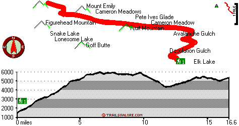
Total in and out hiking length = 33.2 miles
Total climbing distance = 15.5 miles
Difficulty : Difficult
Casual Hiking Pace:
5 days
Fast Hiking Pace:
3.5 days
Total elevation difference: 4828 feet
|


