| |
|
| | Each backpacking trail in California is striking in its own way. Hitting the backcountry trails is always an enjoyable thing to do, and Black Mountain Trail in Riverside County, California is a brilliant selection. If you are in California during hiking season you have to go hiking. Different parts of this wilderness hiking trail are at very different elevations, so keep in mind that you may need to dress differently at different elevations. Now this wilderness hiking trail is pretty long, so do pack enough food to last the whole trip. Black Mountain Trail |
|
has two trailheads which means you have the option of backpacking it one way if you have someone to pick you up at the other end. It is very dried up here at Black Mountain Trail ordinarily; during the month of December you get the most rain around here, and the driest of the months
| | is June. Sometimes this wilderness hiking trail gets really dry, so make sure you check current conditions and fire restrictions with local forest authorities before you head out. All through the summer at Black Mountain Trail temperatures are mostly in the 100's. All through the dark hours of summer temperatures plunge down into the 70's. The cold days of the wintertime come with highs in the 70's; after the sun is down throughout the wintertime temperatures at Black Mountain Trail plunge into the 40's. The total elevation difference for this backpacking | |
|
trail is 2,713 feet which is a higher than average number. Here in California backpacking is so much fun. The scenic hiking trails of the Santa Rosa Mountains are a very glorious way to see these hills. This hiking trail is a normal length hiking trail with an average amount of
climbing distance which makes it a nice backcountry hiking trail for experienced backcountry hikers in good shape. Rather far from Riverside-San Bernardino-Ontario you locate Black Mountain Trail, but backcountry hiking is such an enjoyable thing to do, and this is a brilliant
site to do that. There are so many backcountry hiking trails in this vicinity. California has plenty of splendid backpacking trails, and Black Mountain Trail in Riverside County is one of them. You should count on this backcountry hike taking about 5.5 hours, but of course some
folks walk a bit slower and some a bit faster. And keep in mind that there could be temporary safety restrictions in location. Being 6.4 miles long it's an average length wilderness hiking trail.
Briefly about the general area: Bay Tree Spring is a charming place to
take a look at while you're at Black Mountain Trail; Metate Flat is a great place here at Black Mountain Trail. Be careful coming to Black Mountain Trail, you might not ever want to return back home again. Hall Canyon is a nice site to look at, and you're sure to bump into some
great folks from Riverside-San Bernardino-Ontario here. A short visit to Cinco Poses Spring is always worthwhile, and you can stay the night at Halldecker Campground. Some of the water nearby flows, like Black Mountain Creek. You'll need more than a day to look at everything
Black Mountain Trail has to offer, you can camp at Fuller RIdge Campground. That right there is a load of amusing stuff already but it goes on, the Santa Rosa Mountains has it all. Be careful coming to the Santa Rosa Mountains, you might not ever wanna return home again. Azalea Creek is a perfect local stream, and a brilliant place like Hurley Flat here at Black Mountain Trail is too glorious to miss.
|
|
Location of Trailhead 1: Latitude 33.8275, Longitude -116.7958 - - Directions and Road Map
Location of Trailhead 2: Latitude 33.8263, Longitude -116.7595 - - Directions and Road Map

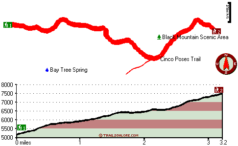
Trailhead 1 to Trailhead 2: Total hiking length = 3.2 miles Total climbing distance = 2.5 miles Difficulty : Difficult Casual Hiking Pace:
3.5 hours
Fast Hiking Pace:
2 hours
Trailhead 2 to Trailhead 1: Total hiking length = 3.2 miles Total climbing distance = .1 miles Difficulty : Easy Casual Hiking Pace:
2 hours
Fast Hiking Pace:
1 hours
| | Trailhead 1 back to Trailhead 1: Total hiking length = 6.4 miles Total climbing distance = 2.6 miles Difficulty : Difficult Casual Hiking Pace:
5.5 hours
Fast Hiking Pace:
3.5 hours
Trailhead 2 back to Trailhead 2: Total hiking length = 6.4 miles Total climbing distance = 2.6 miles Difficulty : Difficult Casual Hiking Pace:
5.5 hours
Fast Hiking Pace:
3.5 hours
|
Total elevation difference: 2713 feet

Morongo Casino Resort And Spa, Cabazon
|
6 miles away
---WELCOME TO MORONGO CASINO RESORT AND SPA---Unique, contemporary, nature-inspired design is a resonating theme throughout the new resort, the premier recreational gaming destination on the west coas...
|
| |
Cedar Street Inn and Spa, Idyllwild
|
7 miles away
Our Essence of Idyllwild award winning inn is unique in all of Idyllwild which has many more rustic lodges. If it is comfort and serenity that you are seeking, the Cedar Street Inn and Spa is the righ...
|
|
User input for Black Mountain Trail, Santa Rosa Mountains, Riverside County, California:

Outdoors Recreation Near Riverside-San Bernardino-Ontario, California Very comprehensive list of a variety of outdoors recreation in the vicinity of Riverside-San Bernardino-Ontario, California, the metro area neareast to Black Mountain Trail. Find info on campgrounds, hiking trails, ski resorts, lakes, beaches, parks, whitewater and more.
More Hotels and Campgrounds Near Black Mountain Trail, Santa Rosa Mountains, Riverside County, California
| |
| |
 |
|
| These outdoors activities are available near Black Mountain Trail. |
| | Trails Near Black Mountain Trail:
 |
Cinco Poses Trail, Riverside
County
, 1 miles away, 5.4 hiking miles, 2708 feet elevation difference |
 |
South Fork Trail, Riverside
County
, 8 miles away, 3.6 hiking miles, 1249 feet elevation difference |
 |
Rouse Hill-Bautista Canyon Trail, Riverside
County
, 9 miles away, 1.1 hiking miles, 1575 feet elevation difference |
 |
Kitching Peak Trail, Riverside
County
, 11 miles away, 6.8 hiking miles, 2299 feet elevation difference |
 |
East Branch Millard Canyon Trail, Riverside
County
, 11 miles away, 10 hiking miles, 3303 feet elevation difference |
 |
Pacific Crest Trail - section 4,
County
, 14 miles away, 55.3 hiking miles, 9055 feet elevation difference |
|
| | Hotels Near Black Mountain Trail:
 |
Morongo Casino Resort And Spa, Cabazon
, 6 miles away |
 |
Cedar Street Inn and Spa, Idyllwild
, 7 miles away |
 |
Idyllwild Inn, Idyllwild
, 7 miles away |
 |
Country Inn Banning, Banning
, 8 miles away |
 |
Super 8 Motel - Banning Casino/Outlet Mall, Banning
, 10 miles away |
|
|
|
 |
|