California hiking trails - Ben Arthur Trail, Coast Ranges, Trinity County

   
  There are hiking and backpacking trails all over California, and one of those is Ben Arthur Trail in Trinity County. As long as you like the wilderness you will like California. Can’t wait to get out in the outdoors, Ben Arthur Trail in Trinity County, California is a glorious place for getting out. Each hiking and backpacking trail in California is different from the others. The number of hiking trails in this area is not very high. And keep in mind that there could be temporary safety restrictions in place. With its 14.2 miles of walking distance;
    it's longer than many hiking trails. Ben Arthur Trail is a very long backcountry trail having an average number of uphill miles which makes it a nice hiking trail for experienced backcountry trekkers in brilliant shape. Quite far from Ukiah you discover Ben Arthur Trail, but it
sure is a a glorious wilderness hiking trail. All through the summer months highs here at Ben Arthur Trail get into the 80's while overnight lows are frequently in the 50's. The wintertime brings highs down to the 40's while the cold winter nights at Ben Arthur Trail are in the 30's. There are two trailheads to chose from, one in each end, so backpacking it one way is an option if you can arrange for a ride back. Ben Arthur Trail goes through some very different elevations, and that means that some parts of the hiking trail could be very different from  
other parts of it. This is a backpacking and hiking trail that is quite long, so make sure you bring plenty of supplies. Ben Arthur Trail sees pretty high levels of rain; December is when you get the most rain here, and July is when it's the driest. These backcountry trails here in the Coast Ranges are the best way to enjoy these hills. This backcountry hiking trail has a total elevation difference of 1,839 feet, and that is about average. Backpacking here in California is a wonderful way to spend some time. Sometimes this backpacking and hiking trail gets really dry, so do check for current fire restrictions before you go if you plan to bring a stove or make a camp fire. Now, this is roughly a 2-day backcountry trek, so it's a tremendous thing if your backpack is big enough to do the job.

Briefly about the general area:
And if that's not sufficient there's lots more entertaining stuff to do in the Coast Ranges. A visit to Surveyor Spring will fill your spirit with great feelings; whitewater paddling is not for everybody but if it's for you then, we recommend Eel River - North Fork.
There are some tremendous whitewater spots on Mad River; why not camp at Bailey Canyon Campground since you're here at Ben Arthur Trail. Just can't get enough of the Coast Ranges. Put some time aside to spend at Tub Spring since you're here at Ben Arthur Trail, and you have to certainly dedicate some time to Soldier Basin while you're here at Ben Arthur Trail. But wait, there's more to do near Ben Arthur Trail. Soldier Creek is a charming stream that is worth taking a look at, and camping is available at Fern Campground.
Hetten Cove is quite close to Ben Arthur Trail; don’t forget to explore Raglan Flat while you're here at Ben Arthur Trail. Don't forget to take a nice little visit to Gilman Creek, and close by Raglan Gulch is a splendid place to go.

Location of Trailhead 1: Latitude 40.2141, Longitude -123.3398
- - Directions and Road Map

Location of Trailhead 2: Latitude 40.2553, Longitude -123.4072
- - Directions and Road Map


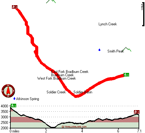
Trailhead 1 to Trailhead 2:
Total hiking length = 7.1 miles
Total climbing distance = 2.9 miles
Difficulty : Difficult
Casual Hiking Pace: 6 hours
Fast Hiking Pace: 3.5 hours

Trailhead 2 to Trailhead 1:
Total hiking length = 7.1 miles
Total climbing distance = 3.3 miles
Difficulty : Difficult
Casual Hiking Pace: 6.5 hours
Fast Hiking Pace: 3.5 hours
    Trailhead 1 back to Trailhead 1:
Total hiking length = 14.2 miles
Total climbing distance = 6.2 miles
Difficulty : Difficult
Casual Hiking Pace: 2 days
Fast Hiking Pace: 8.5 hours

Trailhead 2 back to Trailhead 2:
Total hiking length = 14.2 miles
Total climbing distance = 6.2 miles
Difficulty : Difficult
Casual Hiking Pace: 2 days
Fast Hiking Pace: 8.5 hours

Total elevation difference: 1839 feet


Best Western Humboldt House Inn, Garberville
31 miles away
Stay at this Garberville hotel situated at the entrance of the Humboldt Redwoods State Park. The Best Western Humboldt House Inn is conveniently located near Humboldt Redwoods State Park and hiking...
  
Motel Garberville, Garberville
31 miles away
Located just off HWY 101 in Garberville Ca in beautiful Humboldt County in the heart of Redwood Country. 8 miles South of Humboldt redwoods State Park. All of our clean attractive rooms have fridge m...
User input for Ben Arthur Trail, Coast Ranges, Trinity County, California:

Submit Input:
Your Name:
Write or Paste Input here:

Upload picture:      Review Guidelines


Outdoors Recreation Near Ukiah, California
Very comprehensive list of a variety of outdoors recreation in the vicinity of Ukiah, California, the metro area neareast to Ben Arthur Trail. Find info on campgrounds, hiking trails, ski resorts, lakes, beaches, parks, whitewater and more.

Current weather conditions at Ben Arthur Trail, Coast Ranges, Trinity County, California
WXPort

Local climate location: RICHARDSON GROVE ST PK 12 miles away

Dean Creek Resort, Redway
32 miles away
The award winning Dean Creek Resort is nestled on the banks of the Eel River in Giant Redwood country,only three miles from the world famous Avenue of the Giants in Humboldt State Forest. Open year ro...

Super 8 Willits, Willits
43 miles away
Welcome to Willits, CA, located in the heart of Mendocino County. Willits offers many activities in and around the community, and gives you firsthand experience of small town America at its finest. ...

More Hotels and Campgrounds Near Ben Arthur Trail, Coast Ranges, Trinity County, California

OTHER_INFO
  Coast Ranges Campgrounds
Complete list of all the campgrounds in the Coast Ranges.

Coast Ranges Outdoors Info
Complete outdoors info for the Coast Ranges.

California Hiking Trails
Complete list of all hiking trails in California

Books about hiking trails in California
List of books available on Amazon.com about hiking trails in California.

California Outdoors Index
This is a very comprehensive index of outdoors activities in the great state of California.


TOPO
High quality water resistant topo map of Ben Arthur Trail, Coast Ranges, Trinity County, California.

OUTDOORS_GUIDE
These outdoors activities are available near Ben Arthur Trail.
 Trails Near Ben Arthur Trail:
Ruth Hayfork Trail, Trinity County , 6 miles away, 6.6 hiking miles, 2939 feet elevation difference
Rough Gulch Trail, Trinity County , 8 miles away,  8 hiking miles, 4155 feet elevation difference
Ben Duncan Mailbox Trail, Trinity County , 8 miles away, 3.7 hiking miles, 1303 feet elevation difference
 Camp Grounds Near Ben Arthur Trail:
Fern Campground, Trinity County, 7 miles away
Bailey Canyon Campground, Trinity County, 8 miles away
Pickett Peak Campground, Trinity County, 8 miles away
Fir Cove Campground, Trinity County, 8 miles away
Forest Glen Campground, Trinity County, 9 miles away
 Whitewater Near Ben Arthur Trail:
Mad River, Trinity County County , 7 miles away, Class III - 5.8 miles long (North and South Fork confluence to Barry Creek Road)
Eel River - North Fork, Trinity/ Mendocino County County , 8 miles away, Class IV - 12 miles long (Salt Creek to Hulls Creek)
Trinity River - South Fork, Trinity County County , 10 miles away, Class IV-V - 8 miles long (Downstream from Forest Glen)
Van Duzen River, Trinity County County , 11 miles away, Class III - 7.2 miles long (West Fork to Senteney Creek)
Eel River - North Fork, Trinity/ Mendocino County County , 13 miles away, Class III - 8 miles long (Hulls Creek to Mina Road)
 National Parks Near Ben Arthur Trail:
Whiskeytown National Recreation Area, Whiskeytown - CA , 59 miles away
 Hotels Near Ben Arthur Trail:
Best Western Humboldt House Inn, Garberville , 31 miles away
Motel Garberville, Garberville , 31 miles away
Dean Creek Resort, Redway , 32 miles away
Super 8 Willits, Willits , 43 miles away
Lark Motel, Willits , 43 miles away

Outdoors related information copyright © Stratus-Pikpuk, Inc. - Detailed hotel information copyright © Interactive Hotel Solutions