California hiking trails - Belix Trail, Northern Sierra Nevada, Placer County

   
  Here in the pleasant state of California backcountry backpacking is a fine idea. Belix Trail is a long drive away from Truckee-Grass Valley, but it is a fine refuge from the urban center. With so many outdoors endeavors available in California you'll never get bored. Of course, this is an overnight backcountry hike, 2 days normally, so better have big backpack to fit all the stuff you need. The high level of precipitation makes Belix Trail a rather wet location; of all the months in a year January is the one with the most rain; the driest of the months
    is July. This is one of many hiking and backpacking trails in the surrounding region. There are backpacking and hiking trails all over California; among these are Belix Trail in Placer County. Each one of the many backpacking and hiking trails of California has its own character.
Put on your hiking shoes, and hit the hiking trail, Belix Trail in Placer County, California is a fine place to go. This great outdoors trail sometimes gets very dry, so do check for current fire restrictions before you go if you plan to bring a stove or make a camp fire. The total elevation difference for Belix Trail is 1,141 feet which is an average number. The great outdoors trail stays roughly within the same elevation zone the whole time, so you get pretty much the same conditions along the whole great outdoors trail. During the warm months at Belix  
Trail highs are commonly in the 90's. Summer overnight lows dip down to the 60's. For the period of the winter highs are usually in the 50's, and overnight lows through the winter for Belix Trail tend to be in the 30's. Being 13.8 miles long; it's considered a longer backcountry walk. Please follow all local rules about fires and camping. This is a great outdoors trail that is quite long, so do pack enough food to last the whole trip. The length of Belix Trail is on the longer side with an average amount of climbing distance which makes this hiking and backpacking trail great for hard core backpackers looking for adventure. Hiking and backpacking trails like this one here in the Northern Sierra Nevada are a very glorious way to see these summits. Belix Trail is a two ended wilderness hiking trail with two trailheads, so backcountry hiking it one way is an option if you can arrange for a ride back.

Briefly about the general area:
This place, Belix Trail, it just has so much outdoors cool stuff. A visit to Belix Trail wouldn't be complete without taking a look at Leonardi Spring; you can run the rapids of Rubicon River. Wildcat Meadow is right here at Belix Trail, and American River - South Fork is a good whitewater spot nearby.
And that's not all there is to do here in the Northern Sierra Nevada. The beauty of mother nature reveals herself at McCulloh Spring. A good spot like Blacksmith Flat here at Belix Trail is too perfect to miss, and swing by Plum Creek it's a delightful location to go to. So many enjoyable things in the Northern Sierra Nevada, just fantastic. There's so much to do here at Belix Trail that you need to camp here for a while, Big Tree Grove Campground is a good site for that; close by North Wallace Canyon is a wonderful spot to go.
You'll need more than a day to explore everything Belix Trail has to offer, you can camp at Vista Overflow Campground; do visit Honey Creek since you're here at Belix Trail.

Location of Trailhead 1: Latitude 38.9292, Longitude -120.5599
- - Directions and Road Map

Location of Trailhead 2: Latitude 38.9572, Longitude -120.4845
- - Directions and Road Map


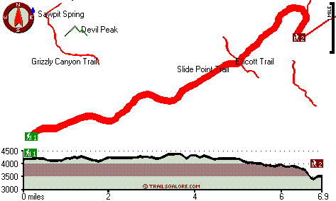
Trailhead 1 to Trailhead 2:
Total hiking length = 6.9 miles
Total climbing distance = 2.6 miles
Difficulty : Difficult
Casual Hiking Pace: 6 hours
Fast Hiking Pace: 3 hours

Trailhead 2 to Trailhead 1:
Total hiking length = 6.9 miles
Total climbing distance = 3.2 miles
Difficulty : Difficult
Casual Hiking Pace: 6.5 hours
Fast Hiking Pace: 3.5 hours
    Trailhead 1 back to Trailhead 1:
Total hiking length = 13.8 miles
Total climbing distance = 5.8 miles
Difficulty : Difficult
Casual Hiking Pace: 2 days
Fast Hiking Pace: 8 hours

Trailhead 2 back to Trailhead 2:
Total hiking length = 13.8 miles
Total climbing distance = 5.8 miles
Difficulty : Difficult
Casual Hiking Pace: 2 days
Fast Hiking Pace: 8 hours

Total elevation difference: 1141 feet


Best Western Stagecoach Inn, Pollock Pines
11 miles away
Amid tall pine trees of the high Sierra Mountains, Best Western Stagecoach Inn is located in the town of Pollock Pines, 'Nature's Wonderland', off of US 50 between Sacramento and South Lake Tahoe. Her...
  
Westhaven Inn Pollock Pines, Pollock Pines
12 miles away
Outside of Sacramento and situated on Highway 50, The Westhaven Inn offers convenience to shopping, golfing, hiking, boating, skiing, and other various outdoor activities. Only minutes to Sierra at T...
User input for Belix Trail, Northern Sierra Nevada, Placer County, California:

Submit Input:
Your Name:
Write or Paste Input here:

Upload picture:      Review Guidelines


Outdoors Recreation Near Truckee-Grass Valley, California
Very comprehensive list of a variety of outdoors recreation in the vicinity of Truckee-Grass Valley, California, the metro area neareast to Belix Trail. Find info on campgrounds, hiking trails, ski resorts, lakes, beaches, parks, whitewater and more.

Current weather conditions at Belix Trail, Northern Sierra Nevada, Placer County, California
WXPort

Local climate location: COLFAX 7 miles away

NATIONAL 9 INN, Placerville
21 miles away
National 9 Inn is a two story frame stucco building. All rooms have Direct Dial Phones and Color Cable TV with Free HBO. Complimentary Continental Breakfast is available in the office. Smoking and non...

Albert Shafsky House Bed And Breakfast, Placerville
21 miles away
1902 Queen Anne Victorian bed and breakfast in the Placerville Historic District provides a wonderful taste of rich heritage, both inside and out. We are a romantic, comfortable bed and breakfast in E...

More Hotels and Campgrounds Near Belix Trail, Northern Sierra Nevada, Placer County, California

OTHER_INFO
  Northern Sierra Nevada Campgrounds
Complete list of all the campgrounds in the Northern Sierra Nevada.

Northern Sierra Nevada Outdoors Info
Complete outdoors info for the Northern Sierra Nevada.

California Hiking Trails
Complete list of all hiking trails in California

Books about hiking trails in California
List of books available on Amazon.com about hiking trails in California.

California Outdoors Index
This is a very comprehensive index of outdoors activities in the great state of California.


TOPO
High quality water resistant topo map of Belix Trail, Northern Sierra Nevada, Placer County, California.

OUTDOORS_GUIDE
These outdoors activities are available near Belix Trail.
 Trails Near Belix Trail:
Slide Point Trail, Placer County , 2 miles away, 1.2 hiking miles, 1512 feet elevation difference
Ellicott Trail, El Dorado County , 3 miles away, 1.3 hiking miles, 1591 feet elevation difference
Grizzly Canyon Trail, Placer County , 3 miles away, 2 hiking miles, 381 feet elevation difference
Grey Trail, Placer County , 4 miles away, 2.4 hiking miles, 2339 feet elevation difference
Pigeon Roost Trail, Placer County , 5 miles away, 1.4 hiking miles, 763 feet elevation difference
South Fork Trail, El Dorado County , 6 miles away,  6.8 hiking miles, 1919 feet elevation difference
Hunsucker Trail, El Dorado County , 6 miles away, 1.9 hiking miles, 413 feet elevation difference
 Camp Grounds Near Belix Trail:
Vista Overflow Campground, El Dorado County, 6 miles away
Big Tree Grove Campground, Placer County, 7 miles away
Sunset Campground, El Dorado County, 9 miles away
Bridal Veil Campground, El Dorado County, 10 miles away
Yellow Jacket Campground, El Dorado County, 10 miles away
 Whitewater Near Belix Trail:
Rubicon River, Placer/ El Dorado County County , 5 miles away, Class V - 20.3 miles long (Ellicott Bridge to Ralston Afterbay)
American River - South Fork, El Dorado County County , 9 miles away, Class IV-V - 9.4 miles long (Peavine Ridge Road to Forebay Road)
American River - South Fork, El Dorado County County , 10 miles away, Class III-IV - 3.5 miles long (Riverton to Peavine Ridge Road)
American River - South Fork, El Dorado County County , 14 miles away, Class III-V - 9.6 miles long (Kyburz to Riverton)
American River - Middle Fork, Placer County County , 15 miles away, Class IV-V - 2.1 miles long (Mosquito Ridge Road to confluence with Middle Fork)
 Hotels Near Belix Trail:
Best Western Stagecoach Inn, Pollock Pines , 11 miles away
Westhaven Inn Pollock Pines, Pollock Pines , 12 miles away
NATIONAL 9 INN, Placerville , 21 miles away
Albert Shafsky House Bed And Breakfast, Placerville , 21 miles away
Historic Cary House Hotel, Placerville , 22 miles away
 Lakes Near Belix Trail
Jerrys Pool, Placer County , 2 miles away
Stumpy Meadows Reservoir, El Dorado County , 6 miles away

Outdoors related information copyright © Stratus-Pikpuk, Inc. - Detailed hotel information copyright © Interactive Hotel Solutions