California hiking trails - Bedbug Smith Trail, Northern Sierra Nevada, Sierra County

   
  Backcountry hiking in California never gets boring. Great outdoors hiking trails for backcountry hiking, and backpacking can be found all over California, and Bedbug Smith Trail in Sierra County is one of them. This part of California has a glorious deal of available outdoors activities. Bedbug Smith Trail is located a pretty long trip from Truckee-Grass Valley, but it is an amusing location to hike. Bedbug Smith Trail goes through some very different elevations, and that means that some parts of the great outdoors trail could be very different from
    other parts of it. Bedbug Smith Trail is quite long, so make sure you bring plenty of supplies. This is a vicinity covered with lots of backpacking trails. This vicinity does get very dry sometimes, so do check for current fire restrictions before you go if you plan to bring a
stove or make a camp fire. Bedbug Smith Trail is 6.2 miles long it's a mid length trek. Each wilderness hiking trail in California has its own character. Please follow all local rules about fires and camping. Bedbug Smith Trail has only one trailhead, so in and out is the way to walk it normally. The total elevation difference for this hiking trail is 1,927 feet which is an average number. This wilderness hiking trail is a mid length wilderness hiking trail having an average number of uphill miles which makes this a very tough backpacking trail for advanced  
hikers looking for a tremendous challenge. Hiking here in the Northern Sierra Nevada is a very pleasant way to see these mountains. Alright, enough of spending all this time inside a building, time to get out, and Bedbug Smith Trail in Sierra County, California is such a wonderful location. Through the summer months, highs usually are in the 90's at Bedbug Smith Trail. Once the sun is down it plunges down to the 40's. High temperatures all through the wintertime are normally in the 40's while Bedbug Smith Trail overnight low temperatures all through the wintertime are in the 20's. This trek shouldn't take more than 5.5 hours, but of course some people walk a bit slower and some a bit faster. Bedbug Smith Trail gets a normal amount of annual rainfall; January is the wettest month with most rain, and July is when it's the driest.

Briefly about the general area:
There are plenty of folks from Truckee-Grass Valley here at Bedbug Smith Trail, and Middlewaters Campground is a wonderful campground nearby. Cornish Flat is a great place; get your heart pumping on the good whitewater of Yuba River - North Fork.
So much exciting stuff to do here at Bedbug Smith Trail, too wonderful to be true. Since you're here at Bedbug Smith Trail why not check out Tehama Ravine; do stop at Bear Creek if you're here at Bedbug Smith Trail. You can run the rapids of Pauley Creek right next door to Bedbug Smith Trail, and naturally Rattlesnake Creek is a delightful stream that is worth a visit. All year is a great time in the Northern Sierra Nevada if you fancy the outdoors. Woolsey Flat is a good spot to check out, and Union Flat Campground is a magnificent local campground.
Life's too short to enjoy all the exciting stuff in the Northern Sierra Nevada.

Location of Trailhead: Latitude 39.4707, Longitude -120.7577
- - Directions and Road Map

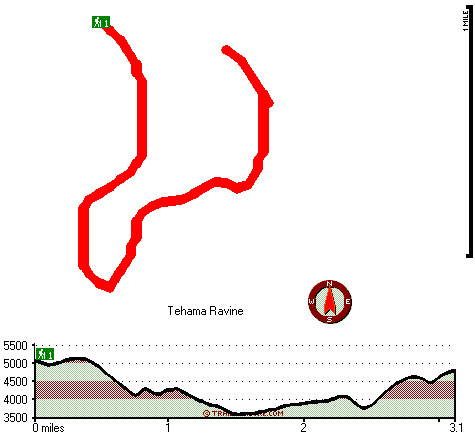
Total in and out hiking length = 6.2 miles

Total climbing distance = 2.8 miles

Difficulty : Difficult

Casual Hiking Pace: 5.5 hours

Fast Hiking Pace: 3.5 hours

Total elevation difference: 1927 feet


Deer Creek Inn, Nevada City
9 miles away
Deer Creek Inn is a 150 year old restored Queen Anne Victorian located in the historic Gold Rush town of Nevada City, California. The historic shopping and dining district on Broad Street is only foot...
  
Nevada City Inn, Nevada City
21 miles away
A home away from home! Comfortable, park-like setting, 2/3 of a mile to downtown Nevada City, 27 guest rooms inluding 7 cottages. We are now an all non smoking room hotel. We are a pet friendly hotel...
User input for Bedbug Smith Trail, Northern Sierra Nevada, Sierra County, California:

Submit Input:
Your Name:
Write or Paste Input here:

Upload picture:      Review Guidelines


Outdoors Recreation Near Truckee-Grass Valley, California
Very comprehensive list of a variety of outdoors recreation in the vicinity of Truckee-Grass Valley, California, the metro area neareast to Bedbug Smith Trail. Find info on campgrounds, hiking trails, ski resorts, lakes, beaches, parks, whitewater and more.

Current weather conditions at Bedbug Smith Trail, Northern Sierra Nevada, Sierra County, California
WXPort

Local climate location: QUINCY 13 miles away

Piety Hill Cottages, Nevada City
21 miles away
9 Tastefully appointed BnB cottages in this parklike setting 1 acre with tree-shaded grassy courtyard...

Chalet View Lodge, Graeagle
22 miles away

More Hotels and Campgrounds Near Bedbug Smith Trail, Northern Sierra Nevada, Sierra County, California

OTHER_INFO
  Northern Sierra Nevada Campgrounds
Complete list of all the campgrounds in the Northern Sierra Nevada.

Northern Sierra Nevada Outdoors Info
Complete outdoors info for the Northern Sierra Nevada.

California Hiking Trails
Complete list of all hiking trails in California

Books about hiking trails in California
List of books available on Amazon.com about hiking trails in California.

California Outdoors Index
This is a very comprehensive index of outdoors activities in the great state of California.


TOPO
High quality water resistant topo map of Bedbug Smith Trail, Northern Sierra Nevada, Sierra County, California.

OUTDOORS_GUIDE
These outdoors activities are available near Bedbug Smith Trail.
 Trails Near Bedbug Smith Trail:
Bayes Cabin Road, Nevada County , 2 miles away,  3.4 hiking miles, 1568 feet elevation difference
Canyon Creek Trail, Nevada County , 6 miles away, 4.9 hiking miles, 1929 feet elevation difference
Eagle Bird Trail, Nevada County , 7 miles away, 1.6 hiking miles, 1371 feet elevation difference
Second Divide Trail, Sierra County , 7 miles away,  7.2 hiking miles, 1442 feet elevation difference
Third Divide Trail, Sierra County , 8 miles away, 2.5 hiking miles, 2062 feet elevation difference
Butcher Ranch Trail, Sierra County , 9 miles away, 3 hiking miles, 2125 feet elevation difference
Bowman Mountain Trail, Nevada County , 9 miles away, 3.6 hiking miles, 1277 feet elevation difference
 Camp Grounds Near Bedbug Smith Trail:
Union Flat Campground, Sierra County, 6 miles away
Middlewaters Campground, Sierra County, 6 miles away
Pineaire Campground, Nevada County, 6 miles away
River Rest Resort, Washington, 6 miles away
Gene's Pineaire Campground, Washington, 6 miles away
 Whitewater Near Bedbug Smith Trail:
Yuba River - North Fork, Sierra County County , 6 miles away, Class IV-V - 13 miles long (Wild Plum Campground to Downieville)
Pauley Creek, Sierra County County , 7 miles away, Class III-IV - 4 miles long (Second Divide Turnout to Downieville)
Lavezzola Creek, Sierra County County , 7 miles away, Class IV(V) - 4 miles long (2nd Divide Bridge to Downieville)
Yuba River - North Fork, Sierra County County , 9 miles away, Class II-V - 4 miles long (Downieville to Goodyears Bar Bridge)
Yuba River - South Fork, Nevada County County , 11 miles away, Class IV - 14 miles long (Washington to Edwards Crossing)
 Hotels Near Bedbug Smith Trail:
Deer Creek Inn, Nevada City , 9 miles away
Nevada City Inn, Nevada City , 21 miles away
Piety Hill Cottages, Nevada City , 21 miles away
Chalet View Lodge, Graeagle , 22 miles away
Best Western Gold Country Inn, Grass Valley , 23 miles away

Outdoors related information copyright © Stratus-Pikpuk, Inc. - Detailed hotel information copyright © Interactive Hotel Solutions