| |
|
| | In California you never run out of outdoors fun. Going for a walk here in California is so much fun. Finally, hiking time is here again, and Bearcamp Flat Trail in Modoc County, California is a magnificent location to go. Summertime highs at Bearcamp Flat Trail commonly tend to be in the 80's. Summer night lows drop down to the 40's. For the period of the winter the highs are mostly in the 40's, and night lows at Bearcamp Flat Trail all through the winter mostly drop into the 10's. There's not much difference in elevation along the hiking and backpacking |
|
trail, so you won’t have to worry about different climate zones along your trek. California has plenty of delightful great outdoors trails, and Bearcamp Flat Trail is one of them, and it's in Modoc County. Please follow all local rules about fires and camping. This backcountry
| | trail has two trailheads which means you have the option of trekking it one way if you have someone to pick you up at the other end. This vicinity does get very dry sometimes, so do check for current fire restrictions before you go if you plan to bring a stove or make a camp fire. This great outdoors hiking trail is a very short great outdoors hiking trail having an average number of uphill miles which makes it a nice trail for the average person looking for a nice adventure. Far from civilization you discover Bearcamp Flat Trail, and It's always fun to | |
|
walk here. These great outdoors hiking trails here in the Warner Mountains are a great way to explore these summits. The total elevation difference for this backcountry trail is 527 feet which is lower than average. Each great outdoors trail in California has something unique to
offer. With its 2.2 miles of walking distance it's shorter than many hiking and backpacking trails. The time needed for this backcountry walk is roughly 2 hours, but you never know stuff could go wrong and you could get stuck so be prepared for that. This is one of many trails
in the surrounding area. This backcountry hiking trail is not that long but you should still bring some emergency supplies just in case something happens. At Bearcamp Flat Trail you don’t see much rainfall; November is when you get the most rain here, and July is the month with
the least moisture.
Briefly about the general area: This river has so much to offer. Man, is there a lot of amusing things to do in the Warner Mountains. South Fork Emerson Creek is a great place to stop by, and a delightful place to camp here at Bearcamp Flat Trail
is Blue Lake Campground. Some of the water close by flows, like North Fork Emerson Creek, and Bearcamp Flat Trail is magnificent enough to spend more than a day at, Soup Spring Campground is a magnificent local campground.
|
|
Location of Trailhead 1: Latitude 41.2464, Longitude -120.1493 - - Directions and Road Map
Location of Trailhead 2: Latitude 41.2364, Longitude -120.1453 - - Directions and Road Map

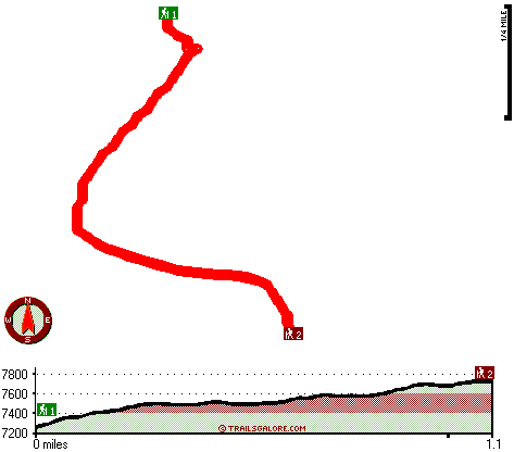
Trailhead 1 to Trailhead 2: Total hiking length = 1.1 miles Total climbing distance = .7 miles Difficulty : Medium Casual Hiking Pace:
1 hours
Fast Hiking Pace:
.5 hours
Trailhead 2 to Trailhead 1: Total hiking length = 1.1 miles Total climbing distance = .1 miles Difficulty : Easy Casual Hiking Pace:
.5 hours
Fast Hiking Pace:
.5 hours
| | Trailhead 1 back to Trailhead 1: Total hiking length = 2.2 miles Total climbing distance = .8 miles Difficulty : Medium Casual Hiking Pace:
2 hours
Fast Hiking Pace:
1 hours
Trailhead 2 back to Trailhead 2: Total hiking length = 2.2 miles Total climbing distance = .8 miles Difficulty : Medium Casual Hiking Pace:
2 hours
Fast Hiking Pace:
1 hours
|
Total elevation difference: 527 feet

Best Western Trailside Inn, Alturas
|
30 miles away
Here in Modoc county, surrounding the Best Western Trailside Inn in Alturas, is the history of the American west. From the days of discovery and exploration to the glory structures of another generat...
|
| |
Super 8 Motel - Alturas, Alturas
|
30 miles away
AAA approved/2 Diamonds. Superstart Breakfast, high speed wireless and wired internet access, microwaves/refrigerators, hairdryers, cable TV w/HBO, ESPN, suites available. Golf Course 1 mile, Ski Area...
|
|
User input for Bearcamp Flat Trail, Warner Mountains, Modoc County, California:

Outdoors Recreation Near Reno-Sparks, Nevada Very comprehensive list of a variety of outdoors recreation in the vicinity of Reno-Sparks, Nevada, the metro area neareast to Bearcamp Flat Trail. Find info on campgrounds, hiking trails, ski resorts, lakes, beaches, parks, whitewater and more.
More Hotels and Campgrounds Near Bearcamp Flat Trail, Warner Mountains, Modoc County, California
| |
|
| These outdoors activities are available near Bearcamp Flat Trail. |
| | Trails Near Bearcamp Flat Trail:
 |
Emerson Creek Trail, Modoc
County
, 2 miles away, 7 hiking miles, 2630 feet elevation difference |
 |
East Creek Trail, Modoc
County
, 4 miles away, 7.5 hiking miles, 2136 feet elevation difference |
 |
Poison Flat Trail, Modoc
County
, 6 miles away, 5.2 hiking miles, 1721 feet elevation difference |
 |
Pine Creek Trail, Modoc
County
, 9 miles away, 8.6 hiking miles, 2881 feet elevation difference |
 |
Owl Creek Trail, Modoc
County
, 9 miles away, 12.5 hiking miles, 4124 feet elevation difference |
|
|
|
 |
|