California hiking trails - Bayes Cabin Road, Northern Sierra Nevada, Nevada County

   
  Can’t wait to get out in nature, Bayes Cabin Road in Nevada County, California is a perfect place to go. This part of California is always a joy to visit during backcountry trekking season. Every single California backpacking and hiking trail is delightful in its own way. There are so many backcountry trails in this neighborhood. Bayes Cabin Road is 3.4 miles long it's shorter than many backcountry hiking trails. For the duration of the warm days of summer at Bayes Cabin Road highs are usually in the 90's; during summer nights temperatures are in the
    40's. The cold days of the winter come with highs in the 40's; winter nights come with lows in the 20's to Bayes Cabin Road. Great backpacking and hiking trails in California are in abundance; Bayes Cabin Road in Nevada County is one of them. And keep in mind that there could be
temporary safety restrictions in site. Bayes Cabin Road is a long journey away from Truckee-Grass Valley, but it is a really brilliant hiking trail. The total elevation difference for this hiking trail is 1,568 feet, and that is about average. The picturesque backpacking trails of the Northern Sierra Nevada are a very glorious way to see these mountaintops. Bayes Cabin Road gets a common amount of rain; the month of January is the wettest with most of the rain, and July is when it's the driest. When you're here in California hiking along one of its backpacking  
and hiking trails is so much fun. This hiking trail has only one trailhead, so you're looking at an in and out hike. This backpacking and hiking trail sometimes gets very dry, so do check for current fire restrictions before you go if you plan to bring a stove or make a camp fire. This is not a very long backpacking and hiking trail but you should still bring some emergency supplies just in case something happens. This backcountry walk shouldn't take more than 3 hours, but you never know stuff could go wrong and you could get stuck so be prepared for that. This backpacking trail is a very short backpacking trail with an average amount of climbing distance which makes it a wonderful backcountry trail for the average person looking for a wonderful adventure. Bayes Cabin Road goes through some very different elevations which of course means you need to be prepared for different conditions on different parts of the backcountry hiking trail.

Briefly about the general area:
Take a little trip to Little Wolf Creek since you're here at Bayes Cabin Road, and you might also want to pay a visit to National Gulch if you're here at Bayes Cabin Road. If you go for the outdoors you'll go for it here in the Northern Sierra Nevada. You can run the rapids of Yuba River - North Fork near Bayes Cabin Road, and you can stay the night at Pineaire Campground.
Bayes Cabin Road truly is in the middle of a stunning outdoors paradise. There's so much to do here at Bayes Cabin Road that you need to camp here for a while, River Rest Resort is a glorious site for that; don’t forget to pop by Woolsey Flat while you're here at Bayes Cabin Road. Pauley Creek is a good whitewater spot right next door to Bayes Cabin Road, and you're sure to stumble upon some cheerful folks from Truckee-Grass Valley here.

Location of Trailhead: Latitude 39.4287, Longitude -120.7706
- - Directions and Road Map

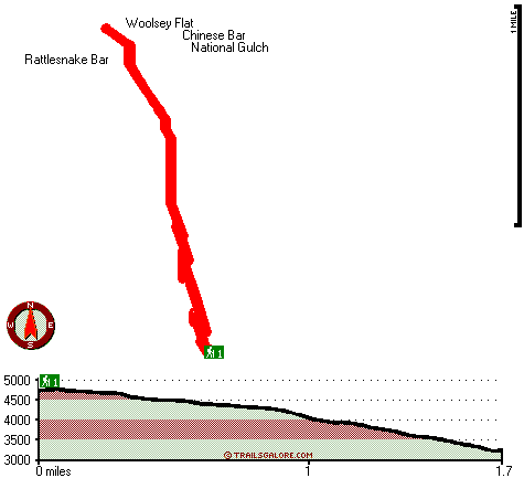
Total in and out hiking length = 3.4 miles

Total climbing distance = 1.5 miles

Difficulty : Medium

Casual Hiking Pace: 3 hours

Fast Hiking Pace: 2 hours

Total elevation difference: 1568 feet


Deer Creek Inn, Nevada City
7 miles away
Deer Creek Inn is a 150 year old restored Queen Anne Victorian located in the historic Gold Rush town of Nevada City, California. The historic shopping and dining district on Broad Street is only foot...
  
Nevada City Inn, Nevada City
19 miles away
A home away from home! Comfortable, park-like setting, in-town Nevada City, 27 guest rooms inluding 7 cottages. We are now an all non smoking room hotel. Outside smoking okay only....
User input for Bayes Cabin Road, Northern Sierra Nevada, Nevada County, California:

Submit Input:
Your Name:
Write or Paste Input here:

Upload picture:      Review Guidelines


Outdoors Recreation Near Truckee-Grass Valley, California
Very comprehensive list of a variety of outdoors recreation in the vicinity of Truckee-Grass Valley, California, the metro area neareast to Bayes Cabin Road. Find info on campgrounds, hiking trails, ski resorts, lakes, beaches, parks, whitewater and more.

Current weather conditions at Bayes Cabin Road, Northern Sierra Nevada, Nevada County, California
WXPort

Local climate location: QUINCY 15 miles away

Piety Hill Cottages, Nevada City
20 miles away
9 Tastefully appointed BnB cottages in this parklike setting 1 acre with tree-shaded grassy courtyard...

Best Western Gold Country Inn, Grass Valley
21 miles away
Stay at this Grass Valley hotel in the heart of California's Gold Country. The Best Western Gold Country Inn is nestled amongst the pines of the Sierra Foothills off Highway 49 in California. The hot...

More Hotels and Campgrounds Near Bayes Cabin Road, Northern Sierra Nevada, Nevada County, California

OTHER_INFO
  Northern Sierra Nevada Campgrounds
Complete list of all the campgrounds in the Northern Sierra Nevada.

Northern Sierra Nevada Outdoors Info
Complete outdoors info for the Northern Sierra Nevada.

California Hiking Trails
Complete list of all hiking trails in California

Books about hiking trails in California
List of books available on Amazon.com about hiking trails in California.

California Outdoors Index
This is a very comprehensive index of outdoors activities in the great state of California.


TOPO
High quality water resistant topo map of Bayes Cabin Road, Northern Sierra Nevada, Nevada County, California.

OUTDOORS_GUIDE
These outdoors activities are available near Bayes Cabin Road.
 Trails Near Bayes Cabin Road:
Bedbug Smith Trail, Sierra County , 2 miles away,  6.2 hiking miles, 1927 feet elevation difference
Canyon Creek Trail, Nevada County , 6 miles away, 4.9 hiking miles, 1929 feet elevation difference
Eagle Bird Trail, Nevada County , 7 miles away, 1.6 hiking miles, 1371 feet elevation difference
Lafayette Ridge Trail, Sierra County , 8 miles away, 4 hiking miles, 1583 feet elevation difference
Second Divide Trail, Sierra County , 8 miles away,  7.2 hiking miles, 1442 feet elevation difference
Third Divide Trail, Sierra County , 9 miles away, 2.5 hiking miles, 2062 feet elevation difference
Bowman Mountain Trail, Nevada County , 10 miles away, 3.6 hiking miles, 1277 feet elevation difference
 Camp Grounds Near Bayes Cabin Road:
Pineaire Campground, Nevada County, 5 miles away
River Rest Resort, Washington, 5 miles away
Gene's Pineaire Campground, Washington, 5 miles away
Skillman Campground, Nevada County, 7 miles away
Union Flat Campground, Sierra County, 7 miles away
 Whitewater Near Bayes Cabin Road:
Yuba River - North Fork, Sierra County County , 8 miles away, Class IV-V - 13 miles long (Wild Plum Campground to Downieville)
Pauley Creek, Sierra County County , 8 miles away, Class III-IV - 4 miles long (Second Divide Turnout to Downieville)
Lavezzola Creek, Sierra County County , 8 miles away, Class IV(V) - 4 miles long (2nd Divide Bridge to Downieville)
 Hotels Near Bayes Cabin Road:
Deer Creek Inn, Nevada City , 7 miles away
Nevada City Inn, Nevada City , 19 miles away
Piety Hill Cottages, Nevada City , 20 miles away
Best Western Gold Country Inn, Grass Valley , 21 miles away
Holiday Lodge, Grass Valley , 22 miles away

Outdoors related information copyright © Stratus-Pikpuk, Inc. - Detailed hotel information copyright © Interactive Hotel Solutions