California hiking trails - Arroyo Seco Trail, Santa Lucia Range, Monterey County

   
  A lengthy tour parts Salinas from Arroyo Seco Trail, but it is an amusing site to trek. With so many outdoors activities available in California you'll never get bored. Time to get out, and breathe some fresh air, and Arroyo Seco Trail in Monterey County, California is a glorious selection. Trails for backpacking, and backpacking can be found all over California, and one of those is Arroyo Seco Trail in Monterey County. This area does get very dry sometimes, so do check for current fire restrictions before you go if you plan to bring a stove or make a camp
    fire. Different parts of Arroyo Seco Trail are at very different elevations, so keep in mind that you may need to dress differently at different elevations. Now this trail is pretty long, so do pack enough food to last the whole trip. If you happen to be in California, why not
go backpacking, it is so much fun. Please follow all local rules about fires and camping. The amount of precipitation that falls at Arroyo Seco Trail is near the national average; most of the rain falls during January, and July on the other hand is the driest. With its 7.6 miles of walking distance it's a mid length hike. Arroyo Seco Trail is a one trailhead hiking trail, so in and out is the way to walk it normally. The length of this backcountry hiking trail is about average with an average amount of climbing distance which makes this a very tough wilderness  
trail for advanced trekkers looking for a tremendous challenge. Through the months of summer highs here at Arroyo Seco Trail reach the 70's. Once the sun is down it plunges down to the 50's. High temperatures through the winter are normally in the 50's with temperatures at Arroyo Seco Trail dipping down into the 40's through winter nights. There are so many wilderness trails in this neighborhood. The total elevation difference for Arroyo Seco Trail is 2,631 feet, and that is higher than average. The backcountry hiking trails of the Santa Lucia Range are a very great way to see these highlands. You should count on this walk taking about 6.5 hours, but of course some people walk a bit slower and some a bit faster. Every single California backcountry hiking trail has its own unique loveliness.

Briefly about the general area:
In the event that you don't mind getting wet, you can always go whitewater paddling on Arroyo Seco River, and this is a popular location for folks from Salinas. Now, you may believe that's a heap but there's even more fun stuff to do here in the Santa Lucia Range. There's so much to do here at Arroyo Seco Trail that you need to camp here for a while, Gamboa Campground is a great spot for that, and swing by Roosevelt Creek it's a great site to visit.
If you came to camp Ojito Campground is a magnificent site to do that, and Arroyo Seco River is a great whitewater spot nearby.

Location of Trailhead: Latitude 36.1194, Longitude -121.4672
- - Directions and Road Map

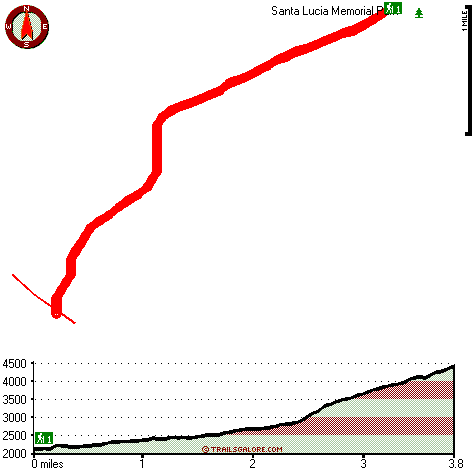
Total in and out hiking length = 7.6 miles

Total climbing distance = 2.9 miles

Difficulty : Difficult

Casual Hiking Pace: 6.5 hours

Fast Hiking Pace: 4 hours

Total elevation difference: 2631 feet


Ventana Inn Big Sur, Big Sur
8 miles away
Situated on 243 acres, 1,200 feet above the Pacific Ocean. The property is known for its serene setting, rustic yet luxurious sophistication and romantic allure. Features include 26 newly remodeled su...
  
Valley Harvest Inn, Soledad
21 miles away
Welcome to the Valley Harvest Inn, located in Soledad, CA, the heart of the Salinas Valley and Monterey County wine country. Close to Pinnacles National Monument, Mission Soledad, and Monterey Bay, th...
User input for Arroyo Seco Trail, Santa Lucia Range, Monterey County, California:

Submit Input:
Your Name:
Write or Paste Input here:

Upload picture:      Review Guidelines


Outdoors Recreation Near Salinas, California
Very comprehensive list of a variety of outdoors recreation in the vicinity of Salinas, California, the metro area neareast to Arroyo Seco Trail. Find info on campgrounds, hiking trails, ski resorts, lakes, beaches, parks, whitewater and more.

Current weather conditions at Arroyo Seco Trail, Santa Lucia Range, Monterey County, California
WXPort

Local climate location: MONTEREY 14 miles away

Quality Inn King City, King City
25 miles away
The Quality Inn features free continental breakfast, free high-speed Internet and an outdoor pool. The rooms have hair dryers, coffee makers, irons and boards and all rooms feature microwaves and refr...

King City Days Inn, King City
25 miles away
Welcome to Days Inn King City where we have 46 beautiful rooms for your convenience. We are conveniently located off Hwy 101 halfway between Los Angeles and San Francisco in the middle of wine country...

More Hotels and Campgrounds Near Arroyo Seco Trail, Santa Lucia Range, Monterey County, California

OTHER_INFO
  Santa Lucia Range Campgrounds
Complete list of all the campgrounds in the Santa Lucia Range.

Santa Lucia Range Outdoors Info
Complete outdoors info for the Santa Lucia Range.

California Hiking Trails
Complete list of all hiking trails in California

Books about hiking trails in California
List of books available on Amazon.com about hiking trails in California.

California Outdoors Index
This is a very comprehensive index of outdoors activities in the great state of California.


TOPO
High quality water resistant topo map of Arroyo Seco Trail, Santa Lucia Range, Monterey County, California.

OUTDOORS_GUIDE
These outdoors activities are available near Arroyo Seco Trail.
 Trails Near Arroyo Seco Trail:
North Coast Ridge Trail, Monterey County , 3 miles away, 9 hiking miles, 1385 feet elevation difference
Gamboa Trail, Monterey County , 3 miles away,  6.6 hiking miles, 1759 feet elevation difference
Girard Trail, Monterey County , 4 miles away, 5.1 hiking miles, 3407 feet elevation difference
Summit Trail, Monterey County , 5 miles away, 1.8 hiking miles, 1522 feet elevation difference
Marble Peak Trail, Monterey County , 7 miles away, 1.6 hiking miles, 1188 feet elevation difference
Horse Pasture Trail, Monterey County , 8 miles away, 5.3 hiking miles, 1737 feet elevation difference
Hot Springs Trail, Monterey County , 8 miles away,  4.4 hiking miles, 1545 feet elevation difference
 Camp Grounds Near Arroyo Seco Trail:
Gamboa Campground, Monterey County, 3 miles away
Ojito Campground, Monterey County, 3 miles away
Hanging Valley Campground, Monterey County, 4 miles away
Goat Campground, Monterey County, 4 miles away
Fresno Campground, Monterey County, 4 miles away
 Whitewater Near Arroyo Seco Trail:
Arroyo Seco River, Monterey County County , 7 miles away, Class IV(V) - 3 miles long (Willowcreek Bridge to Arroyo Seco Picnic Area)
Arroyo Seco River, Monterey County County , 11 miles away, Class III - 14.5 miles long (Arroyo Seco Picnic Area to Route G16 bridge)
San Antonio, Monterey County County , 13 miles away, Class II - 10.7 miles long (Above and down to Mission San Antonio de Padua)
 National Parks Near Arroyo Seco Trail:
Pinnacles National Monument, Paicines - CA , 41 miles away
 Hotels Near Arroyo Seco Trail:
Ventana Inn Big Sur, Big Sur , 8 miles away
Valley Harvest Inn, Soledad , 21 miles away
Quality Inn King City, King City , 25 miles away
King City Days Inn, King City , 25 miles away
Country Garden Inns, Carmel Valley , 27 miles away

Outdoors related information copyright © Stratus-Pikpuk, Inc. - Detailed hotel information copyright © Interactive Hotel Solutions