| |
|
| | While visiting this region in California it's a brilliant idea to go backpacking too. Can’t wait to get out in the great outdoors, Arch Point Loop Trail in Santa Barbara County, California is a splendid pick. There are hiking and backpacking trails all over California; Arch Point Loop Trail in Santa Barbara County is one of them. It's a lengthy journey from Oxnard-Thousand Oaks-Ventura to Arch Point Loop Trail, but hiking it is always enjoyable. Here in the nice state of California hiking never gets boring. This neighborhood does get very dry sometimes, |
|
so don’t forget to check for any current fire restrictions before you go. Arch Point Loop Trail is a one trailhead great outdoors trail, so in and out is the way to trek it normally. This backpacking trail is a very short backpacking trail having an average number of uphill miles
| | which makes it a magnificent wilderness hiking trail for the average person looking for a magnificent adventure. The total elevation difference for Arch Point Loop Trail is 430 feet which is a lower than average number. Arch Point Loop Trail stays roughly within the same elevation zone the whole time, so you get pretty much the same conditions along the whole hiking trail. This backcountry hiking trail is not that long but you should still bring some emergency supplies just in case something happens. Being 3 miles long it's shorter than many hiking trails. | |
|
Please follow all local rules about fires and camping. The time needed for this hike is roughly 2.5 hours, but you never know stuff could go wrong and you could get stuck so be prepared for that. This is one of a very small number of wilderness hiking trails in this area. Through
the summer months at Arch Point Loop Trail temperatures are commonly in the 70's. When the night sets in temperatures plunge down into the 50's. For the duration of the wintertime this spot gets highs in the 60's; overnight lows in the 40's for Arch Point Loop Trail. There are
numerous hiking and backpacking trails in California, and each one is gorgeous in its own way. Arch Point Loop Trail is pretty arid mostly; February is the wettest month with most rain, and July meanwhile is the driest month.
Briefly about the general area: Arch Point is in the vicinity and always pleasant to have a look at, and you could always discover Cave Canyon.
|
|
Location of Trailhead: Latitude 33.4802, Longitude -119.03 - - Directions and Road Map
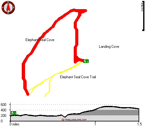
Total in and out hiking length = 3 miles
Total climbing distance = 1.2 miles
Difficulty : Medium
Casual Hiking Pace:
2.5 hours
Fast Hiking Pace:
1.5 hours
Total elevation difference: 430 feet

Malibu Country Inn, Malibu
|
34 miles away
Charming country inn, located in the bluffs overlooking the Pacific Ocean. Built in 1947, this cape-cod style inn offers intimate and private accommodations to our guests. We offer a variety of room...
|
| |
|
User input for Arch Point Loop Trail, Santa Barbara County, California:

Outdoors Recreation Near Oxnard-Thousand Oaks-Ventura, California Very comprehensive list of a variety of outdoors recreation in the vicinity of Oxnard-Thousand Oaks-Ventura, California, the metro area neareast to Arch Point Loop Trail. Find info on campgrounds, hiking trails, ski resorts, lakes, beaches, parks, whitewater and more.
More Hotels and Campgrounds Near Arch Point Loop Trail, Santa Barbara County, California
| |
|
| These outdoors activities are available near Arch Point Loop Trail. |
| | Trails Near Arch Point Loop Trail:
 |
Elephant Seal Cove Trail, Santa Barbara
County
, 1 miles away, 3 hiking miles, 416 feet elevation difference |
 |
Signal Peak Loop Trail, Santa Barbara
County
, 1 miles away, 3.1 hiking miles, 529 feet elevation difference |
|
| | Hotels Near Arch Point Loop Trail:
 |
Malibu Country Inn, Malibu
, 34 miles away |
 |
Country Inn & Suites By Carlson Port Hueneme, Port Hueneme
, 40 miles away |
 |
Malibu Beach Inn, Malibu
, 40 miles away |
 |
Americas Best Value Inn-Port Hueneme, Port Hueneme
, 40 miles away |
 |
The Malibu Motel, Malibu
, 41 miles away |
|
|
|
 |
|