California hiking trails - Ano Nuevo Trail, Santa Cruz Mountains, San Mateo County

   
  Ok, you've been cooped up too long, time to get out in nature a bit, and if you happen to be in San Mateo County of California, Ano Nuevo Trail is a glorious local backcountry hiking trail for doing a bit of leg stretching. Pretty far from Santa Cruz-Watsonville you locate Ano Nuevo Trail, but it is a glorious escape from the city. Great outdoors trails are perfect and plentiful in California, and Ano Nuevo Trail is one of them, and it's in San Mateo County. Please follow all local rules about fires and camping. Ano Nuevo Trail stays roughly within the
    same elevation zone the whole time which means the conditions are about the same from start to finish. Ano Nuevo Trail gets a typical amount of yearly rainfall; the month with most of the rain is January while July is generally the driest month. Throughout the days of summer at
Ano Nuevo Trail highs are typically in the 60's. Summer nighttime lows fall down to the 50's. For the duration of the winter highs are in the 50's, and nighttime lows at Ano Nuevo Trail throughout the winter commonly fall into the 40's. The beautiful great outdoors hiking trails of the Santa Cruz Mountains are a really brilliant way to spend quality time in the wilderness. This backpacking trail has a total elevation difference of 1,082 feet, and that is about average. This is not a very long backcountry hiking trail but you should still bring some emergency  
supplies just in case something happens. This is one of many backpacking and hiking trails in the surrounding neighborhood. With its 3.2 miles of walking distance it's a short backpacking trail. Going for a walk here in California is something that is always fun to do. Ano Nuevo Trail is a very short great outdoors hiking trail having an average number of uphill miles which makes this backpacking and hiking trail good for the average trekker looking for an enjoyable adventure. Hiking here in California is a must. This is a one trailhead backpacking trail, so in and out is the way to hike it normally. This area does get very dry sometimes, so do check for current fire restrictions before you go if you plan to bring a stove or make a camp fire. You should count on this backcountry trek taking about 2.5 hours, but you never know stuff could go wrong and you could get stuck so be prepared for that. There are numerous wilderness trails in California, and each one is different from the others.

Briefly about the general area:
A perfect beach close to Ano Nuevo Trail is Cove Beach, and if you came for an overnight stay Butano State Park is a brilliant place to camp. And that's not all the things you can do here in the Santa Cruz Mountains. A journey to Juan Bautista De Anza National Historic Trail is recommended, and some nearby water includes Old Womans Creek.
Whohoo, so many entertaining things in one place! Ano Nuevo Trail is peerless!. Beaches are nice; and Arroyo De Los Frijoles Beach close to Ano Nuevo Trail is no exception, and Costanoa Resort is a perfect local campground. A nice place for whitewater paddling near Ano Nuevo Trail is Pescadero Creek, and why not take a little trip to Little Butano Creek if you're here.

Location of Trailhead: Latitude 37.1852, Longitude -122.3354
- - Directions and Road Map

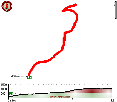
Total in and out hiking length = 3.2 miles

Total climbing distance = 1.2 miles

Difficulty : Medium

Casual Hiking Pace: 2.5 hours

Fast Hiking Pace: 1.5 hours

Total elevation difference: 1082 feet


Costanoa, Pescadero
3 miles away
Connected to four state parks, 30,000 acres of hiking trails and a vibrant wildlife reserve, Costanoa offers the unique opportunity to experience outdoor living in comfortable, stylish surroundings. A...
  
Pescadero Creek Inn, Pescadero
5 miles away
Located on the California coast one hour south of San Francisco at the edge of the historic town of Pescadero, the Pescadero Creek Inn is a 100 year-old farmhouse with three guest rooms in the main ho...
User input for Ano Nuevo Trail, Santa Cruz Mountains, San Mateo County, California:

Submit Input:
Your Name:
Write or Paste Input here:

Upload picture:      Review Guidelines


Outdoors Recreation Near Santa Cruz-Watsonville, California
Very comprehensive list of a variety of outdoors recreation in the vicinity of Santa Cruz-Watsonville, California, the metro area neareast to Ano Nuevo Trail. Find info on campgrounds, hiking trails, ski resorts, lakes, beaches, parks, whitewater and more.

Current weather conditions at Ano Nuevo Trail, Santa Cruz Mountains, San Mateo County, California
WXPort

Local climate location: HALF MOON BAY 6 miles away

The Ritz-Carlton Half Moon Bay, Half Moon Bay
14 miles away
The Ritz-Carlton Half Moon Bay sparkles with excellence. This AAA Five-Diamond resort is set atop a bluff overlooking the northern California coastline and offers the finest personalized service in a ...

Best Western Half Moon Bay Lodge, Half Moon Bay
15 miles away
Best Western Half Moon Bay Lodge is located on Highway 1 in the quaint northern California coastal city of Half Moon Bay. The Best Western Half Moon Bay Lodge is an attractive Hacienda-style hotel wit...

More Hotels and Campgrounds Near Ano Nuevo Trail, Santa Cruz Mountains, San Mateo County, California

OTHER_INFO
  Santa Cruz Mountains Campgrounds
Complete list of all the campgrounds in the Santa Cruz Mountains.

Santa Cruz Mountains Outdoors Info
Complete outdoors info for the Santa Cruz Mountains.

California Hiking Trails
Complete list of all hiking trails in California

Books about hiking trails in California
List of books available on Amazon.com about hiking trails in California.

California Outdoors Index
This is a very comprehensive index of outdoors activities in the great state of California.


TOPO
High quality water resistant topo map of Ano Nuevo Trail, Santa Cruz Mountains, San Mateo County, California.

OUTDOORS_GUIDE
These outdoors activities are available near Ano Nuevo Trail.
 Trails Near Ano Nuevo Trail:
Butano Ridge Loop Trail, San Mateo County , 8 miles away,  4.2 hiking miles, 1656 feet elevation difference
Sequoia Nature Trail, San Mateo County , 8 miles away,  .4 hiking miles, 32 feet elevation difference
Coyote Ridge Trail, San Mateo County , 8 miles away, 1.2 hiking miles, 549 feet elevation difference
Summit Trail, San Mateo County , 9 miles away,  3 hiking miles, 506 feet elevation difference
Alambique Trail, San Mateo County , 12 miles away,  6.4 hiking miles, 818 feet elevation difference
Trappers Trail, San Mateo County , 13 miles away, 2.3 hiking miles, 1148 feet elevation difference
 Camp Grounds Near Ano Nuevo Trail:
Butano State Park, San Mateo, 2 miles away
Costanoa Resort, Pescadero, 3 miles away
Santa Cruz North / Costanoa KOA, Pescadero, 4 miles away
Big Basin Tent Cabins, Boulder Creek, 8 miles away
Blooms Creek Campground, Santa Cruz County, 8 miles away
 Beaches Near Ano Nuevo Trail:
Cove Beach, San Mateo County , 5 miles away
Arroyo De Los Frijoles Beach, San Mateo County , 6 miles away
Pebble Beach, San Mateo County , 6 miles away
Pescadero Beach, San Mateo County , 7 miles away
Sand Beach, San Mateo County , 7 miles away
 Whitewater Near Ano Nuevo Trail:
Pescadero Creek, San Mateo County County , 6 miles away, Class II - 9 miles long (Portola State Park to Memorial County Park)
 National Parks Near Ano Nuevo Trail:
Juan Bautista De Anza National Historic Trail, San Francisco - CA , 24 miles away
Golden Gate National Recreation Area, San Francisco - CA , 34 miles away
Presidio National Park, San Francisco - CA , 34 miles away
 Hotels Near Ano Nuevo Trail:
Costanoa, Pescadero , 3 miles away
Pescadero Creek Inn, Pescadero , 5 miles away
The Ritz-Carlton Half Moon Bay, Half Moon Bay , 14 miles away
Best Western Half Moon Bay Lodge, Half Moon Bay , 15 miles away
Zaballa House, Half Moon Bay , 16 miles away
 Lakes Near Ano Nuevo Trail
Bean Hollow Lake, San Mateo County , 3 miles away

Outdoors related information copyright © Stratus-Pikpuk, Inc. - Detailed hotel information copyright © Interactive Hotel Solutions