California hiking trails - Alambique Trail, Santa Cruz Mountains, San Mateo County

   
  Backpacking trails for backcountry hiking, and backpacking can be found all over California; one of them being Alambique Trail in San Mateo County. Time to get out, and breathe some fresh air, and Alambique Trail in San Mateo County, California is just what you need. Every single California great outdoors hiking trail is well worth a backcountry hike. The warmest time of the year at Alambique Trail comes with high temperatures in the 70's, and the nighttime is slightly colder of course, mostly in the 50's. Daytime highs during the wintertime are in the
    50's, and after the sun is down during the wintertime temperatures at Alambique Trail fall into the 40's. This part of California has a splendid deal of available outdoors pursuits. Alambique Trail is generally a rather dehydrated place; through January this region sees the most
rain, and July meanwhile is the driest month. There are so many backpacking trails in this vicinity. This is a long great outdoors hiking trail, so make sure you bring plenty of supplies. This region does get very dry sometimes, so do check for current fire restrictions before you go if you plan to bring a stove or make a camp fire. Alambique Trail is not very in the vicinity of San Francisco-Oakland-Fremont at all, but it's one of those places where backcountry trekking is great. The length of this trail is about average having an average number of  
uphill miles which makes this a very tough backpacking trail for advanced walkers looking for a great challenge. If you happen to be in California, why not go backcountry hiking, it is a magnificent idea. This walk shouldn't take more than 5.5 hours, but of course some folks walk a bit slower and some a bit faster. These trails here in the Santa Cruz Mountains are the best way to enjoy these mountaintops. This hiking trail has only one trailhead, so you'll be backcountry trekking it in and back out. And keep in mind that there could be temporary safety restrictions in spot. This hiking trail has a total elevation difference of 818 feet which is lower than average. There's not much difference in elevation along Alambique Trail, so you won’t have to worry about different climate zones along your hike. With its 6.4 miles of walking distance it's a mid length hike.

Briefly about the general area:
A pleasant trip to The Meadows is a wonderful way to spend an afternoon; a great location to camp here at Alambique Trail is Trailer Villa. That right there is a lot of amusing stuff already but it goes on, the Santa Cruz Mountains has it all. Alambique Creek flows through this area, and Summit Spring is always fun to check out.
I can't stop, cause I'm havin' a great time here at Alambique Trail. There's some flowing water close by, Martin Creek is a stream you can have a look at during your stay; Bear Gulch is close at hand, and is a perfect site. All our national parks are tremendous places to check out, and Juan Bautista De Anza National Historic Trail is no exception, and lots of folks from San Francisco-Oakland-Fremont come here. You'll beyond doubt wish for more hours in a day to enjoy all the fun stuff in the Santa Cruz Mountains.
Soar down the rapids of Pescadero Creek in a kayak, and why not camp at Trailer Rancho while you're here at Alambique Trail.

Location of Trailhead: Latitude 37.399, Longitude -122.293
- - Directions and Road Map

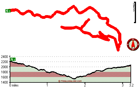
Total in and out hiking length = 6.4 miles

Total climbing distance = 2.8 miles

Difficulty : Difficult

Casual Hiking Pace: 5.5 hours

Fast Hiking Pace: 3.5 hours

Total elevation difference: 818 feet


Americas Best Inns-Redwood City, Redwood City
6 miles away
Americas Best Inns Redwood City Is Conveniently Located 1/2 Mile West Of Hwy. 101 -Halfway Between San Francisco And San Jose Airports -With Several Restaurants Within Walking Distance. We Feature Sin...
  
Sequoia Inn, Redwood City
6 miles away
Sequoia Inn is conveniently located in beautiful Redwood City near major highways, restaurants, and downtown. We are 20 minutes away from San Francisco Airport and about 30 minutes away from San Jose ...
User input for Alambique Trail, Santa Cruz Mountains, San Mateo County, California:

Submit Input:
Your Name:
Write or Paste Input here:

Upload picture:      Review Guidelines


Outdoors Recreation Near San Francisco-Oakland-Fremont, California
Very comprehensive list of a variety of outdoors recreation in the vicinity of San Francisco-Oakland-Fremont, California, the metro area neareast to Alambique Trail. Find info on campgrounds, hiking trails, ski resorts, lakes, beaches, parks, whitewater and more.

Current weather conditions at Alambique Trail, Santa Cruz Mountains, San Mateo County, California
WXPort

Local climate location: SAN FRANCISCO WSO AP 3 miles away

Best Western Inn, Redwood City
6 miles away
Experience the peaceful environment of Redwood City. Twenty-five minutes from downtown San Francisco, this pleasant community lies on the Bay Area's West Peninsula, adjacent to Stanford University and...

Comfort Inn Redwood City, Redwood City
6 miles away

More Hotels and Campgrounds Near Alambique Trail, Santa Cruz Mountains, San Mateo County, California

OTHER_INFO
  Santa Cruz Mountains Campgrounds
Complete list of all the campgrounds in the Santa Cruz Mountains.

Santa Cruz Mountains Outdoors Info
Complete outdoors info for the Santa Cruz Mountains.

California Hiking Trails
Complete list of all hiking trails in California

Books about hiking trails in California
List of books available on Amazon.com about hiking trails in California.

California Outdoors Index
This is a very comprehensive index of outdoors activities in the great state of California.


TOPO
High quality water resistant topo map of Alambique Trail, Santa Cruz Mountains, San Mateo County, California.

OUTDOORS_GUIDE
These outdoors activities are available near Alambique Trail.
 Trails Near Alambique Trail:
Edgewood Trail, San Mateo County , 4 miles away, 1.2 hiking miles, 198 feet elevation difference
Trappers Trail, San Mateo County , 6 miles away, 2.3 hiking miles, 1148 feet elevation difference
Coyote Ridge Trail, San Mateo County , 9 miles away, 1.2 hiking miles, 549 feet elevation difference
Sequoia Nature Trail, San Mateo County , 9 miles away,  .4 hiking miles, 32 feet elevation difference
Butano Ridge Loop Trail, San Mateo County , 9 miles away,  4.2 hiking miles, 1656 feet elevation difference
Summit Trail, San Mateo County , 9 miles away,  3 hiking miles, 506 feet elevation difference
Ano Nuevo Trail, San Mateo County , 12 miles away,  3.2 hiking miles, 1082 feet elevation difference
 Camp Grounds Near Alambique Trail:
Trailer Villa, Redwood City, 8 miles away
Trailer Rancho, Redwood City, 8 miles away
Santa Cruz North / Costanoa KOA, Pescadero, 10 miles away
Portola Redwoods State Park, San Mateo, 11 miles away
Butano State Park, San Mateo, 11 miles away
 Whitewater Near Alambique Trail:
Pescadero Creek, San Mateo County County , 8 miles away, Class II - 9 miles long (Portola State Park to Memorial County Park)
 National Parks Near Alambique Trail:
Juan Bautista De Anza National Historic Trail, San Francisco - CA , 17 miles away
Golden Gate National Recreation Area, San Francisco - CA , 24 miles away
Presidio National Park, San Francisco - CA , 24 miles away
 Hotels Near Alambique Trail:
Americas Best Inns-Redwood City, Redwood City , 6 miles away
Sequoia Inn, Redwood City , 6 miles away
Best Western Inn, Redwood City , 6 miles away
Comfort Inn Redwood City, Redwood City , 6 miles away
Holiday Inn Express REDWOOD CITY-CENTRAL, Redwood City , 6 miles away
 Lakes Near Alambique Trail
Bear Gulch Reservoir, San Mateo County , 4 miles away

Outdoors related information copyright © Stratus-Pikpuk, Inc. - Detailed hotel information copyright © Interactive Hotel Solutions