| |
|
| | It's a long tour from Santa Barbara-Santa Maria-Goleta to Agua Caliente Trail, but it is a fine sanctuary from the urban center. California has so much to offer the wilderness lovers. Each trail in California has its own character. This is a long wilderness trail, so don't forget to pack enough supplies. Trails like this one here in the Sierra Madre are a very wonderful way to see these mountains. Agua Caliente Trail is pretty dehydrated typically; of all the months in a year February is the one with the most rain; the driest of the months is July. Hiking |
|
trails for trekking, and backpacking can be found all over California; one of them being Agua Caliente Trail in Santa Barbara County. Different parts of Agua Caliente Trail are at very different elevations, so keep in mind that you may need to dress differently at different elevations.
| | Being 17 miles long; it's a long wilderness hiking trail. Agua Caliente Trail is a very long backcountry hiking trail having an average number of uphill miles which makes this backpacking trail magnificent for hard core backpackers looking for adventure. Time to get out, and breathe some fresh air, and Agua Caliente Trail in Santa Barbara County, California is just the location. Backpacking in California is always an exciting thing to do. This is one of many backpacking trails in the surrounding vicinity. This area does get very dry sometimes, so do check | |
|
for current fire restrictions before you go if you plan to bring a stove or make a camp fire. Agua Caliente Trail is a one trailhead hiking and backpacking trail, so you'll be backcountry backpacking it in and back out. At Agua Caliente Trail during the summer months highs are
in the 90's while nighttime lows are commonly in the 50's. The wintertime brings highs down to the 60's while Agua Caliente Trail nighttime low temperatures through the wintertime are in the 30's. The total elevation difference for this hiking and backpacking trail is 2,537 feet
which is a higher than average number. Now, this is roughly a 2.5-day hike, so better have big backpack to fit all the stuff you need. Don’t forget to check for any current restrictions or closures before you go.
Briefly about the general area: Getting to North Fork
Juncal Creek from Agua Caliente Trail is trouble-free, and if you're here why not have a look at East Fork Diablo Canyon. While you're here at Agua Caliente Trail it's a nice idea to stop by Billiard Flats, and if you came for an overnight stay Don Victor Campground is a great
place to camp. If you want a glorious time in the great outdoors, just come on down to Agua Caliente Trail. A short trip to Agua Caliente Spring is always worthwhile, and you should beyond doubt dedicate some time to Don Victor Valley if you're here at Agua Caliente Trail.
All the outdoors enjoyable things in the Sierra Madre will keep you coming back repeatedly. Not enough hours in a day to enjoy the Sierra Madre. Take a little journey to Lacosca Creek if you're here at Agua Caliente Trail, and Juncal Campground is a nice local campground. La Carpa Spring is always fun to check out, and if you're looking for a glorious visit, Channel Islands National Park is reasonably near.
|
|
Location of Trailhead: Latitude 34.5453, Longitude -119.5609 - - Directions and Road Map
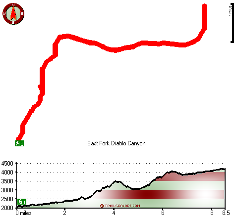
Total in and out hiking length = 17 miles
Total climbing distance = 7.4 miles
Difficulty : Difficult
Casual Hiking Pace:
2.5 days
Fast Hiking Pace:
1.5 days
Total elevation difference: 2537 feet

Sandyland Reef Inn, Carpinteria
|
10 miles away
Located conveniently close to the beach and visible from Freeway 101, Sandyland Reef Inn is beautifully built with Santa Barbara charm. Just 1 mile from downtown Carpinteria and 10 miles South of Sant...
|
| |
Best Western Carpinteria Inn, Carpinteria
|
10 miles away
Stay at this Carpinteria, California hotel and enjoy the scenic countryside and the world's safest beaches. The Best Western Carpinteria Inn is conveniently located with easy access to key area attr...
|
|
User input for Agua Caliente Trail, Sierra Madre, Santa Barbara County, California:

Outdoors Recreation Near Santa Barbara-Santa Maria-Goleta, California Very comprehensive list of a variety of outdoors recreation in the vicinity of Santa Barbara-Santa Maria-Goleta, California, the metro area neareast to Agua Caliente Trail. Find info on campgrounds, hiking trails, ski resorts, lakes, beaches, parks, whitewater and more.
More Hotels and Campgrounds Near Agua Caliente Trail, Sierra Madre, Santa Barbara County, California
| |
| |
 |
|
| These outdoors activities are available near Agua Caliente Trail. |
| | Trails Near Agua Caliente Trail:
 |
Roblar Trail, Santa Barbara
County
, 3 miles away, 10.5 hiking miles, 2696 feet elevation difference |
 |
Upper Mono Trail, Santa Barbara
County
, 4 miles away, 12.8 hiking miles, 2097 feet elevation difference |
 |
Don Victor Valley Fire Trail, Santa Barbara
County
, 5 miles away, 9.4 hiking miles, 2021 feet elevation difference |
 |
The Caracole, Santa Barbara
County
, 6 miles away, 6.2 hiking miles, 1274 feet elevation difference |
 |
Mono Alamar Trail, Santa Barbara
County
, 6 miles away, 9.4 hiking miles, 1332 feet elevation difference |
 |
Blue Canyon Trail, Santa Barbara
County
, 7 miles away, 4.7 hiking miles, 741 feet elevation difference |
 |
Franklin Trail, Santa Barbara
County
, 7 miles away, 8 hiking miles, 2209 feet elevation difference |
|
| | Hotels Near Agua Caliente Trail:
 |
Sandyland Reef Inn, Carpinteria
, 10 miles away |
 |
Best Western Carpinteria Inn, Carpinteria
, 10 miles away |
 |
Inn on Summer Hill, Summerland
, 11 miles away |
 |
Holiday Inn Express Hotel & Suites Carpinteria, Carpinteria
, 11 miles away |
 |
Montecito Inn, Santa Barbara
, 12 miles away |
|
|
|
 |
|