| |
|
| | Here in the good state of California backcountry backpacking is the good thing to do. You can't spend all your time indoors you need to get out once in a while, and Agua Blanca Trail in Ventura County, California is the fresh air at its best. California has plenty of good trails; Agua Blanca Trail in Ventura County is one of them. It is very dried up here at Agua Blanca Trail regularly; February is the wettest month with most rain while July is regularly the driest month. Agua Blanca Trail is many miles long with an average amount of climbing distance which |
|
makes this backcountry hiking trail great for hard core backpackers looking for adventure. Hiking here in California is a must. Agua Blanca Trail is 20.2 miles long; it's longer than many great outdoors hiking trails. Summertime highs at Agua Blanca Trail regularly tend to be in
| | the 90's. Throughout the dark hours of summer temperatures sink down into the 50's. Throughout the winter highs are generally in the 60's while the cold winter nights at Agua Blanca Trail are in the 30's. Every California trail is well worth a backcountry trek. Sometimes this backcountry trail gets really dry, so do check for current fire restrictions before you go if you plan to bring a stove or make a camp fire. This is a region covered with lots of backcountry hiking trails. This is a long backcountry trail, so don't forget to pack enough supplies. This hike | |
|
should take you about 3 days, so better have big backpack to fit all the stuff you need. The lovely hiking trails of the Sierra Madre are the best way to enjoy these mountaintops. Agua Blanca Trail is a long drive away from Oxnard-Thousand Oaks-Ventura, but when you spend some
time trekking here you will feel like a whole new person. Agua Blanca Trail has a total elevation difference of 6,134 feet, and that is higher than average. Please follow all local rules about fires and camping. Agua Blanca Trail goes through some very different elevations, so
keep in mind that you may need to dress differently at different elevations.
Briefly about the general area: Agua Blanca Trail is nice enough to spend more than a day at, Cove Campground is a nice local campground; whitewater paddling is good on Piru Creek. Places like
The Pothole are brilliant to check out, and hey, Lacosca Creek is a delightful local stream. But wait, there's more cool stuff to do in the Sierra Madre. There's so much to do here at Agua Blanca Trail that you need to camp here for a while, Tin Can Cabin Campground is a great
spot for that, and Halfway Spring is always fun to check out. Having a delightful time in the Sierra Madre is painless. Devils Potrero is a charming site any time of year, and if you're looking for some flowing water? Try Sulphur Creek. Not far from Agua Blanca Trail you stumble
on Nugget Point, and Big Narrows is a fine spot to spend some time. Be careful coming to Agua Blanca Trail, you might not ever wanna go home again. Cobblestone Spring is a scenic spot to stop at while you're at Agua Blanca Trail; get wet paddling on Piru Creek. There's a forest here at Agua Blanca Trail called Kenney Groye.
|
|
Location of Trailhead: Latitude 34.5771, Longitude -118.8856 - - Directions and Road Map
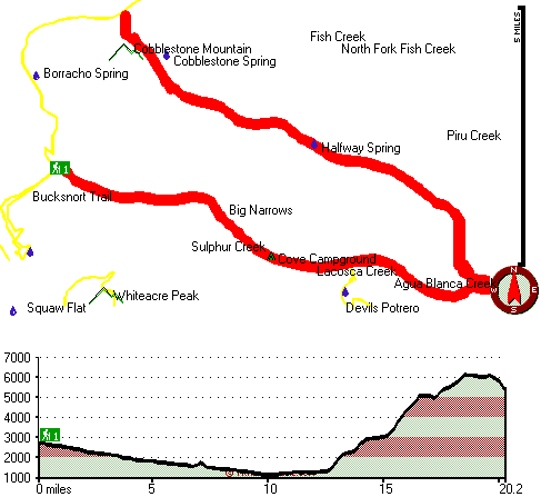
Total hiking length = 20.2 miles
Total climbing distance = 7 miles
Difficulty : Difficult
Casual Hiking Pace:
3 days
Fast Hiking Pace:
9 hours
Total elevation difference: 6134 feet

Best Western La Posada Motel, Fillmore
|
11 miles away
Stay at this Fillmore, California motel 20 miles from the beaches of the Pacific Ocean along the scenic California coastline. The Best Western La Posada Motel in Fillmore, CA is conveniently located ...
|
| |
Econo Lodge Gorman, Gorman
|
13 miles away
The Econo Lodge is conveniently located on Interstate 5, at the top of the grapevine between Bakersfield and Los Angeles, and just 5 miles from Lebec, just 30 minutes from Six Flags Magic Mountain. We...
|
|
User input for Agua Blanca Trail, Sierra Madre, Ventura County, California:

Outdoors Recreation Near Oxnard-Thousand Oaks-Ventura, California Very comprehensive list of a variety of outdoors recreation in the vicinity of Oxnard-Thousand Oaks-Ventura, California, the metro area neareast to Agua Blanca Trail. Find info on campgrounds, hiking trails, ski resorts, lakes, beaches, parks, whitewater and more.
|
Current weather conditions at Agua Blanca Trail, Sierra Madre, Ventura County, California

Local climate location: OJAI 26 miles away

           
| |
Best Rest Inn Lebec Frazier, Lebec
|
15 miles away
You will enjoy clean- comfortable rooms at an affordable price at the BestRest Inn. Start each day with a complimentary deluxe continental breakfast with hot fresh waffles. Relax in guestrooms complet...
|
Holiday Inn Express Hotel & Suites FRAZIER PARK, Lebec
|
15 miles away
Welcome to the beautiful newly built Holiday Inn Express Hotel & Suites Frazier Park located just minutes from outdoor adventure, fishing, skiing, snowboarding, mountain biking, hiking and camping. En...
|
|
More Hotels and Campgrounds Near Agua Blanca Trail, Sierra Madre, Ventura County, California
| |
| |
 |
|
| These outdoors activities are available near Agua Blanca Trail. |
| | Trails Near Agua Blanca Trail:
 |
Whiteacre Peak Trail, Ventura
County
, 3 miles away, 4.5 hiking miles, 1954 feet elevation difference |
 |
Bucksnort Trail, Ventura
County
, 3 miles away, 5.6 hiking miles, 1286 feet elevation difference |
 |
White Mountain Trail, Ventura
County
, 3 miles away, 19.4 hiking miles, 3500 feet elevation difference |
 |
Pothole Trail, Ventura
County
, 5 miles away, 10.6 hiking miles, 2168 feet elevation difference |
 |
Upper Sespe River Trail, Ventura
County
, 6 miles away, 14 hiking miles, 1682 feet elevation difference |
 |
Bailey Trail, Los Angeles
County
, 6 miles away, 7.2 hiking miles, 1111 feet elevation difference |
 |
Snowy Creek Trail, Ventura
County
, 7 miles away, 7.1 hiking miles, 3899 feet elevation difference |
|
| | Whitewater Near Agua Blanca Trail:
 |
Piru Creek, Los Angeles / Ventura County
County
, 6 miles away, Class IV - 15 miles long (Pyramid Lake to Lake Piru) |
 |
Piru Creek, Ventura County
County
, 9 miles away, Class II - 4 miles long (Lake Piru to Santa Clara River) |
 |
Sespe Creek, Ventura County
County
, 15 miles away, Class IV-V - 31.5 miles long (Lion Campground to Highway 126 bridge) |
 |
Kern River, Kern County
County
, 50 miles away, Class II-IV - 4.8 miles long (Mouth of canyon to Lake Ming) |
 |
Kern River, Kern County
County
, 53 miles away, Class V+ - 12 miles long (Democrat Hot Springs to mouth of canyon) |
|
| | Hotels Near Agua Blanca Trail:
 |
Best Western La Posada Motel, Fillmore
, 11 miles away |
 |
Econo Lodge Gorman, Gorman
, 13 miles away |
 |
Best Rest Inn Lebec Frazier, Lebec
, 15 miles away |
 |
Holiday Inn Express Hotel & Suites FRAZIER PARK, Lebec
, 15 miles away |
 |
Rodeway Inn Magic Mountain Area, Castaic
, 16 miles away |
|
|
|
 |
|