| |
|
| | It's a long drive from Prescott to Wilson Mountain Trail, but what a good place for hiking it is. Arizona is a brilliant outdoors state. Finally, hiking time is here again, and if you happen to be in Coconino County of Arizona, Wilson Mountain Trail is a good local wilderness hiking trail for doing a bit of leg stretching. This is a backcountry trail that is quite long, so don't forget to pack enough supplies. Every single Arizona backcountry hiking trail has its own unique splendor. Some parts of this trail are much higher up than other parts of the |
|
trail which of course means you need to be prepared for different conditions on different parts of the trail. Arizona has plenty of nice backcountry hiking trails, and one of those is Wilson Mountain Trail in Coconino County. For the period of the long summer days highs here at
| | Wilson Mountain Trail get into the 80's. For the duration of the moonlight hours it's commonly in the 40's. The wintertime comes with highs in the 40's; nighttime lows at Wilson Mountain Trail through the wintertime commonly drop into the 0's. Here in Arizona backcountry trekking is a magnificent way to spend some time. The total elevation difference for this backpacking and hiking trail is 3,076 feet which is a higher than average number. This walk shouldn't take more than 6 hours, but of course some people walk a bit slower and some a bit faster. This | |
|
backcountry trail sometimes gets very dry, so make sure you check current conditions and fire restrictions with local forest authorities before you head out. Wilson Mountain Trail gets very little rainfall; the month with most of the rain is August, and June on the other hand is
the driest. This is a one trailhead backpacking and hiking trail, so you're looking at an in and out backcountry trek. The length of Wilson Mountain Trail is about average with an average amount of climbing distance which makes this a very tough hiking and backpacking trail for
advanced hikers looking for a wonderful challenge. Wilson Mountain Trail is 7 miles long it's an average length trail. Don’t forget to check for any current restrictions or closures before you go. There are so many hiking and backpacking trails in this vicinity.
Briefly
about the general area: There's some flowing water nearby, Soldier Wash is a stream you can take a look at during your stay. Visiting Montezuma Castle National Monument is just something you need to do if you haven't yet; Grasshopper Point Campground is a magnificent campground
here. Wilson Mountain Trail is a glorious place to camp, Hawkeye-red Rock RV Park is a glorious place, and float down the rapids of Wet Beaver Creek in a kayak. If you're here, you might as well go to Casner Canyon; paddling on Oak Creek is so much fun.
|
|
Location of Trailhead: Latitude 34.8886, Longitude -111.7416 - - Directions and Road Map
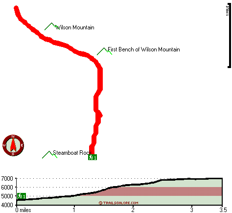
Total in and out hiking length = 7 miles
Total climbing distance = 2.4 miles
Difficulty : Difficult
Casual Hiking Pace:
6 hours
Fast Hiking Pace:
3.5 hours
Total elevation difference: 3076 feet

Hyatt Pinon Pointe, Sedona
|
Located in the heart of Sedona's Red Rock country. Most rooms are fully equipped comdominium units with fully equipped kitchens, dining rooms and fireplaces. Adjacent to the Shops at Pinion Point wh...
|
| |
Oak Creek Terrace Resort, Sedona
|
The Oak Creek Terrace Resort is nestled 4 miles from Sedona in Oak Creek Canyon between the beautiful red rock and tree covered canyon walls. Our grounds are lavishly planted with trees and shrubs. ...
|
|
User input for Wilson Mountain Trail, Coconino County, Arizona:

Outdoors Recreation Near Prescott, Arizona Very comprehensive list of a variety of outdoors recreation in the vicinity of Prescott, Arizona, the metro area neareast to Wilson Mountain Trail. Find info on campgrounds, hiking trails, ski resorts, lakes, beaches, parks, whitewater and more.
More Hotels and Campgrounds Near Wilson Mountain Trail, Coconino County, Arizona
| |
| |
 |
|
| These outdoors activities are available near Wilson Mountain Trail. |
| | Trails Near Wilson Mountain Trail:
 |
Vultee Arch Twenty Two, Coconino
County
, 3 miles away, 1.2 hiking miles, 161 feet elevation difference |
 |
A B Young Trail, Coconino
County
, 4 miles away, 2 hiking miles, 2179 feet elevation difference |
 |
Loy Butte Five, Yavapai
County
, 13 miles away, 4.8 hiking miles, 2111 feet elevation difference |
 |
Apache Maid Trail, Yavapai
County
, 14 miles away, 8 hiking miles, 2787 feet elevation difference |
 |
Dorsey Spring Trail, Coconino
County
, 16 miles away, 3 hiking miles, 689 feet elevation difference |
|
| | Whitewater Near Wilson Mountain Trail:
 |
Oak Creek, Coconino/ Yavapai County
County
, 11 miles away, Class -blank- - 35 miles long (Pump Stabove Sedona Cornville to Verde River) |
 |
Wet Beaver Creek, Yavapai County
County
, 14 miles away, Class -blank- - 9 miles long (Beaver Ranger Station to Beaver Creek) |
|
| | National Parks Near Wilson Mountain Trail:
 |
Montezuma Castle National Monument, Camp Verde - AZ
, 20 miles away |
 |
Tuzigoot National Monument, Clarkdale - AZ
, 20 miles away |
 |
Walnut Canyon National Monument, Flagstaff - AZ
, 22 miles away |
|
| | Hotels Near Wilson Mountain Trail:
 |
Hyatt Pinon Pointe, Sedona
, 1 miles away |
 |
Oak Creek Terrace Resort, Sedona
, 1 miles away |
 |
Best Western Arroyo Roble Hotel & Creekside Villas, Sedona
, 2 miles away |
 |
L Auberge De Sedona, Sedona
, 2 miles away |
 |
Orchards Inn of Sedona, Sedona
, 2 miles away |
|
|
|
 |
|