| |
|
| | Time to get out, and breathe some fresh air, and West Boulder Trail in Pinal County, Arizona is just what you need. There are plenty of great outdoors hiking trails in Arizona; each one of them has its own character. West Boulder Trail is a long drive away from Payson, but if you're looking for a nice spot to go trekking, this is a nice choice. With its 14.4 miles of walking distance; it's considered a longer walk. This is just one of a large number of wilderness hiking trails in this vicinity. This trek should take you about 2 days, so make sure you've |
|
got all your overnight gear packed. This is a long hiking trail, so do pack enough food to last the whole trip. West Boulder Trail is a very long backpacking trail with an average amount of climbing distance which makes it a wonderful wilderness hiking trail for experienced backcountry
| | trekkers in fine shape. West Boulder Trail goes through some very different elevations, and that means that some parts of the great outdoors hiking trail could be very different from other parts of it. Around West Boulder Trail you don’t get a lot of rain; during March this neighborhood sees the most rain while May is the month with the least amount of precipitation. West Boulder Trail has two trailheads, so backcountry backpacking it one way is an option if you can arrange for a ride back. Great outdoors trails for backpacking, and backpacking can be found all | |
|
over Arizona; West Boulder Trail is one of them, and it's in Pinal County. Don’t forget to check for any current restrictions or closures before you go. The total elevation difference for this wilderness trail is 1,623 feet, and that is about average. Backcountry trekking in Arizona
is so much fun. While visiting this neighborhood in Arizona it's a wonderful idea to go backcountry trekking too. Summertime at West Boulder Trail arrives with high temperatures in the 100's. For the duration of the dark hours of summer temperatures fall down into the 70's. For
the duration of the winter highs are in the 60's; through the dark hours in the wintertime at West Boulder Trail temperatures fall to the 30's. This hiking trail sometimes gets very dry, so do check for current fire restrictions before you go if you plan to bring a stove or make
a camp fire.
Briefly about the general area: West Boulder Trail is a wonderful spot to visit for more than one day, Carney Springs Campground is a wonderful spot to camp nearby, and if you're looking for some flowing water? Try La Barge Creek. You'll need more than a
day to look at everything West Boulder Trail has to offer, you can camp at Peralta Canyon Campground; do put some time aside to spend at Hieroglyphic Spring since you're here at West Boulder Trail. Old West Boulder Canyon is close to West Boulder Trail and is a perfect location,
and why not take a little journey to Mesquite Creek while you're here. But wait, there's more to do near West Boulder Trail. Don’t forget to visit Garden Valley while you're here at West Boulder Trail, and there are some splendid whitewater spots on Salt River. A tremendous spot like Marsh Valley here at West Boulder Trail is too glorious to miss It's always wonderful to visit Willow Spring.
|
|
Location of Trailhead 1: Latitude 33.3964, Longitude -111.367 - - Directions and Road Map
Location of Trailhead 2: Latitude 33.4665, Longitude -111.4283 - - Directions and Road Map

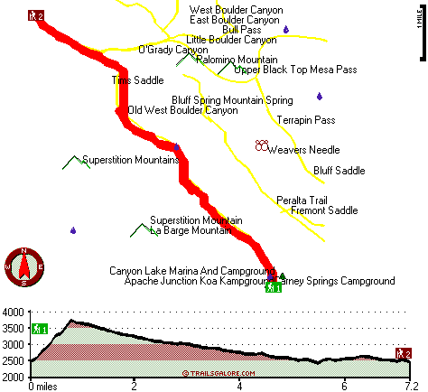
Trailhead 1 to Trailhead 2: Total hiking length = 7.2 miles Total climbing distance = 1.8 miles Difficulty : Difficult Casual Hiking Pace:
5.5 hours
Fast Hiking Pace:
3 hours
Trailhead 2 to Trailhead 1: Total hiking length = 7.2 miles Total climbing distance = 4.5 miles Difficulty : Difficult Casual Hiking Pace:
7.5 hours
Fast Hiking Pace:
4 hours
| | Trailhead 1 back to Trailhead 1: Total hiking length = 14.4 miles Total climbing distance = 6.3 miles Difficulty : Difficult Casual Hiking Pace:
2 days
Fast Hiking Pace:
8.5 hours
Trailhead 2 back to Trailhead 2: Total hiking length = 14.4 miles Total climbing distance = 6.3 miles Difficulty : Difficult Casual Hiking Pace:
2 days
Fast Hiking Pace:
8.5 hours
|
Total elevation difference: 1623 feet

Gold Canyon Golf Resort, Gold Canyon
|
5 miles away
The resorts 85 unique Casitas offer a variety of amenities such as Indoor or Outdoor Spas, Suites, Wood Burning Fireplaces, and Private Patios with splendid views of the majestic Superstition Mountain...
|
| |
Best Western Gold Canyon Inn & Suites, Gold Canyon
|
6 miles away
Discover this Gold Canyon hotel located next to the Superstition Mountains and offering a complimentary continental breakfast. Whether traveling on business or for pleasure, the Best Western Gold Can...
|
|
User input for West Boulder Trail, Pinal County, Arizona:

Outdoors Recreation Near Payson, Arizona Very comprehensive list of a variety of outdoors recreation in the vicinity of Payson, Arizona, the metro area neareast to West Boulder Trail. Find info on campgrounds, hiking trails, ski resorts, lakes, beaches, parks, whitewater and more.
More Hotels and Campgrounds Near West Boulder Trail, Pinal County, Arizona
| |
| |
 |
|
| These outdoors activities are available near West Boulder Trail. |
| | Trails Near West Boulder Trail:
 |
Black Mesa Trail, Maricopa
County
, 2 miles away, 8.2 hiking miles, 657 feet elevation difference |
 |
Needle Trail, Pinal
County
, 2 miles away, 9 hiking miles, 1203 feet elevation difference |
 |
Peralta Trail, Pinal
County
, 2 miles away, 11.2 hiking miles, 1340 feet elevation difference |
 |
Red Hills Trail, Maricopa
County
, 3 miles away, 9.6 hiking miles, 502 feet elevation difference |
 |
Boulder Trail, Maricopa
County
, 3 miles away, 13.6 hiking miles, 659 feet elevation difference |
 |
Cave Trail, Pinal
County
, 3 miles away, 4.4 hiking miles, 1711 feet elevation difference |
 |
Second Water Trail, Maricopa
County
, 4 miles away, 6 hiking miles, 534 feet elevation difference |
|
| | Whitewater Near West Boulder Trail:
 |
Salt River, Gila County
County
, 16 miles away, Class -blank- - 12 miles long (Stewart Mountain Dam to Granite Reef Dam) |
 |
Verde River, Maricopa County
County
, 22 miles away, Class I-II - 19 miles long (Bartlett Reservoir to confluence with Salt River) |
 |
Gila River, Pinal County
County
, 28 miles away, Class -blank- - 15 miles long (Kelvin to Ashurst-Hayden Dam) |
|
| | National Parks Near West Boulder Trail:
 |
Casa Grande Ruins National Monument, Coolidge - AZ
, 28 miles away |
 |
Hohokam Pima National Monument, Coolidge - AZ
, 28 miles away |
 |
Tonto National Monument, Roosevelt - AZ
, 29 miles away |
|
| | Hotels Near West Boulder Trail:
 |
Gold Canyon Golf Resort, Gold Canyon
, 5 miles away |
 |
Best Western Gold Canyon Inn & Suites, Gold Canyon
, 6 miles away |
 |
Super 8 Motel - Apache Junction, Apache Junction
, 11 miles away |
 |
Best Western Apache Junction Inn, Apache Junction
, 11 miles away |
 |
Arizona Golf Resort Hotel, Mesa
, 20 miles away |
|
|
|
 |
|