Arizona hiking trails - Walker Basin Trail Number One Hundred Thirty Six, Santa Cruz County

   
  When you're here in Arizona trekking along one of its backpacking trails is a great way to spend some time. It's a long journey from Nogales to Walker Basin Trail Number One Hundred Thirty Six, but there's fine natural prettiness waiting here for you along it. Ok, you've been cooped up too long, time to get out in the outdoors a bit, and Walker Basin Trail Number One Hundred Thirty Six in Santa Cruz County, Arizona is just the site. The length of this backpacking trail is on the longer side with an average amount of climbing distance which makes this
    hiking trail fine for hard core backpackers looking for adventure. Different parts of this backcountry trail are at very different elevations which of course means you need to be prepared for different conditions on different parts of the backcountry trail. Walker Basin Trail Number
One Hundred Thirty Six is quite long, so make sure you bring plenty of supplies. At Walker Basin Trail Number One Hundred Thirty Six all through the warm days of summer highs are in the 90's. Summer overnight lows plunge down to the 60's. The wintertime comes with highs in the 60's with winter lows in the 30's overnight here at Walker Basin Trail Number One Hundred Thirty Six. And keep in mind that there could be temporary safety restrictions in location. There are two trailheads to chose from, one in each end, so if you can get a ride from someone,  
you can walk it just one way. Each one of the many backpacking trails of Arizona is worth trekking. Hiking trails are great and plentiful in Arizona, and one of these is Walker Basin Trail Number One Hundred Thirty Six in Santa Cruz County. With its 10.6 miles of walking distance; it's longer than many backcountry trails. Arizona has so much to offer the fresh air lovers. Walker Basin Trail Number One Hundred Thirty Six has a total elevation difference of 1,909 feet which is about average. At parts of the year this region sees very little rain, so make sure you check current conditions and fire restrictions with local forest authorities before you head out. Now, this is roughly a 1.5-day walk, so better have big backpack to fit all the stuff you need. Walker Basin Trail Number One Hundred Thirty Six is pretty dehydrated ordinarily; the month of July is the wettest with most of the rain, and May is the month with the least moisture. This is one of many hiking trails in the surrounding region.

Briefly about the general area:
Cave Creek is near Walker Basin Trail Number One Hundred Thirty Six and is always a joy to go to; don't leave Walker Basin Trail Number One Hundred Thirty Six without first paying a visit to Baldy Spring. Juniper Flat is right here at Walker Basin Trail Number One Hundred Thirty Six; you'll in all probability meet some people from Nogales here.
Near Walker Basin Trail Number One Hundred Thirty Six you hit upon good sites like Riley Saddle; why not camp at Patagonia RV Park while you're here at Walker Basin Trail Number One Hundred Thirty Six. A journey to Walker Basin revives the spirit, and camping is available at Bog Springs Campground. This place, Walker Basin Trail Number One Hundred Thirty Six, it just has so much outdoors exciting stuff. A journey to Bellows Spring will fill your spirit with great feelings.

Location of Trailhead 1: Latitude 31.7009, Longitude -110.8209
- - Directions and Road Map

Location of Trailhead 2: Latitude 31.6485, Longitude -110.8051
- - Directions and Road Map


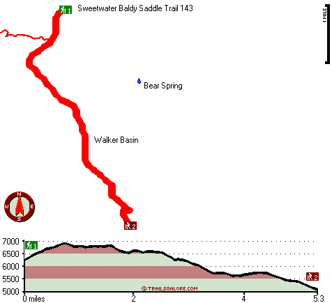
Trailhead 1 to Trailhead 2:
Total hiking length = 5.3 miles
Total climbing distance = 1.6 miles
Difficulty : Easy
Casual Hiking Pace: 4.5 hours
Fast Hiking Pace: 2.5 hours

Trailhead 2 to Trailhead 1:
Total hiking length = 5.3 miles
Total climbing distance = 3.1 miles
Difficulty : Medium
Casual Hiking Pace: 5 hours
Fast Hiking Pace: 3 hours
    Trailhead 1 back to Trailhead 1:
Total hiking length = 10.6 miles
Total climbing distance = 4.7 miles
Difficulty : Difficult
Casual Hiking Pace: 1.5 days
Fast Hiking Pace: 6 hours

Trailhead 2 back to Trailhead 2:
Total hiking length = 10.6 miles
Total climbing distance = 4.7 miles
Difficulty : Difficult
Casual Hiking Pace: 1.5 days
Fast Hiking Pace: 6 hours

Total elevation difference: 1909 feet


Holiday Inn Express GREEN VALLEY, Green Valley
15 miles away
Welcome to Holiday Inn Express Hotel located in the heart of the Sahuarita and Green Valley communities near Tucson. The only hotel having a heated indoor pool in Green Valley with spa, sun deck, comp...
  
The Inn At San Ignacio, Green Valley
15 miles away
The Inn at San Ignacio is a luxury villa-condo style hotel/resort located 20 miles south of Tucson in Green Valley, Arizona. The Inn features beautiful villa rooms and luxury villa suites with fantas...
User input for Walker Basin Trail Number One Hundred Thirty Six, Santa Cruz County, Arizona:

Submit Input:
Your Name:
Write or Paste Input here:

Upload picture:      Review Guidelines


Outdoors Recreation Near Nogales, Arizona
Very comprehensive list of a variety of outdoors recreation in the vicinity of Nogales, Arizona, the metro area neareast to Walker Basin Trail Number One Hundred Thirty Six. Find info on campgrounds, hiking trails, ski resorts, lakes, beaches, parks, whitewater and more.

Current weather conditions at Walker Basin Trail Number One Hundred Thirty Six, Santa Cruz County, Arizona
WXPort

Local climate location: TUMACACORI NATL MON 24 miles away

Tubac Golf Resort, Tubac
16 miles away
Southern Arizona's Historical Landmark Resort & a member of the distinctive Historic Hotels of America & Preferred Hotel Group Partner surrounded by towering cottonwood trees and mountain views. 99 l...

Tubac Country Inn, Tubac
16 miles away
Tubac Country Inn is the place to stay in Tubac, whether it be for a romantic evening walking the village, dining and walking back under the stars; or relocating,or visiting your family or shopping t...

More Hotels and Campgrounds Near Walker Basin Trail Number One Hundred Thirty Six, Santa Cruz County, Arizona

OTHER_INFO
  Arizona Hiking Trails
Complete list of all hiking trails in Arizona

Books about hiking trails in Arizona
List of books available on Amazon.com about hiking trails in Arizona.

Arizona Outdoors Index
This is a very comprehensive index of outdoors activities in the great state of Arizona.


TOPO
High quality water resistant topo map of Walker Basin Trail Number One Hundred Thirty Six, Santa Cruz County, Arizona.

OUTDOORS_GUIDE
These outdoors activities are available near Walker Basin Trail Number One Hundred Thirty Six.
 Trails Near Walker Basin Trail Number One Hundred Thirty Six:
Sweetwater Baldy Saddle Trail 143, Santa Cruz County , 1 miles away, 3.1 hiking miles, 2923 feet elevation difference
Cave Canyon Trail One Hundred Forty-Seven, Santa Cruz County , 2 miles away,  6.4 hiking miles, 2329 feet elevation difference
Kent Spring Trail 156, Santa Cruz County , 3 miles away, 3.5 hiking miles, 1398 feet elevation difference
Old Baldy National Recreation Trail Loop, Santa Cruz County , 3 miles away,  6.4 hiking miles, 1696 feet elevation difference
 Camp Grounds Near Walker Basin Trail Number One Hundred Thirty Six:
Bog Springs Campground, Pima County, 4 miles away
Patagonia RV Park, Patagonia, 10 miles away
Lake Patagonia Campground, Santa Cruz County, 11 miles away
Mountain View Campgrounds, Amado, 16 miles away
Green Valley RV Resort Park, Green Valley, 17 miles away
 National Parks Near Walker Basin Trail Number One Hundred Thirty Six:
Saguaro National Park, Tucson - AZ , 29 miles away
 Hotels Near Walker Basin Trail Number One Hundred Thirty Six:
Holiday Inn Express GREEN VALLEY, Green Valley , 15 miles away
The Inn At San Ignacio, Green Valley , 15 miles away
Tubac Golf Resort, Tubac , 16 miles away
Tubac Country Inn, Tubac , 16 miles away
Comfort Inn Green Valley, Green Valley , 16 miles away
 Lakes Near Walker Basin Trail Number One Hundred Thirty Six
Bathtub Water, Santa Cruz County , 3 miles away

Outdoors related information copyright © Stratus-Pikpuk, Inc. - Detailed hotel information copyright © Interactive Hotel Solutions