| |
|
| | Spending too much time indoors got you down? No problem, Walker Basin Trail in Yavapai County, Arizona is a really wonderful spot to spend some time. There are so many perfect trails for trekking in Arizona; Walker Basin Trail in Yavapai County is one of them. Going for a backcountry walk here in Arizona is the perfect thing to do. Don’t forget to check for any current restrictions or closures before you go. The total elevation difference for Walker Basin Trail is 2,662 feet which is higher than average. This is one of many backpacking trails in the surrounding |
|
neighborhood. Walker Basin Trail is a two ended trail with two trailheads which means you have the option of backcountry hiking it one way if you have someone to pick you up at the other end. Every Arizona trail has something unique to offer. A visit to Arizona is not complete
| | without some hiking. Walker Basin Trail is a very long great outdoors hiking trail having an average number of uphill miles which makes it an excellent backpacking trail for experienced hikers in good shape. Of course, this is an overnight walk, 2.5 days normally, so make sure you've got all your overnight gear packed. A lengthy journey separates Prescott from Walker Basin Trail, but backcountry trekking it is wonderful enjoyment any time. Now this backcountry trail is pretty long, so make sure you bring plenty of supplies. Being 15.8 miles long; it's | |
|
longer than many hiking trails. From a rain point of view Walker Basin Trail is a quite normal location; of all the months in a year March is the one with the most rain while June is mostly the driest month. This vicinity does get very dry sometimes, so make sure you check current
conditions and fire restrictions with local forest authorities before you head out. For the duration of the warmest time of the year highs here at Walker Basin Trail reach the 80's. Summer nighttime lows fall down to the 50's. The wintertime comes with highs in the 50's, and nighttime
lows at Walker Basin Trail during the wintertime commonly fall into the 20's. This hiking trail goes through some very different elevations, and that means that some parts of the hiking trail could be very different from other parts of it.
Briefly about the general area:
If time allows, Montezuma Castle National Monument is a national park worth stopping at; the beauty of mother nature reveals herself at Lander Spring. Beaver Creek has a glorious whitewater paddling spot nearby. There's so much to do here at Walker Basin Trail that you need to
camp here for a while, Beaver Creek Campground is a nice site for that. Walker Creek flows through this vicinity; Walker Basin Trail is nice enough to spend more than a day at, Clear Creek Campground is a nice local campground. A quick trip to Spring Creek near Walker Basin
Trail is a tremendous idea, and a journey to Soda Spring will fill your spirit with wonderful feelings. A journey to Walker Basin revives the soul, and if you don't mind getting dripping wet, you can always go whitewater paddling on Wet Beaver Creek. Yeah, come here to Walker Basin Trail for a wonderful time. Everybody loves Blodgett Basin, and close by you discover splendid spots like Casner Canyon.
|
|
Location of Trailhead 1: Latitude 34.6418, Longitude -111.7195 - - Directions and Road Map
Location of Trailhead 2: Latitude 34.5845, Longitude -111.6436 - - Directions and Road Map

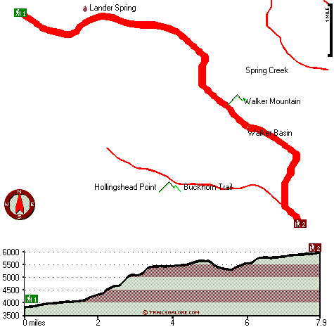
Trailhead 1 to Trailhead 2: Total hiking length = 7.9 miles Total climbing distance = 5.4 miles Difficulty : Difficult Casual Hiking Pace:
8.5 hours
Fast Hiking Pace:
4.5 hours
Trailhead 2 to Trailhead 1: Total hiking length = 7.9 miles Total climbing distance = .9 miles Difficulty : Difficult Casual Hiking Pace:
5.5 hours
Fast Hiking Pace:
3 hours
| | Trailhead 1 back to Trailhead 1: Total hiking length = 15.8 miles Total climbing distance = 6.3 miles Difficulty : Difficult Casual Hiking Pace:
2.5 days
Fast Hiking Pace:
9 hours
Trailhead 2 back to Trailhead 2: Total hiking length = 15.8 miles Total climbing distance = 6.3 miles Difficulty : Difficult Casual Hiking Pace:
2.5 days
Fast Hiking Pace:
9 hours
|
Total elevation difference: 2662 feet

Las Posadas of Sedona, Sedona
|
9 miles away
It is a luxury inn. It is a collection of spacious suites. It is an upscale B and B built with privacy in mind. It is the best of all possible worlds. And the location is stunning. Nestled in Sedona...
|
| |
The Views Inn Sedona, Sedona
|
10 miles away
*A Boutique Inn featuring Southwest charm and breathtaking Red Rock Views.* The Views Inn Sedona is a boutique Hotel located in the heart of Red Rock Country, just south of Sedona in the Village of Oa...
|
|
User input for Walker Basin Trail, Yavapai County, Arizona:

Outdoors Recreation Near Prescott, Arizona Very comprehensive list of a variety of outdoors recreation in the vicinity of Prescott, Arizona, the metro area neareast to Walker Basin Trail. Find info on campgrounds, hiking trails, ski resorts, lakes, beaches, parks, whitewater and more.
More Hotels and Campgrounds Near Walker Basin Trail, Yavapai County, Arizona
| |
| |
 |
|
| These outdoors activities are available near Walker Basin Trail. |
| | Trails Near Walker Basin Trail:
 |
Deadwood Trail, Yavapai
County
, 1 miles away, 7.9 hiking miles, 2150 feet elevation difference |
 |
Long Canyon Trail, Yavapai
County
, 2 miles away, 14.6 hiking miles, 2092 feet elevation difference |
 |
Buckhorn Trail, Yavapai
County
, 3 miles away, 3.7 hiking miles, 1912 feet elevation difference |
 |
Bell Trail, Yavapai
County
, 3 miles away, 10 hiking miles, 2165 feet elevation difference |
 |
Apache Maid Trail, Yavapai
County
, 6 miles away, 8 hiking miles, 2787 feet elevation difference |
 |
Towel Creek Trail Sixty Six - Sixty Seven Loop, Yavapai
County
, 11 miles away, 5.8 hiking miles, 2408 feet elevation difference |
|
| | Whitewater Near Walker Basin Trail:
 |
Wet Beaver Creek, Yavapai County
County
, 6 miles away, Class -blank- - 9 miles long (Beaver Ranger Station to Beaver Creek) |
 |
Beaver Creek, Yavapai County
County
, 11 miles away, Class -blank- - 9 miles long (Wet Beaver Creek to Verde River) |
 |
Verde River, Yavapai County
County
, 12 miles away, Class -blank- - 8 miles long (Camp Verde to Beasley Flat) |
 |
Verde River, Yavapai County
County
, 14 miles away, Class II-IV - 7 miles long (Beasley Flat to Gap Creek) |
 |
Oak Creek, Coconino/ Yavapai County
County
, 14 miles away, Class -blank- - 35 miles long (Pump Stabove Sedona Cornville to Verde River) |
|
| | National Parks Near Walker Basin Trail:
 |
Montezuma Castle National Monument, Camp Verde - AZ
, 12 miles away |
 |
Tuzigoot National Monument, Clarkdale - AZ
, 12 miles away |
 |
Walnut Canyon National Monument, Flagstaff - AZ
, 35 miles away |
|
| | Hotels Near Walker Basin Trail:
 |
Las Posadas of Sedona, Sedona
, 9 miles away |
 |
The Views Inn Sedona, Sedona
, 10 miles away |
 |
Kokopelli Inn, Sedona
, 10 miles away |
 |
Desert Quail Inn, Sedona
, 10 miles away |
 |
Ridge On Sedona Golf Resort, Sedona
, 10 miles away |
|
|
|
 |
|